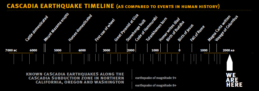
LONG BEFORE EUROPEANS LANDED ON THESE SHORES, the Cascadian Subduction Zone has terrified denizens of the Pacific Northwest. The region has endured six earthquakes of magnitude 9.0 — or more — over the past 100 years. What will happen when our region’s backbone finally snaps?
Throughout human history, in our search for comfort and control, we’ve assigned explanations to the unknowable. Our fear of death prompts us to remember the Judeo-Christian story of Eden and the creation of an afterlife. Plagued by questions unanswerable, the ancient Greeks imagined gods and deities far more powerful than mere mortals in an attempt to understand the complex and mystifying notions of love, war, death, injustice, and the unseeable universe beyond our own.
In Cascadia, a fear of near mythical proportions belongs to us alone. It lies beneath the surface of the Pacific Ocean, and if it resurrects itself during our lifetime, we will feel our own slice of Eden is being decimated at the hands of something otherworldly. Though there is a logical explanation for the Cascadian Fault — our modern-day Kraken — the science behind it and its impending destruction make it all the more terrifying for those who monitor it.
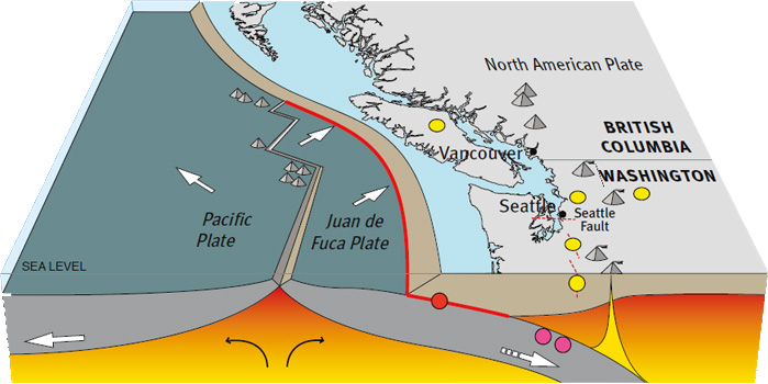
Stretching from northern Vancouver Island to northern California, the Cascadia Subduction Zone — or, the Cascadian Fault — is a break in the Earth’s crust that separates the Pacific Plate and the Juan de Fuca Plate, both which lie below the continental crust. The former is a thinner oceanic plate that is slipping below the offshore crust of the Pacific Northwest as the North American plate moves in a general southwest direction.
As the oceanic plate slips further underneath, its temperature increases until it is no longer able to store mechanical stress, releasing the energy as the plates inevitably slip, resulting in what is known as a “megathrust” earthquake, the name given to seismic activity that occurs at the convergence of multiple plates. This type of earthquake is the most powerful, and all six earthquakes that have occurred in the last 100 years with a magnitude of 9.0 or higher have been a result of this tectonic activity.
The geological setting off the coast of Japan, where the Pacific Plate dips under one of the plates beneath northern Honshu, provides a near replica of the Cascadian Fault. The magnitude 9.0 megathrust earthquake that rocked Japan in 2011 provides a glimpse into the devastation that could occur along the Cascadian range coast. The Tohoku earthquake was the fifth most powerful earthquake on record, causing nearly 16,000 deaths and resulting in nuclear accidents that continue to haunt the west coast of Canada, United States, and — as some believe — the entire northern hemisphere.
The Cascadia Subduction Zone is a 1,000-kilometre-long dipping fault that stretches from northern Vancouver Island to Cape Mendocino, California, separating the Juan de Fuca and North America Plates. Here, the oceanic crust of the Pacific Ocean has been sinking beneath the continent for about 200 million years and currently does so at a rate of approximately 40 millimetres annually. At depths shallower than 30 kilometres, the fault is locked by friction while strain slowly builds up.
Jerry Thompson — journalist, documentarian and former reporter for the CBC — has been studying the Cascadia Fault for the past 30 years. Thompson released Cascadia’s Fault in 2011, a book he hopes will urge greater preparedness in the areas that would be affected when an earthquake with the magnitude of the Tohoku earthquake, which was preceded by unrelated events in Sumatra in 2004 and Chile in 2010, finally occurs in our own backyard.
Thompson documents how the Cascadian Fault has become a part of Pacific Northwest consciousness, beginning with an oral tradition from tribal elders in villages that span the length of the fault, all of whom described tidal waves and the destruction of entire communities. The initial scientific discoveries that corroborated these legends were “ghost forests,” cedar and fir trees killed by saltwater that created a literal high water mark along the shores that dropped several feet during an earthquake. Carbon dating confirms these events happened some time between 1680 and 1720. Tsunami sand deposits have been found along the coast between Vancouver and California, providing a valuable clue about the event’s magnitude.
In an ominous nod to the geological connection between Japan and the Cascadian region, two seismologists who began studying Japan’s historical earthquakes in the 1970s suspected that a major earthquake on North America’s west coast would send shockwaves that would be felt on the other side of the Pacific. Japanese records of geological activity date back three centuries, and they found repeated detail of damage along the Japanese coast in 1700, and many of these same villages were hit in the 2011 Tohoku earthquake. The former was described as an “orphan tsunami” because Japan never experienced the “parent earthquake” that caused it, and it was later concluded that the Cascadia Subduction Zone was the point of origin.
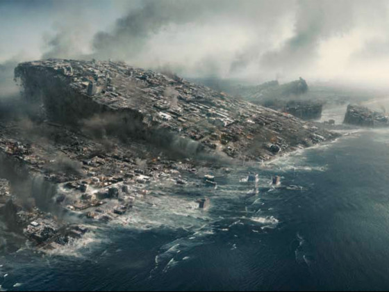
While it’s possible that the Cascadian Fault could rupture in sections, resulting in a series of smaller earthquakes, experts believe planning for the worst-case scenario is a reasonable approach considering that if a megathrust earthquake ruptured along the 1,100-kilometre (684-mile) range it would hit five heavily populated areas virtually at once: Vancouver, Victoria, Seattle, Portland and Sacramento. Scientists, emergency managers, engineers and government officials working within the Pacific Northwest to predict and prepare for this exact kind of natural disaster paint a clear, sobering picture of the chain of events when “The Big One” finally hits.
A 9.0 megathrust earthquake would result in four to six minutes of ground shaking, during which unreinforced masonry buildings, that is, any building erected without steel reinforcement — more common in British Columbia, Washington and Oregon than California — are prone to collapse. Roads and bridges along the coast will suffer serious damage, and older bridges will collapse all together. The steep mountain ranges and inland waterways common along the west coast, particularly around the Columbia River, Puget Sound and the Straits surrounding Vancouver Island, will make alternative routes difficult, if not impossible, isolating coastal towns along with island communities that rely on bridges and ferries.
Widespread power outages are a given, potentially leaving millions of Cascadians without communications, and restoration times will range from weeks to months for areas near the coast. Drinking water service will be interrupted, fuel shortages are likely due to underground damage to pipelines and furthered by port damage, and will interfere with the transportation of critical supplies. Downed electrical lines and ruptured natural gas pipelines often start fires during major earthquakes.
The next challenge is a near-source tsunami, resulting in the displacement of water after the Pacific Plate pushes up from underneath the seabed. Unlike tides caused by wind, this kind of tsunami has been described as a moving plateau of water. The subduction zone’s close proximity to the coast is disconcerting, as residents will have less than 30 minutes to evacuate before the first waves meet with the shore, and as little as 15 minutes for those in northern California. Population density, travel distance to higher ground and reliance on vehicles will affect evacuation success rates. It is predicted that the largest population centers in the Pacific Northwest, including Portland, Seattle and Vancouver, are not expected to suffer major tsunami impacts, but are susceptible to destructive currents. Aftershocks may begin within hours and can continue for months afterward, with the potential to bring down already weakened buildings. Multiple waves will follow the initial tsunami after a matter of hours.
A megathrust earthquake of the Cascadian Fault would result in fewer casualties and less infrastructure damage than in Japan’s 2011 earthquake, simply because of a lower population density. Economic impact for the US alone is estimated at upward of $70 billion.
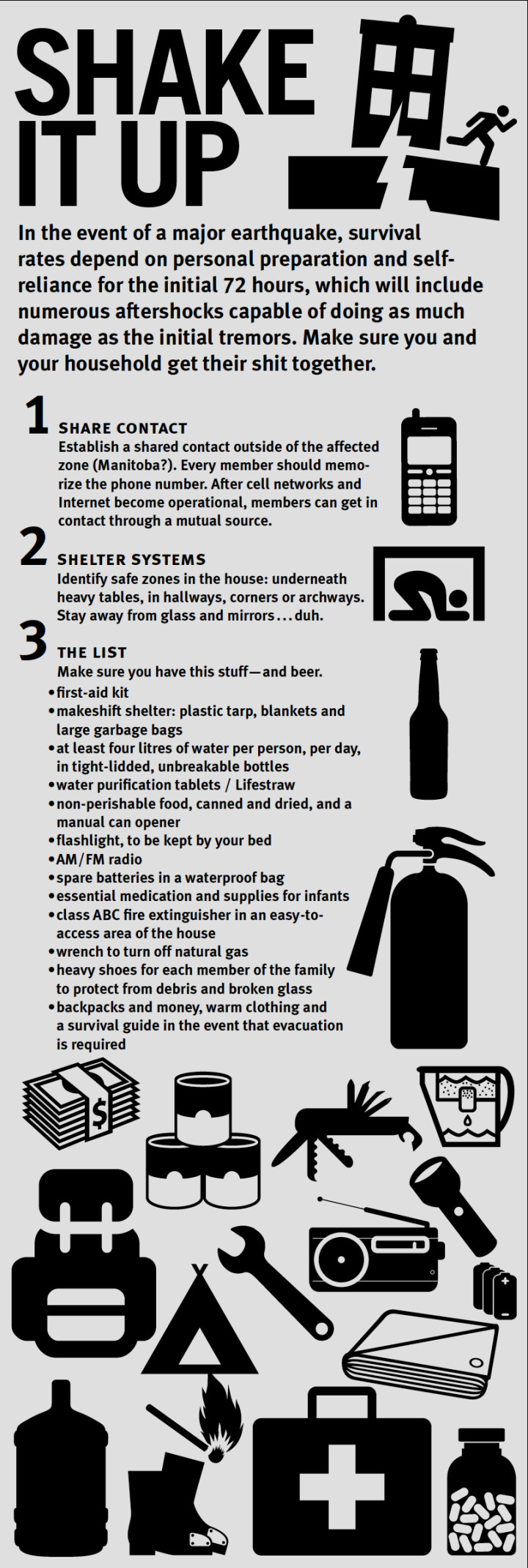
“The reality is we’re not all going to die. The vast majority of us are going to survive this thing. The important question is how well we endure the aftermath,” explains Cascadia Fault author Thompson. And according to him, this depends on how well we prepare. Our preparation, both in terms of government and municipal readiness and, of equal or greater importance, household preparation, depends on our ability to accept a major earthquake and accompanying tsunami as a serious threat.
The point that Thompson stresses is that it’s only a matter of time. The monumental megathrust earthquake described could occur in 50 years or in 150 years. Or we could be jarred awake before the next sunrise to the destruction of our coastline, something we usually see in foreign news reports broadcast from places that seem worlds away. In reality the Japanese earthquake was, in basic scientific terms, inevitable activity occurring on another corner of the same tectonic plate that we fish, surf, swim and sail above. It literally happened to our home, and it will happen again.
This uncertain timing is the reason why some people are able to ignore the underwater activity that threatens Cascadian residents. It’s also the reason why others can’t look out at a blue horizon, no matter how peaceful, without wondering when that inescapable monster below will finally surface and attempt to drag us under. But even Thompson, who currently resides in very vulnerable Sechelt on British Columbia’s Sunshine Coast, tempers the scientific data with the reality of our everyday conditions.
“We’re not going to let it run us out of paradise.”