Multicultural, open minded and surrounded by beautiful stretches of nature, San Francisco Bay Area is one of the most diverse places in California. Drive along the coast north or south of San Francisco and in less that one hour you’ll be witnessing surf crashing on cliffs, national parks, waterfalls, and many trails. There are over 600 trails, from easy walks to technical hikes. Here are trails that range from an urban environment as well as off the grid places. Most of this trails can be placed in the easy-medium difficulty range and can suit the average hiker. The weather in this region changes drastically, sometimes even throughout the day, make sure to bring have enough layers to keep you warm even during the summer.
Editor’s note: These spots are all taken directly from travelstoke®, a new app from Matador that connects you with fellow travelers and locals, and helps you build trip itineraries with spots that integrate seamlessly into Google Maps and Uber. Download the app to add any of the spots below directly to your future trips.
The beauty of the surrounding nature is not the only special aspect of this trail, urban development plays a big role in the Land’s End scenery. Follow the Great Highway along Ocean Beach to Point Lobos Avenue. 400 ft past Cliff House restaurant on the left there is the Marrie Way parking lot and the trail’s head. As soon as the hike begins there is a path to the Sutro baths, which are now an impressive ruin. The structure was designed by Adolph Sutro in the late 19th century as a recreational area and bathhouse for the working class folks. About half mile on the right another path leads to the Palace of the Legion of Honor art museum. The main trail winds up at Eagle’s Point, a breathtaking overlook at the bay and the Golden Gate Bridge and a perfect spot for a break before heading back to the parking lot.
An hour drive north of San Francisco on Highway 1 past the Bolinas Lagoon there is a left turn (it’s not often signed) on the Olema-Bolinas Road that leads to downtown Bolinas. Take a right turn on Mesa Road and you’ll come across the trailhead after 5.8 miles. Being part of the 15-mile Coast Trail, a two-day backpacking hike, this trail is often busy, especially in springtime. The first part of the hike is easy and for the majority of the time the road runs along a beautiful cliff. The trail turns inland and heads towards the lakes, Bass Lake, Crystal Lake and Pelican Lake. All three lakes are accessible by visible small detours from the main trail. After the last lake, an unmarked left turnoff (many hikers miss it) leads to the waterfalls. The main trail keeps straight toward the Wildcat Camp, which is the perfect spot to pitch a tent for the night. Once out of the narrow and overgrown with poison oak trail the scenery starts to unfold, from here a steep route goes all the way down to the beach for a stunning view of the waterfalls cascading into the sand.
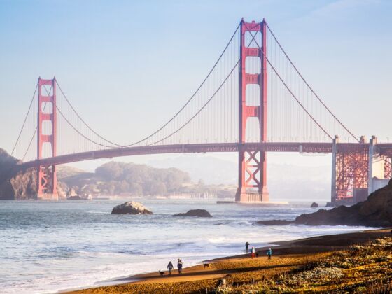
Coming from Geary Boulevard, make a right turn on 25th Avenue then a right on El Camino del Mar, follow the direction to Baker Beach, a well marked left turn off. The view of the Golden Gate Bridge from the parking lot is already astonishing, and the very first battery is right behind Baker beach at the beginning of the trail. This hike is a pleasant mix of stunning views of the ocean, nature and a series of artillery batteries from the ‘800 – ‘900. Along the trail, each battery has an overlook and resting area where you can enjoy a little break while reading up on the history of the region. Once closer to the GG bridge the trail goes underneath the highway. From here it is possible to continue towards Crissy fields and see the bridge from below or take the trail up to the Welcome Center and keep on walking on the bridge. Stop for a coffee break at the Bridge Cafe.
Marin Headlands is home to various trails and hikes for all levels. Drive north crossing the Golden Gate Bridge and take the exit for Alexander Avenue and follow it on the left, then right on Conzelman Rd to the parking lot. It is possible to park at one of the lookouts, but the lots are very small and usually crowded. The trailhead is situated at the lower parking lot and winds its way inland. After a mile take the left turn into the Coastal trail. There is a left turn for a short detour to Slackers Hill. The main trail runs through some patches of high vegetation although it is mostly an open space hike. When the road splits in two take the left to the Point Bonita. Stay on the main trail until it crosses Simmonds Rd and heads to the Marin Headlands Visitor Center. The lovely walk follows the banks of the Rodeo Lagoon and ends to the beach. In order to explore more of this area, there is the option to spend a night at the HI-Marin Headland Hostel, just a short walk from the Visitor Center.
Coming from downtown, Market St. becomes Portola Dr., take a left onto Marne Ave., another right on Juanita Way, and a left on Dalewood Way, the park entrance is on the left. Although this area is surrounded by urban development and it is easy to get lost while following unmarked trails. Mt. Davidson forest is mostly blue gum eucalyptus trees which offer cover for bird nests and food sources for other animals and provide habitat for more than 250 species of insects. At the junction bear left and at the second make a right, the broad clearing is dominated by the Mount Davidson cross built to commemorate the Armenian genocide. To reach the lookout walk east on the East Ridge trail till the fire road, the view of the city will unfold each step taken down the flat summit.
Get ready for a strenuous climb, heat (during autumn/spring) or rain and fog (during winter/summer), horseflies and rewarding views of the north Californian coast. Wear comfortable boots and make sure to bring snacks and water, you might consider consuming breakfast at Breakers Cafè or Parkside Cafè both within a short walk distance from the fire station.The trails in this area are numerous, but the most charming one is without a doubt the Matt Davis trail. It goes from Stinson Beach Fire station, one hour drive north from SF on highway 1, to Mt. Tamalpais east peak. After 13 miles of moderate walking, steep hills, creeks and fascinating vegetation, Matt Davis trail takes the adventure to the next level. If spending the night in the park, take the Steep Ravine trail and stop at the Pantoll Campground or at the West Point Inn. The 365° panoramic view from the east peak is a great payback for the effort put in the climb. Coming down on the Matt Davis trail take a break at the Mountain Amphitheater where shows take place during the summer.
Coming from San Francisco on the U.S. 101 take the Brisbane/Cow Palace exit and drive on Bayshore Boulevard for 1.8 miles, then turn left on Guadalupe Canyon, the park entrance is in 2.3 miles. There is a parking lot on each side of the road, the one on the left is closer to the Summit Loop trailhead. The easy 3.1 miles round-trip trail is a loop that can be hiked in either direction and offers numerous view of the city of San Francisco from different perspectives. Flowers bloom numerously during spring and the vegetation is predominately low so hiking during a sunny and very hot day might be tricky. A hat and plenty of water are recommended. The endangered Mission blue butterflies find a home here and in the Golden Gate National Park only, as well as the San Bruno Elfin Butterfly (also endangered) and the Montara manzanita plant. At the junction, the left turn is a shorter route to the summit with dramatic views almost immediately. Keep clockwise, as the right option is an easier grade to the summit. From there the signed trail starts its downhill on the right side of the gated road all the way back to parking lot. There is a $4 day-use fee per vehicle.
Park the car in any parking lot along Highway 1 in the corner with Fulton St. (it’s free and there is not time limit) and head to the Beach Chalet Brewery to start with a meal and a coffee. Leave the dutch windmill on your left and follow JFK Drive, this is the main street that stretches for the full length of the park. The various detours are very well marked and reach different points of interest. GG park has over ten lakes and a bison paddock and offers way more than pretty walks in nature. About half way through the park on the right hand you’ll find Stow Lake, make sure to take some time to walk around it. Head back to the main path and finish the day wondering around The Young Museum of Fine Arts before walking back towards the beach. Rental bikes are available inside the park, just be careful not to take pedestrian-only paths.