An Homage to the Birthplace of Modern Travel

Surfing Insider Guides Family Travel
by David Miller Mar 20, 2014

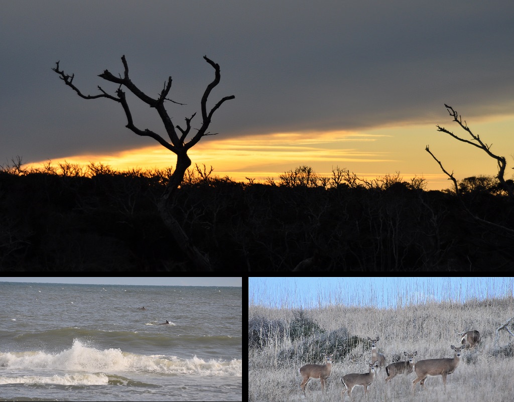
WE’D BEEN PATIENT MOST OF THE DRIVE. But somewhere around the 6th hour across North Carolina, having dropped from the highlands to the Piedmont to the coastal plain, past the damp winter fields of cotton stubble, past the endless stretches of pine flatwoods, the kids were getting restless. Nobody could wait to reach the Outer Banks.

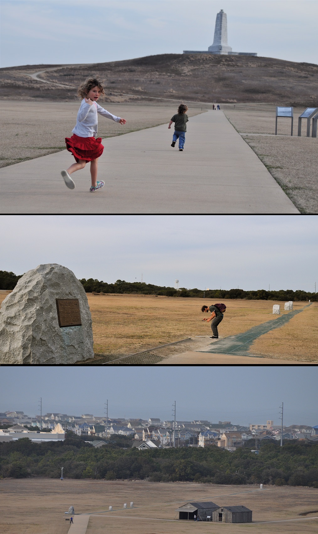
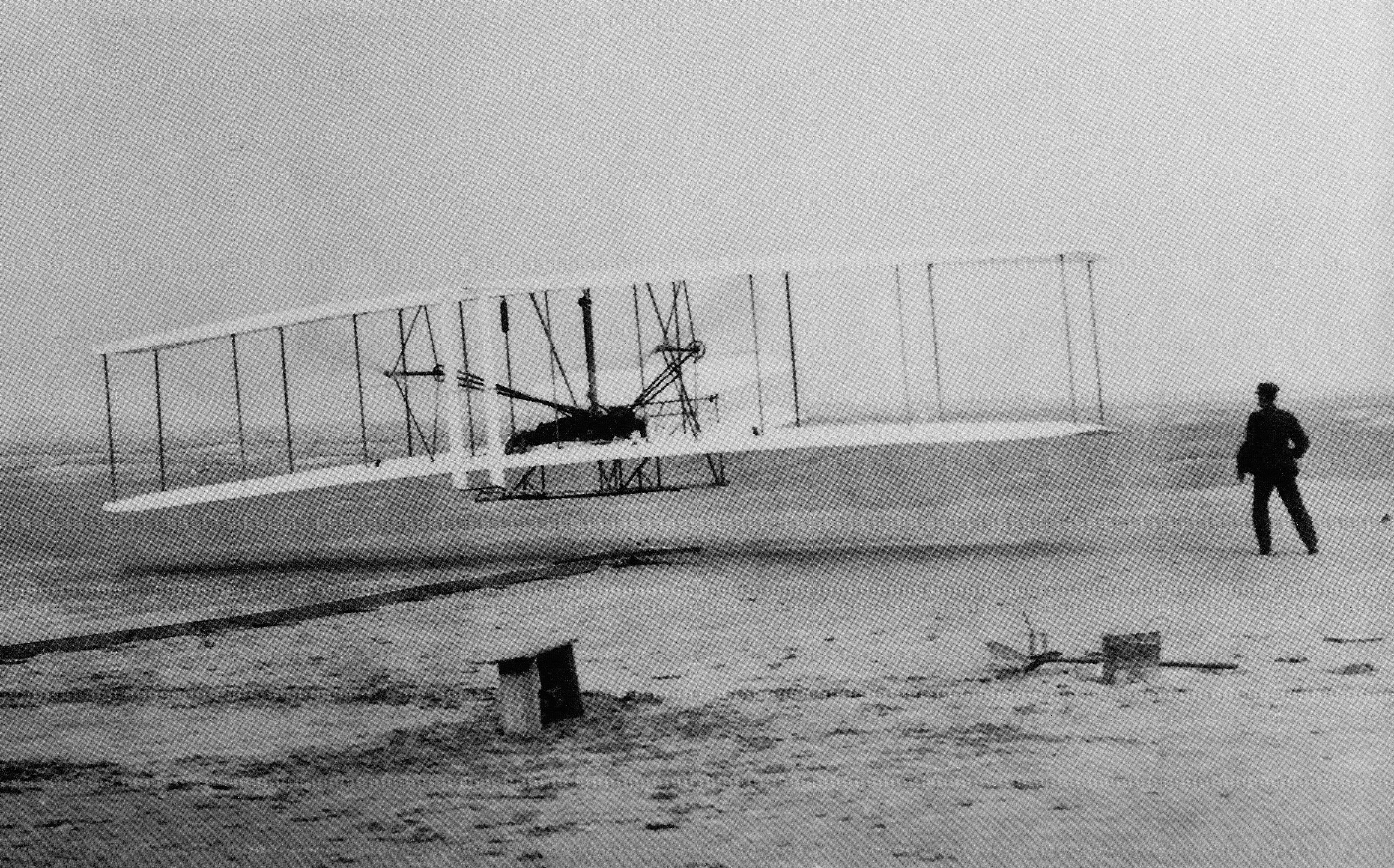
We’d been preparing for this trip. I checked out books on the Wright Brothers, who had become funny-hatted characters in my kindergarten-aged kids’ stories. I wondered how old Orville and Wilbur would’ve perceived this road on their first trip from Dayton in 1900. What levels of anticipation must they have had in these last couple dozen miles?

The chain of barrier islands known as the Outer Banks — or OBX as it’s commonly abbreviated — juts off the coast of North Carolina, with the Albemarle Sound distancing it from any large cities (the closest is Norfolk, Virgina, about an hour and a half away). This was one of the reasons the Wright Brothers originally chose it as the site of their flight experiments. Beyond just winds and soft dunes, it was an area out of the public eye.

This distance makes OBX a kind of mini-pilgrimage for many travelers, especially East Coast surfers and anglers. For us, and for different reasons, the Outer Banks is as good as it can get in our part of the world. For one, whereas most of the Atlantic is characterized by a shallow continental shelf that diminishes wave-power, OBX’s geography and steep dropoff allows swells to break harder, similar to the Pacific. Kelly Slater said about the role of Hatteras (the most eastward jutting point of OBX) in his surfing development: “Hatteras was my Pipeline, my Mecca.”

But OBX’s position in the Atlantic is also a convergence zone of two major ocean currents — the Labrador flowing south from the Arctic and the warm Gulf Stream flowing north — which results in an incredible biodiversity of marine life and some of the best fishing in the Atlantic.

I wondered how old Orville and Wilbur would’ve perceived this road on their first trip from Dayton in 1900. What levels of anticipation must they have had in these last couple dozen miles?

Just when it seemed we couldn’t take any more driving, we were on the bridge crossing the Alligator River, and into a kind of terrain I’d never seen before. It looked similar to bogs down in Florida, but with different vegetation. These were pocosins, upland swamps full of tupelo trees, pond pine, and venus flytrap. I was partly tempted to turn into one of the sandy entrances to the Alligator River Wildlife persevere — but kept going across another long bridge to Roanoke Island, site of Sir Walter Raleigh’s English colony in 1587 — later known as the “Lost” Colony. I tried to explain this somewhat arcane piece of history to my wife (a native of Argentina), and kids. “Where did the colonists go?”

I sided with historians who believe these colonists eventually integrated with descendants of the local Roanoke Indians, who had been friendly with the English (and likely helped them survive) on their first encounter in the New World.

The final bridge took us across Roanoke Sound and onto the Outer Banks proper. There was a weird light to the early afternoon as the thick cloud banks that were overhead all day now pushed out to sea. After a somewhat bleak February morning, from the giant dunes at Jockey’s Ridge to the low country buildings of Nags Head and Kill Devil Hills, everything seemed to glow warmly. Passing several kite stores, whose banners and windsocks flapped strongly towards the sea, I got super excited about the prospect of offshore wind and possibly great wave conditions.

Over the next four days we explored various pockets of the Outer Banks, from north near the Virginia border on a 4×4 beach road past Corolla, to down south along the National Seashore to Cape Hatteras. I found many parts of the trip strangely moving. From the early contact of the English with the Native Americans here, to the long stretches of open coast where Blackbeard and so many other pirates (including inland pirates that ambushed floundering vessels) pillaged and eventually perished, there seem to be so many juxtapositions of history — particularly the history of travel — in this raw edge of the US coast.

Perhaps most of all, as travelers we all tend to take for granted that every time we get on a plane, the very principles of flight, the system of controls used by pilots today, goes back to the Wright Brothers. They figured it out. The whole concept of adapting to changing wind conditions by “wing warping” goes back to their summers testing out gliders, and then, finally, planes, at Kill Devil Hills. It feels like a hallowed ground out there, made more powerful by the fact that it’s not a closed off museum but the same wide open fields where they camped and flew. You can walk in the same places and feel these same winds.

Here were some of our highlights:

Wright Brothers National Memorial, Kill Devil Hills

The Wright Brothers Memorial

The set of images gives you an idea of the scale of this place. The stone marker in the middle image shows the launch spot (including a replica of the rail used by the Wright Brothers to launch their plane). The smaller markers set out at different distances show the landing spots of the first four flights on December 17, 1903. The fourth flight was 852 feet, with the “flyer” in the air for 59 seconds.

This was the fourth year that the Wright Brothers had come to the Outer Banks (a replica of their camp building and hangar is in the bottom shot). The first three years they made thousands of test flights in different model gliders — both manned and using the gliders as kites — slowly developing the concept they called “wing warping,” adjusting to changing wind conditions and actively turning / flying the craft.

A week before we arrived there was a large snow event in the southern US; more than 6 inches fell in Kill Devil Hills, and locals came to the monument to sled / snowboard.

Jennette’s Pier, Nags Head

fishing janettes pier

“I wish I could create a computer model of what I saw when I come up the ramp each morning.” This was how Chris Crockett (pictured left) described how he sees the water — and the always changing currents, tides, wind, weather, even sand compositions along the beach — that are all interrelated and help one understand where and how to fish. Born in Emerald Isle, he’s spent his entire life as a waterman on the shores of North Carolina. On the pro surfing tour as a grom, and learning boat-building and fishing “from the old-timers,” he’s now an outdoor educator who has taught thousands of North Carolina youth who come each year to Jennette’s Pier. A state-run facility, Jennette’s is both a working ocean research center and an educational facility offering programs in biology of fish, alternative energy (Jennette’s Pier is itself powered by wind and solar), beach exploration, water runoff, plankton, and Crockett’s obvious favorite, fishing.

The fish weren’t biting that morning, so he gave Layla (6) and Micael (3) a beginner’s lesson on identifying common local species (drum, spot) and practice casting.

“If people would just listen to me,” he said, “and everyone just took a break from inland netting and fishing for a year, this would be the best fishery in the world.”

Corolla, North Carolina

Wild Spanish Mustangs

The island of Corolla, North Carolina, is only accessibly by 4×4. If you spend enough time driving along the beach and the various beach houses scattered around the island, you’ll eventually see wild horses. Supposedly this is the only place in North America with this particular horse, which has no domestic blood, but is all descended from the same thoroughbred families of colonial Spanish Mustangs that have been on the island for 575 years. The horses are not afraid of humans and basically just wander the island grazing and taking shelter wherever and however they please.

Surfing OBX

surf montage

There wasn’t enough swell while we were there to really shortboard, but I got fun rides in my kayak. Water temp was a frigid 39 degrees, meaning short sessions, empty breaks. It’s just you and dolphins.

Note the tire tracks. People with ORV passes can drive along different beaches in the Outer Banks. At first this threw me: I’m not used to seeing vehicles when I’m out on the beach. But later I realized how good this makes it for locals (and the potential for epic exploration if you have the right vehicle). There’s a huge community of anglers and surfers who can dial in exactly where they want to surf or fish, and being able to drive the beach gives them next-level access.

A couple more things about the Outer Banks: (1) Be careful out there. The steep dropoff is way different than most other beaches along the Atlantic, and it would be easy to get swept out into water deeper than you could stand up in by the shorebreak. (2) Surf conditions in OBX are no joke; it can go off with as perfect wave conditions as you can imagine. Check this shot of last year’s Outer Banks Pro at Jennette’s Pier for reference. Image via WRV:

surf

Jockey’s Ridge

Jockey's Ridge montage

Jockey’s Ridge State Park contains the largest sand dunes on the Atlantic, and stretches eastward to Roanoke Sound, allowing you to explore from the dunes back to tidelands. The morning we visited was clear and mild, perfect for flying kites and, as we saw, to learn to fly a para-glider (several local outfitters use Jockey’s Ridge as a training ground for hang gliding lessons.) When you’re atop the dunes you get sweet views both out to the Atlantic as well as back into the sound. We could’ve easily explored here all day.

Cape Hatteras National Seashore

wildlife montage

Hatteras is one of only 10 federally protected national seashores in the US. It has the feel of driving into a national park, with day-use / picnic areas and bathrooms along the way and four campgrounds, each giving an epic setup for extended surf / fish / kayaking trips. The campgrounds are closed in winter, unfortunately, but the Frisco Woods private campground is open year-round.

We saw a ton of wildlife on Hatteras, including these deer which came out at dusk. The dolphins were feeding all day just off the shorebreak. It was pretty windblown and cold, giving a kind of gnarly feel, making it not hard to imagine this area as the “Graveyard of the Atlantic” — a name conferred after the hundreds and possibly thousands of shipwrecks at the Diamond Shoals, a twelve-mile-long sandbar off this stretch of coast where southbound ship are driven by the current.

mid HATTERAS

More than anything about being here, it came down to a feeling of solitude and being able to just regroup as a family. I felt lucky to see this place for the first time in the winter, when the population is only 7,000 in Kill Devil Hills (it grows to 40,000 in summer), and the conversations in lines at the grocery stores and gas stations were always slow paced and centered around fishing spots and swell predictions. On the way out I thought again of Wilbur and Orville, wondering at the international fame and crazy trajectory their lives took after their invention. I wondered how much they thought back on those dunes and winds, the place where — out of view from the rest of the world — they finally got off the ground.

OBX LOGO
Editor’s note: Accommodations provided by our friends at The Outer Banks Visitors Bureau.

Discover Matador