Surfing pumphouse wave on Sweetwater Creek near Atlanta. Photo by Brad Roberts

Escape to Adventure: Atlanta

Travel Insider Guides Teva: Escape To Adventure
by David Miller Jul 15, 2011
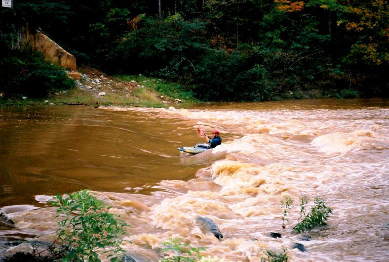
Although the Atlanta metro area has gotten blown out with traffic and people over the last decade (current population is over 5 million), quiet, empty places can still be found all around the surrounding Chattahoochee forest and watershed, where trails, creeks, cliffs, and all kinds of spots await exploration.
TEVA logo

TEVA has teamed up with Matador’s global community of outdoors fanatics to show you how to escape to adventure in 12 cities across America. In addition to the article series, we’ll be running an ongoing photo contest. Send us a photo of yourself adventuring abroad or in your back yard and you might win a free pair of new TEVAs.

ATLANTA is located in a region known as the Piedmont; it’s basically a plateau between the Atlantic coastal plain and the Appalachian mountains. Besides having lots of rolling hills, the terrain is characterized by rich deciduous forests threaded with creeks and wetlands draining to the Chattahoochee River.

Some of my earliest memories (around age 4) are of riding along Johnson Ferry Road towards my preschool / camp in Roswell, just north of Atlanta. At that time it was a country road, with nothing but farmland on either side, and heavily forested areas along the river.

Three decades later, a visitor at the intersection of Johnson Ferry and 120 might have a hard time imagining what it once looked like.

The good news is that all of the same trails and protected areas along the river are still there, and strangely, as seemingly unexplored as they ever were, even though the population and infrastructure has changed so much. All of the following adventures can be accessed – depending on traffic – from within the metro Atlanta area in around 30 minutes or less.

Kayaking

Escape Time: 30 minutes or less depending on location
Payoff: Flatwater to class III-IV whitewater right in the metro area

The Chattahoochee “Metro Run” has long been a training center for Olympians and juniors, and one of the best places to learn whitewater paddling in the country. Right after summer thunderstorms, or during long winter rains, there are also local creeks to run, some with stomping drops and play features, depending on the level. There are also lots of great flatwater stretches for those who just want to paddle recreational (“sit on top”) kayaks or canoes and just play around or fish or explore wildlife.

Metro Run

The Chattahoochee Metro Run begins literally right inside the Perimeter, and runs 3.5 miles through Metro Atlanta, although you’d never know it from the corridor of ancient cliffs and forested palisades. The river passes through several small sections of shoals and rapids with a few fun surfing waves and squirt lines for skilled boaters. This run is family friendly as long as everyone is a good swimmer.

Sweetwater Creek

Sweetwater Creek State Park is a sweet hiking spot during low water, and after a heavy rain it becomes this – as we like to call it – urban boof-fest. There are dozens of fun whitewater moves to be made on this run, and when the water is high enough (over 4 feet), the Falls become a significantly large class IV+ rapid.

Azalea Park

Azalea park is a great option for people who don’t have gear but just want to get out on the river. Boat rentals (rafts, canoes, recreational kayaks) are available. For information check shootthehooch.com.

Climbing / Bouldering

Escape time: 15-30 minutes depending on location
Payoff: great workout and cool local community

There is climbing and bouldering to be had in the metro area, particularly in Island Ford and the Palisades (both within in the Metro Hooch section mentioned above), and also at “The Boat,” an area of nearly 8 acres of boulders purchased by the Southeastern Climbers Coalition.

From SCC on ‘The Boat”:

This is the first stop on the intown ATL tour. Large granite boulders with a healthy texture make for lots of smearing, crimping and palming up aretes and blank walls like the “Paint Can,” “Lost Digits,” and “Dishes.”

Directions:

From downtown Atlanta go west on Interstate 20 past the junction of I-285 and I-20 to Fulton Industrial Boulevard and take exit 49 going south. Go southwest on Fulton Industrial Boulevard for 4.5 miles and at the second traffic light after the Quick Trip gas station, make a left on to Boat Rock Road. Drive 1.1 miles and take a right on a small asphalt driveway into a small 6 car gravel parking lot across from The Summitt at Cascade Subdivision. There is a small wooden sign marking the lot as “Boat Rock Preserve” 1221 Boat Rock Road. There is a small kiosk with info on the area. The boulders are up the hill and along the ridgeline with another large cluster near and around the lake.

Hiking


Escape time: within 15-30 minutes of most places in the metro area
Payoff: beautiful woodland habitat, wildlife

The Chattahoochee National Recreation Area has extensive trail systems along the river. North of the city, my favorite hiking trails are Gold Branch and Johnson Ferry North. Although it doesn’t show it on the map, the Johnson Ferry North trails connect with historic Hyde Farm, a family farm that continued in operation (subsistence farming) even as suburban sprawl consumed the surrounding area throughout the 70s, 80s, and 90s.

Inside the perimeter, my favorite hiking trail is Whitewater Creek. This gives you a good look at the Metro Hooch section mentioned above, as well as access to the Palisades climbing areas mentioned above.

Discover Matador