Skiing Death Valley: Outtakes From the Men's Journal Expedition

California Narrative
by David Page Jan 12, 2010

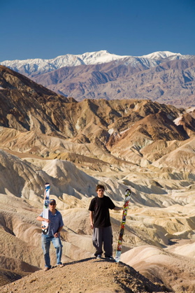
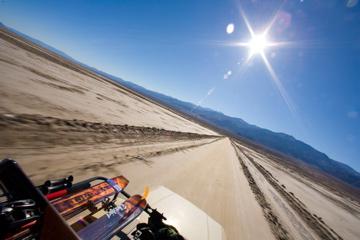
Across Death Valley, bound for the Panamints. Photo by Christian Pondella.

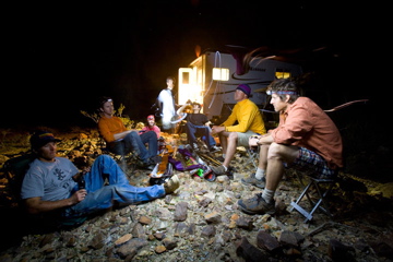
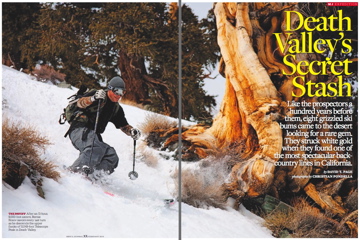
Once upon a time there was a certain utility to climbing mountains: to get the lay of the land, to see which way to run the wagons, to be the first to do it. That time is gone. And yet there we were, on a long haul to the top of the biggest mountain in the lower 48, in the dark, with skis on our backs.

[Author’s note: for the glossy mag version, check out the February issue of Men’s Journal, the one with Mel Gibson on the cover, or read it online here.]

1:05 AM; 1,609 feet above sea level; 1,891 feet above Badwater

I’ve been asleep for maybe twenty minutes when I smell coffee. The lights are on in Boyer’s camper. Orion is still midway through his long, slow face-plant over the tail of the Panamints. We’re into the second hour of March, at almost nineteen hundred feet above the lowest, hottest, driest basin in North America, and it’s a balmy 65 degrees. A warm wind sweeps down-canyon bearing only the faintest memory of winter.

It’s been an hour since John Wentworth arrived Paris-Dakar-style out of the moonless desert night, fresh from a day of mid-winter “pow” in the High Sierra backcountry. (Later, he will show us pictures on his phone, as if to reinforce the depth of our folly.) “Where’s the snow?” he asked.

Dry camp, Hanaupah Fan. Photo by Christian Pondella.

If I hadn’t seen it with my own eyes, hadn’t seen Ryan Boyer (our token redneck tele guy) and Bernie Rosow (our token jibber) posing with fat skis on their shoulders — at Dante’s View, at Zabriskie Point, on the boardwalk at Badwater, after breakfast yesterday, with the mercury already pressing ninety degrees, the tourists looking on disbelieving, the snow-dusted crest of the range painted above our heads like some ineffectual wisp of cloud (“How do you get up there?” asked one; “What if someone breaks up?” asked another) — I wouldn’t believe it existed, or that we might be able to ski on it.

Telescope Peak, at the summit of the desolate Panamint Range, is the highest point in Death Valley National Park, two dry ranges into the rain shadow of California’s Sierra Nevada. By the Köppen Classification System its summit — rising as it does from below sea level and only barely grazing the troposphere, somewhere up there in the night sky — is but a tiny oasis of cool “Mediterranean” climate (read: occasional snow) marooned atop a much larger island of so-called “arid mid-latitude desert,” floating, in turn, in a vast sea-bottom of “arid low-latitude desert (hot)” that stretches deep into Mexico.

“Telescope towers above the land at its foot as does no other peak in the United States.”

— W.A. Chalfant, Death Valley: The Facts (1930).

Early in the winter of 1849, a hardy Wisconsinite by the name of William Manly, scouting for a ragtag, dehydrated, half-starving convoy of California-bound emigrants, followed the distant vision of “the lofty snowcapped peak” for two months, like the North Star, across the wasted basins and hard-rock ranges of southern Nevada, across what is now known as Area 51, across the unrelenting flats of the Amargosa Desert, through the Funeral Mountains to the springs at Furnace Creek.

“A hoard of twenty dollar gold pieces could now stand before us the whole day long with no temptation to touch a single coin… We would have given much more for some of the snow which we could see drifting over the peak of the great snow mountains over our heads like a dusty cloud.”

— William Lewis Manly, Death Valley in ‘49 (1894).

Zabriskie Point. Photo by Christian Pondella.

The day after Christmas — celebrated with boiled ox and coffee — he awoke to find the mountain, and the good water it might represent, still more than twenty miles away across the barely-passable surface of one of the largest salt pans in North America. And even more of a barrier than he’d imagined.

“Nothing could climb it on its eastern side,” he wrote, “except a bird.”

2:15 AM; 3,200 feet

We’ve crawled our two hardiest vehicles into the gutted, dust-dry larynx of Hanaupah Canyon’s South Fork, in the dark, abandoning them when they could go no farther.

We’re on foot now, picking our separate ways up the wash, eight men into the warm katabatic breeze, into the tangle of willows, into the riot of frogs up-canyon, on and up, headlamps bobbing and dipping across the night like drunken fireflies.

We’ve foregone the park service-recommended ice axes and crampons, have left behind our avy gear — shovels, probes, beacons — in the interest of traveling as light as possible (which is not very light, alas, with skis, skins, ski boots, food, winter clothing, and nearly a gallon of water each on our backs).

My brother-in-law, Devin McDonell, whose headlamp is all but dead, claims the first spill: a turtle-dive flat on his face beneath the full weight of his pack. Joe Walker, ex-pro ski racer, accomplished world traveler, ski tuner for the World Cup, has forgotten his hiking shoes — but is happy as ever dancing over cactus thorns in a pair of self-draining river moccasins. Rosow, with no headlamp at all, proves nimble enough in his low-top skate shoes.

3 AM; 3,400 feet

Dave Schemenauer — “Shimmy,” they call him, a big-mountain skier who has made a point of skiing something every month of the year, all twelve months, for the past fifteen years — has the map (the entire quadrangle) graven on his brain. He sniffs out something of a game trail, a timeworn Shoshone path, leading straight up from the springs. He and Boyer angle for the ridge, trotting like a pair of wild goats.

“Bulge on bulge rose the bold benches, and on up the unscalable outcroppings of rock, like colossal ribs of the earth, on and up the steep slopes to where their density of blue black color began to thin out with streaks of white, and thence upward to the last noble height, where the cold pure snow gleamed against the sky.”

— Zane Grey, March, 1919, from Tales of Lonely Trails (1922).

The rest of us clamber after, as best we can, the world now canted precipitously upward, the silhouette of the mountain rearing before us, an immense blue black wall against the sky, against that ancient configuration of distant fires now and then shot through with a satellite, or a blinking jetliner on its way into or out of Los Angeles or the Bay Area or Vegas.

Vegas spreads and grows behind us, like a stain, like dawn ever about to break. The track disappears into shale, then reappears. We make our way across broken fins of rock. The distant trickle of the springs, the cacophony of frogs far below, give way to silence — to the delicate clink-clink of gear, the scrabble of feet on scree, Rosow’s whistling, and the general singing of bowels.

Wentworth does 10-plus miles in ski boots.

Photo by Christian Pondella.

3:20 AM; 4,400 feet

The moon sneaks up behind us, a quarter moon, illuminating rabbit pellets, bleached coyote scat, carcasses of well-traveled party balloons, the tracks of some big ungulate — a deer, perhaps, or a bighorn.

3:35 AM; 4,930 feet

“Probably too early to say this,” says Boyer, strolling along a flat ridgeline through sagebrush and half-dead juniper, “but this is downright civilized.”

3:50 AM; 5,202 feet

An old fire pit on the ridge, the ground wet in patches where once, not long ago, there was snow. There are mosquitoes, and piñon pines, and mysterious bird-flutterings in the bushes.

I think about Manly and his buddy John Rogers, marching 250 miles from Death Valley to what is now the edge of Los Angeles, in early 1850 — no GPS, no maps, no real idea where they were or where they were headed, setting off with “seven-eighths of all the flesh of an ox… a couple spoonfuls of rice and about as much tea… [and] all the money there was in camp” — and then back, another 250 miles, to bring a little ration of flour, yellow beans and hope to their compatriots.

Manly was 30, Rogers 27 or 28. What did they talk about? Did they have as nuanced a sense of humor as ourselves? Could they as deftly work from the notion of ice on the planet Uranus all the way to Reinhold Messner, solo, shitting into the hood of his one-piece on an exposed face at 27,000 feet, then slopping the hood on his head and climbing two more days to the summit?

Eleven years later, in April of 1861, a Dr. Samuel George and one W.T. Henderson — prospectors for precious metals — were the first to climb to the summit of the Panamints. Mr. Henderson, who also happened to be no slouch at killing Indians, is said to have been the one who shot the horse out from under Joaquín Murrieta, who cut the bandit’s head off to show his friends, then sold it for $35.

Upon making the summit of this peak, the aging vigilante “looked off over such a landscape as can be seen nowhere else on earth,” reached into the deep well of his creativity, and “because of the vast space which the eye could cover there” named the mountain after a telescope.

Boyer gets onto how many kids we have between us — just the right number, we agree — and from there to his recent vasectomy. “Felt every sixteenth of the needle going into my nutsack,” he says. And then he pitches headlong into a shrub, garners what he describes as a “fresh vagina” on his knee.

Ansel Adams, Sunrise, Bad Water. Ansel Adams Gallery.

4:20AM; 5,453 feet

Snow! We begin to see tiny atolls of the stuff, scabbed-over like bits of discarded Styrofoam caught in the bushes. The ridgeline drops, rises again.

5 AM; 6,165 feet

Still crunching across brief allotments of wind-dried crust: five or six ginger steps across the surface, then punch through to the knees. Then back onto dirt and rock. “This is awesome,” says Bernie, only half sarcastically.

“Only six grand to go,” says Pondella, working through a bag of dried Tropical Fruit Medley, disappearing here and there to leave yet another gut-processed offering to the mountain.

Joe trades river shoes for ski boots, then goes back to river shoes. Wentworth puts on his ski boots, disappears. We assume he’s decided to sidehill down into the gully for good snow. We stay high.

6 AM; 6,950 feet

Daylight coming up fast. A vertical mile and a half below us the Wrangler Café is opening for breakfast. The first pack of die-hard cyclists is setting out on the spring installment of the Death Valley Double Century.

The Ansel Adams aficionados are in place on the boardwalk at Badwater, cameras on tripods, poised to get the shot: the first crack of sun across the snow-dusted wall of Telescope, more than 11,000 feet into the sky, reflected in the stagnant pool at the bottom of an extinct Pleistocene lake, 282 feet below sea level.

Somewhere up there, invisible to the naked eye, maybe two-thirds of the way up, where the vast alluvial mess gives way to a peppering of trees and the first allotments of snow: that’s us, with skis on our backs.

Men’s Journal, February 2010.

“I don’t think I’ve ever been this awake for sunrise,” says Bernie. “And sober!”

“This is what they invented chairlifts for,” says Devin, only half kidding.

11 AM; 11,049 feet

“Look yonder,” shouts Wentworth, gesturing into the rising gale — the grand northward march of the Sierra sixty miles away; dust storms brewing across the China Lake Naval Weapons Station to the southwest; the innumerable ranges lined up to the east like islands in a great sea of clouds. Below us — 11,300 feet down now, and some seventeen ragged miles overland — lies the barely-fathomable Valley of Death, and our cooler of cold Tecates.

“It was the picture of a desert, but if it be true that a picture is masterful in proportion to its power to stir the emotions, then the picture from that peak of the Panamints is not to be compared with any tawdry scene that needs the colors of vegetation to make it attractive.”

— John R. Spears, Illustrated Sketches of Death Valley and Other Borax Deserts of The Pacific Coast (1892)

We strip our skins, make fast our packs, make a brief series of calls home on Joe’s satellite phone. Then, without any great ado, we drop in.

Community Connection

For more far-out destinations across California and beyond, check out this photo essay of California’s Most Spectacular Deserts, or The 8 Best Treks in California, or The 5 Best Places to see Ancient Rock Art.

What’s the unlikeliest place you’ve ever skied? Tell us about it below.

Discover Matador