7 of the best off-road adventures in America
For any traveler, a road trip is a rite of passage, and hitting the highway is a classic way to see America’s big cities, small towns, and all the oddities in between. But for a singular type of traveler — the kind of road-tripper who’s willing to leave the road itself in the rearview — America offers a much wilder kind of adventure.
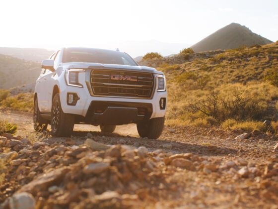
Luckily for them, this is still a land of rugged backroads. With a vehicle like the GMC Yukon AT4 and the guts to hit the gravel, you can get your family — and even your Airstream — to untouched, unbelievable places. Just remember: While the list below highlights some of the best off-road destinations in America, on most of these routes, the real fun is in getting there.
New Mexico’s State Road 6563 — aka the Sunspot Scenic Byway — is 15.5 miles of asphalt that’s never, ever a straight shot. Not even for an inch. Winding through the Sacramento Mountains and Lincoln National Forest at some 9,000 feet, far from the desert heat below, it doesn’t take you to the sun. But it sure does get you close: There are two national observatories at the byway’s southern end, and lookouts along the way approach some of the state’s longest views. (Celestial nerds will note that 6563 Angstroms is the wavelength used to identify active areas on the sun.)
You’ll begin on Sacramento Canyon Road, just east of the tiny village of Sunspot. SR-6563 winds past sky-high views of White Sands National Park, along the edges of pine-clad peaks, through aspen and fir groves, and to plenty of hiking trails. Take the Sunspot Highway all the way to Cloudcroft — named for the foggy puffs that routinely surround it — and then head north along the backroads of the Mescalero Reservation (stop at the Mescalero Cultural Center if you get the chance).
Some 30 miles later, you’ll emerge just south of Ruidoso, arguably the country’s next digital-nomad hub. Weave along the outskirts west of town until you hit Grindstone Lake, a mountainside watering hole great for paddling, hiking (a loop sits on the lake’s rim), fishing, boating, and mountain biking. But if you have an off-road vehicle with capability like the GMC Yukon AT4, continue north along Highway 48 into the peaks northwest of town, stopping at spots like Monjeau Lookout. Keep an eye out for wild horses — if you can take your eyes off the dirt climb.
The “Bridge of the Gods,” a steel cantilever bridge over the Columbia River between Oregon and Washington, is the symbolic start to this route — and it’s also pretty much the last pavement you’ll see for a long time. Gas up your tank in the tiny riverfront town of Stevenson, head upriver before leaving Highway 14 for the Wind River Highway, and then hang a right onto unpaved Bear Creek Road.
For the next 120 miles, gravel roads carry you over mountain passes, across rivers and streams, and through the ponderosa pines of Gifford Pinchot National Forest. The trees are dense, but vistas come often as you cruise through Volcano Row: On a clear day, you’ll see the glacier-laden peaks of Mount Hood, Mount Adams, and Mount St. Helens from a perspective most people never get.
If geology’s your thing, take a quick detour to the Guler Ice Caves, shaped by Paleolithic lava flows. The cavern’s ice formations are at their most spectacular in the spring, but it’s a worthwhile trip any time of year. Dispersed camping is available throughout the national forest, so find the perfect place to drop the Airstream and go get some real mud on those tires. Take comfort in the knowledge that the GMC Yukon AT4 makes it easy to hitch up or drop off, with “Hitch View” being one of the up to eight available camera views.1
The route ends in Packwood, just south of Mount Rainier National Park and the most epic section of the Cascades. These mountains are often called the American Alps, and after this trip, you’ll understand why.
Legend has it that Maine’s 96-mile Golden Road got its name because it cost the Great Northern Paper Company a million dollars a mile to carve this logging route through the North Woods to the Canadian border. Still privately owned but now open to the public, it’s a path into a wilderness so remote the animals you encounter — moose, beaver, black bear — might not yet have figured out they should be scared of people.
Start in Millinocket and drive 20 paved-but-pitted miles to where the road turns to dirt at Abol Bridge. Plan to park the vehicle and pick up a paddle: The west branch of the Penobscot River, crashing 15 miles through a steep granite gorge, past Mount Katahdin and beneath the Appalachian Trail, is some of the best whitewater in New England.
Once you’re dried off and back on the Golden Road, keep left at the fork near the western reaches of Seboomook Lake and detour to Pittston Farm, a historic outpost once operated by Great Northern. Today it’s a lodge and campground, most often a basecamp for hunters and anglers. It’s also got the last restaurant you’ll see for a while, so eat up.
Retrace your path and then continue along the north branch of the Penobscot toward the Canadian border, where you may encounter logging trucks headed in the other direction. Your GMC Yukon AT4 is a lot more nimble — you’ve got 10-Speed Automatic Transmission — so try to stay out of the way. Technically, after all, the Golden Road belongs to them.
The section of US-550 between Silverton and Ouray, Colorado, is known as “The Million Dollar Highway,” and it’s often called out as one of the most scenic drives in the entire country. However, it’s not the most beautiful stagecoach road built by engineer Otto Mears near the end of the 19th century.
That distinction belongs to a much more rugged route: Engineer Pass, which climbs into the San Juan Mountains to nearly 13,000 feet. A word of caution: This is a true alpine pass, and not for the faint of heart. (Like most, if not all, of Colorado’s most epic mountain roads, it’s closed in winter.) You’ll quickly get familiar with the GMC Yukon AT4’s Hill Start Assist and Hill Descent Control features.
The entrance is just off US-550, south of Ouray. The first few miles are easygoing, but don’t get too comfortable. Once the climb into the rugged alpine zone begins, the GMC Yukon AT4’s available Active Response 4WD TM system will come in handy keeping traction and control, and at the summit, you’ll be walloped by a 360-degree panorama of epic Colorado fourteeners.
The road through Engineer Pass is just 20 miles long, but there’s so much to see you could easily break the journey into a couple of days. There are ghost towns and waterfalls to explore, plus plenty of fishing, hiking, and camping all along the way. If you don’t want the adventure to end — and you’re feeling up to a seriously intense drive — continue to Cinnamon Pass to complete the “Alpine Loop” over to Lake City.
Constructed in the 1930s by the Civilian Conservation Corps, the Magruder Road goes by many names, including the Nez Perce Trail and the Montana Road. But whatever you call it, it’s the only drivable path through the largest chunk of land in the Lower 48 with no modern roads. Having features like the GMC Yukon AT4’s AutoTrac® 2-speed transfer case will help you switch in and out of 4WD as you need the capability while navigating this path.
Crossing from Idaho’s Frank Church-River of No Return Wilderness into Montana’s Selway-Bitterroot Wilderness, this is 120 miles that will transport you to the America of two centuries ago. Every vista is truly more dramatic than the one before it, and you’re all but guaranteed to spot moose, elk, and even wolves from the road and the primitive campsites along it.
After a stop at the Magruder Ranger Station, the last portion of the route takes you up and over the Bitterroot Mountains to Darby, Montana. It’s a quiet pioneer town with a couple of restaurants, but after the forest behind you, it’ll feel more like Midtown Manhattan.
There may be no landscape in the United States that feels more extraterrestrial than the abstract-art rock formations of southeastern Utah, and this drive will fool you into believing you’re alone on a desert planet — in a very, very good way.
While a constant parade of vehicles tour nearby Monument Valley, very few visitors make it out to the Valley of the Gods. You’ll be able to experience the crimson buttes and mesas — with names like Battleship Rock, Castle Butte, and Lady in the Bathtub — mostly in solitude. When you’re ready, there are plenty of dispersed camping areas to tuck yourself away, wait for the sun to go down, and enjoy some of the darkest skies in North America.
The east entrance to the valley is off US-163, the west entrance can be accessed via Highway 261, and the 17-mile road that connects them is equally grand in either direction. Once you’ve fully explored the area, know that iconic American road trip routes fan out any way you turn.
The Kentucky Adventure Tour, affectionately referred to as the KAT, is a route for those who never turn down a challenge. It’s a hodgepodge of roads built by logging and mining companies that winds nearly 1,000 miles through the central and eastern portions of the state.
For a particularly scenic section, pick up the KAT on Upper River Road, just outside Livingston, Kentucky, and spend the next hundred or so miles experiencing the very best of Appalachia. As you cruise through Daniel Boone National Forest, you’ll have to navigate some mud holes, rocky and narrow stretches of “road,” and a few creek crossings, which will be easy with the GMC Yukon AT4’s available features like Air Ride Adaptive Suspension (which raises the vehicle two inches above nominal) and High Definition surround vision1 — and it’ll all be worth it once you reach Red River Gorge.
This national natural landmark is a playground of sandstone cliffs, steep canyons, waterfalls, and natural bridges, all of which make it one of the top rock-climbing destinations in the world. You can hit a canopy zipline course, hike to some of the sandstone arches, or — if you’re looking for something legitimately unique — kayak beneath the earth’s surface, into The Gorge Underground.
When you’re ready to put in some more drive time, either take the KAT back the way you came or continue another 75 or so miles to the Mine Made Adventure Park, a reclaimed coal-mine turned off-road park, where you can let loose and really see what the GMC Yukon AT4 can do.
1 Safety or driver-assistance features are no substitute for the driver’s responsibility to operate the vehicle in a safe manner. The driver should remain attentive to traffic, surroundings, and road conditions at all times. Visibility, weather, and road conditions may affect feature performance. Read the vehicle Owner’s Manual for more important feature limitations and information.