Photo: Mirae Campbell from Why BC is the most Instagrammable place on the planet

20 Epic Hiking Spots in Southern British Columbia

British Columbia Hiking
by Carlo Alcos Nov 9, 2016

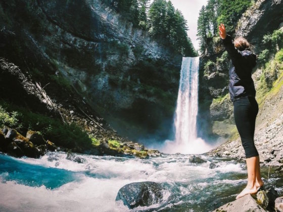
WHEN YOU LOOK at a map of southern BC you see a lot wrinkles. Those are mountains, and where you find mountains you find meadows, valleys, wildflowers, waterfalls, and alpine lakes. Thankfully there are organizations of trail builders — most, if not all of them, volunteers — that give us access to the rugged wilderness. In the summer you can be hiking in bright sunshine in a tanktop and hit snow, and in the winter the mountains become the playgrounds of cross- and back-country skiers and splitboarders, snowshoers, and ice climbers. This is but a small number of excellent hikes across the lower part of BC, spanning from Whistler to the Kootenays. Let it inspire you to strap on your boots and breathe air as nature intended it to be breathed.

All of these spots are found in travelstoke, both a social network for travelers and a crowd-sourced guidebook to the essential (and lesser-known) places of the world. Don’t see something that should be on this list? Join us on the app and add it yourself!

St. Mark’s Summit

 St. Mark’s SummitBowen Island, CanadaThis is another trail that starts off at Cypress Mountain. It is part of the Howe Sound Crest Trail. I have only hiked this during winter with my microspikes on. It made the descent that much easier. Go on a clear day to have a full view of the Howe Sound.

Stawamus Chief Provincial Park

 Stawamus Chief Provincial ParkSquamish, CanadaThe Chief is a huge granite dome that overlooks the town of Squamish and Howe Sound. This hike leads to three different peaks as well as the Sea to Sky Summit. It’s possible to do all three in a day. The fun part is you will need to climb ladders, ropes, and use chains to pull yourself up. Be prepared and don’t think of it as a walk in the park.

 Stawamus Chief Provincial ParkSquamish, CanadaWe hiked up to the Second Peak of The Chief and it was unreal. The hike wasn’t too long (maybe 1&1/2 to 2 hrs round trip) but it’s straight up (staircase style) for about 2,000 ft. The views from above are unreal! #hiking

Kokanee Creek Provincial Park

 Kokanee Creek Provincial ParkNelson, CanadaThis is the Kokanee glacier. You have to drive up a logging road near the Kokanee Creek campground to access the trailhead. This is what’s known as the Keyhole, a hike that veers off the main trail to the lake and goes up. You have to scramble up large boulders and some steep scree so it’s not an easy hike. If I remember right it took about 3 hours. #hiking

Black Tusk

 Black TuskWhistler, CanadaThis is a hike you wouldn’t want to skip. Black Tusk itself is an extinct volcano that can be seen from the Sea to Sky. The incline is not extreme. However, use caution if you do decide to take the chimney to the top.

Elfin Lakes

 Elfin LakesWhistler, CanadaA spectacular hike to Elfin Lakes take about 2-3 hours and leads to 2 lakes one of them for drinking and the other one for swimming. There is a spacious cabin there to spend the night and lots of tenting platforms. From there you can explore further and go onto more hikes in the Garibaldi Park. Absolutely spectacular hike and relatively easy/moderate too! #hiking #camping

 Elfin LakesWhistler, CanadaLocated in Garibaldi Park is a lake surrounded by snowcapped mountains. The trail ascends at a moderate grade. It is also shared by cyclists. Remember to look around you and appreciate the scenery.

 Elfin Lakes ShelterWhistler, CanadaBeautiful place to go snowshoeing in the winter, or hiking in the summer. You can sleep in the cabin, but get there early to guarantee a spot. Otherwise bring a tent. If you don’t want to overnight you can make it up to the lake in a day, winter or summer. #hiking #snow #snowshoeing #views

Christie Falls

 Christie FallsLadysmith, CanadaJust did this hike to Christie Falls in Ladysmith, south of Nanaimo. You have to walk down a logging road for a while before you get to the trailhead. This set of falls is the first one you come across, then you cross the creek on a log with roof shingles nailed to it. The hike then keeps elevating, at some parts quite steep, but it keeps alongside other falls. At the top you’re surrounded by water running down the hills, very beautiful. #hiking #waterfalls

Idaho Peak

 Idaho PeakSilverton, CanadaIdaho Peak is an easy hike from where you park and has super stunning views. The wildflowers go off in early summer so that’s an ideal time to visit. It’s not in Nelson but about an hour drive from town. #hiking

Cheam Peak

 Cheam PeakFraser Valley E, CanadaTo start this hike, you first have to drive through a forest service road. The ditches are so deep that a 4×4 is strongly recommended. This is a fairly rugged hike that leads you to a panoramic view of the Fraser Valley at the top. Be sure to go on a clear or cloudy day. Either way you won’t be disappointed.

 Cheam PeakFraser Valley E, CanadaCheam Peak was a great hike that had spectacular 360 degree views from the top. 
9.5 km roundtrip.
700 meters of elevation gain.
The road to get to the trailhead had some big ditches so a vehicle with high clearance would be beneficial.

#hiking #bc

Brandywine Meadows

 Brandywine meadowsWhistler, CanadaBrandywine meadows and peak in the early fall is an amazing place to be as all the plant life changes colors. In the past the meadows were swampy and hard to hike through but with the new boardwalks it is a lot more accessible. #hiking #camping

Joffre Lakes Provincial Park

 Joffre Lakes Provincial ParkMount Currie, CanadaThis is the most popular among the tourists. It can be done within 3 hours depending on your level of fitness. The trail is well maintained and the scenery along the way is spectacular. There’s three Glacier fed lakes, each beautiful on their own. If you were to continue you can hike all the way up Matier Glacier and be rewarded with a stunning view of all three lakes.

Mt. Gimli

 Valhalla Provincial ParkSilverton, CanadaLooking into Mulvey Basin on Mt. Gimli.

Panorama Ridge

 Panorama RidgeWhistler, CanadaThere are not enough words to describe this hike, other than the fact that you have to wait for a nice weather. It’s very challenging and need a good amount of fitness to be able to do this trail. Once you past that point you get a panoramic view at the summit of lakes, glaciers as well as Black Tusk.

Wedgemount Lake

 Wedgemount LakeWhistler, CanadaOne of the most rewarding hikes I have ever done. At 7 km, this hike is strenuous with a scramble towards the end. However, you are rewarded with an intense turquoise lake, ice caves and glaciers. It is important to be well equipped for alpine conditions, as temperatures are below freezing.

 Wedgemount LakeWhistler, CanadaA very challenging hike to Wedgemount Lake takes about 7 hours. At the top you can take a refreshing dip in the glacier lake. There is a tiny cabin at the top for campers or you can camp in your tent. One of the best hikes near Vancouver/ Whistler.

#hiking #extreme #snow #camping

Hilda Peak

 Hilda peakCentral Kootenay K, CanadaTop of Hilda Peak! One of the steeper climbs in the Valkyr mountain range. To get to the trail head, go south from Fauquier down applegrove road. After crossing past the power lines and you start driving down the big Hill take the forest service road on the left after driving past pin road. This road gets pretty skinny as you get higher up so you might just have to find a place to park and hike the rest of the way. At the end of the fsr is a cut block. At the far northeast end is a creek, if you follow that up it will lead you to the Hilda meadows. Be sure to be bear safe, as they love to hang out in the meadows! #hiking #valkyr

Pulpit Rock

 Pulpit RockNelson, CanadaPulpit Rock is a popular local hike just across the bridge from Nelson on the north shore. It’s a steep-ish switchback-y hike that takes 45 mins on average. As you can see you get awesome views back onto Nelson and into the valley heading towards Salmo. You can continue the hike another 45 mins to the Flagpole…a literal flagpole with a Canadian flag flying off it… It has wider sweeping views. The trail can get quite busy in the summer months. #hiking #rockclimbing #viewpoint

Strathcona Provincial Park

 Strathcona Provincial ParkComox-Strathcona D, CanadaStrathcona is an absolute gem, with epic multi-day hikes and paddle days. This photo in particular was taken on the flower ridge trail; a pretty big day trip starting near the Ralph River campground and either ending in alpine or continuing on for a multi-day experience to a ice field and contious loop bringing you back to a fairly close trail head. The trail is mostly steep, but enjoyable as there are few switchbacks. Be sure to bring trekking poles for the way down (we didn’t… Oops) #hiking #camping

Garibaldi Lake

 Garibaldi LakeWhistler, CanadaI have done this hike in summer and winter. Each one a different experience. The first 6 km are a bit tedious due to a series of switchbacks. But take your time and enjoy the view along the way. Once you reach the lake you will be in awe by the spectacular beauty of the surrounding peaks.

Needle Peak

 Needle PeakHope, CanadaLooking out towards the flatiron while heading up Needle peak. Last bit of the hike is a scramble but it’s worth the fear when you are on the top.

Tunnel Bluffs

 Tunnel bluffsLions Bay, CanadaAbout 2 hours steep hike up off the highway just past Lions Bay with great views into the Howe Sound! #hiking

 Tunnel bluffsLions Bay, Canada3 km past Lions Bay in West Vancouver is the trail head for Tunnel Bluffs. A great alternative to the Grouse Grind or the Chief. A lot less crowds and pretty fantastic views!

Discover Matador