PARK DETAILS
Sixty-five million years ago, the same immense forces that lifted the Colorado Plateau and shaped so much of the American Southwest created a unique feature known as the Waterpocket Fold. Today, Capitol Reef National Park is home to this gargantuan monocline — a “geological wrinkle on Earth” — which stretches 100 miles long, running roughly north to south down the center of Southern Utah, and forms the backbone of the park. Dotted along its path are sandstone domes, ridges (or “reefs,” hence the park’s name), gorges, canyons, meadows, arches, and bridges, giving this slender strip of our planet a seriously high concentration of awesomeness.
But to visit Capitol Reef isn’t just to walk among its beautiful and rugged country; there’s also an abundance of human history and culture found within park boundaries. From around the year 700 AD to just after 1250, the indigenous Fremont culture hunted, gathered, and grew crops in the area, leaving behind pictographs and petroglyphs on canyon walls that can still be seen today. In the late 1800s, Mormon pioneers settled the Fremont River Valley, and their culture and history can be experienced by park visitors as well.
While nearby Arches and Zion National Parks may attract the most visitors to Utah, Capitol Reef is not to be overlooked and is a great addition to your list of destinations in this amazing state.
Getting there
Capitol Reef is a 3.5-hour drive (218 miles) south from Salt Lake City along I-15, US-50, and eventually SR-24. From Moab, it’s only 2.5 hours (150 miles) along I-70 and then SR-24.
The wildest and most scenic route is via Scenic Byway 12, which passes through the cool little towns of Escalante and Boulder and connects with Bryce Canyon National Park. More information on this drive below.
When to visit
The park and campgrounds are open year round, as is the visitor center (excepting holidays). Note that the Gifford Homestead, which includes a small museum of artifacts from the early Mormon pioneers, and a small retail store selling souvenirs and baked goods, is only open from March 14 till late October. Hours run longer in the summer months.
June-to-August highs average in the upper 80s / low 90s — summer temperatures aren’t typically too extreme here. Keep in mind that it cools off considerably at night, so be prepared with layers. The area is most likely to see some rain in July and August, and snow in December and January, although precipitation is relatively scarce. There are risks of flash floods, especially in late summer / early fall; keep informed of weather conditions and don’t take any chances.
Where to stay
Many people only visit Capitol Reef for the day, but there’s plenty to explore if you stay a night or two. If you’re camping (RV or tent), the Fruita Campground has 71 sites complete with picnic tables, fire pits, bathrooms, potable water, and a dump station for RVs. Pads are first-come, first-served and cost $10/night.
There are also more rustic (and free) campgrounds in the park that have picnic tables, pit toilets, and fire grates, but no water. Cathedral Valley (six sites, first-come first-served) is about 36 miles from the visitor center, while Cedar Mesa (five sites, first-come first-served) is 23 miles off SR-24 on the Notom-Bullfrog Road.
Outside and to the west of the park, off SR-24, is BLM land for dispersed camping; this is where I stayed. It’s not very far from the entrance and is easy to spot (it’ll be on your right side if driving from the park entrance). There’s lots of open space for larger camping setups and also some shade trees for tenters.
For those not camping, accommodations and other facilities can be found in nearby towns such as Torrey (west of the park on SR-24).
EXPLORING CAPITOL REEF
Visitor center
The visitor center is a great place to start your exploration / education. Besides the knowledgeable rangers, you’ll find exhibits on the surrounding land, like a big, built-to-scale model of the Waterpocket Fold. Because of the feature’s size, it’s impossible to grasp the enormity of it from the ground; the model gives a great perspective and orients you to all the different areas of the park in relation to the fold. There’s also an orientation video that runs regularly and a bookstore.
For the kids
The Ripple Rock Nature Center is a kid-friendly interactive stop that’s close to the visitor center, where children (and you) can do things like spin wool, (pretend to) milk a cow, and make cornmeal using traditional implements. It’s open Memorial Day to Labor Day, but it’s best to check exact hours at the visitor center.
There are also several park programs offered between May and September, including guided walks and talks, children’s activities, and programs at the amphitheater. Schedules of activities can be found at the visitor center.
Fruita Rural Historic District
In the late 1800s, Mormon pioneers settled the Fremont River Valley, building a schoolhouse, blacksmith shop, and farmhouse, and planting orchards of apple, pear, peach, cherry, and apricot trees. If you’re visiting in the right season, you’re permitted to pick the fruit and eat it for free. There’s a small fee if you want to harvest more for taking with you.
The schoolhouse, built in 1896, is just off SR-24 to the east of the visitor center, and it’s definitely worth a quick stop and walk around. You can peer into the windows of the small building and see a recreated scene of desks, chalkboards, and other artifacts to get a sense of what it might have been like to attend classes.
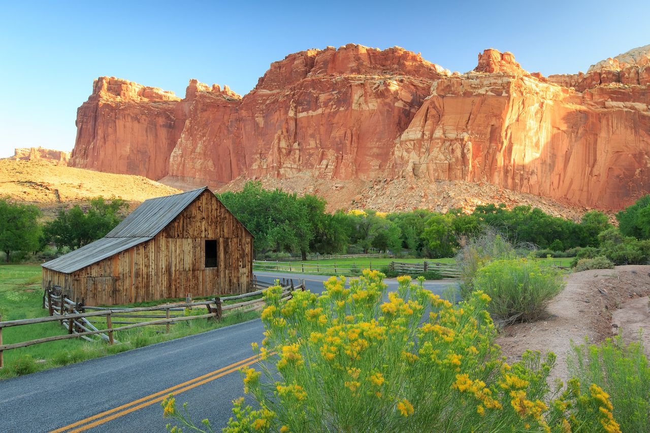
The Gifford Homestead was originally built in 1908 and today serves as a museum of antique Fruita possessions and photographs. There’s also a store where you can buy freshly baked goods, jams, jellies, homemade ice cream, and locally made kitchen utensils (reproductions of traditional household items like butter churns and flour sifters). The Giffords were the last residents of Fruita, selling off their farm to the National Park Service in 1969. There were never more than 10 families living in Fruita at one time.
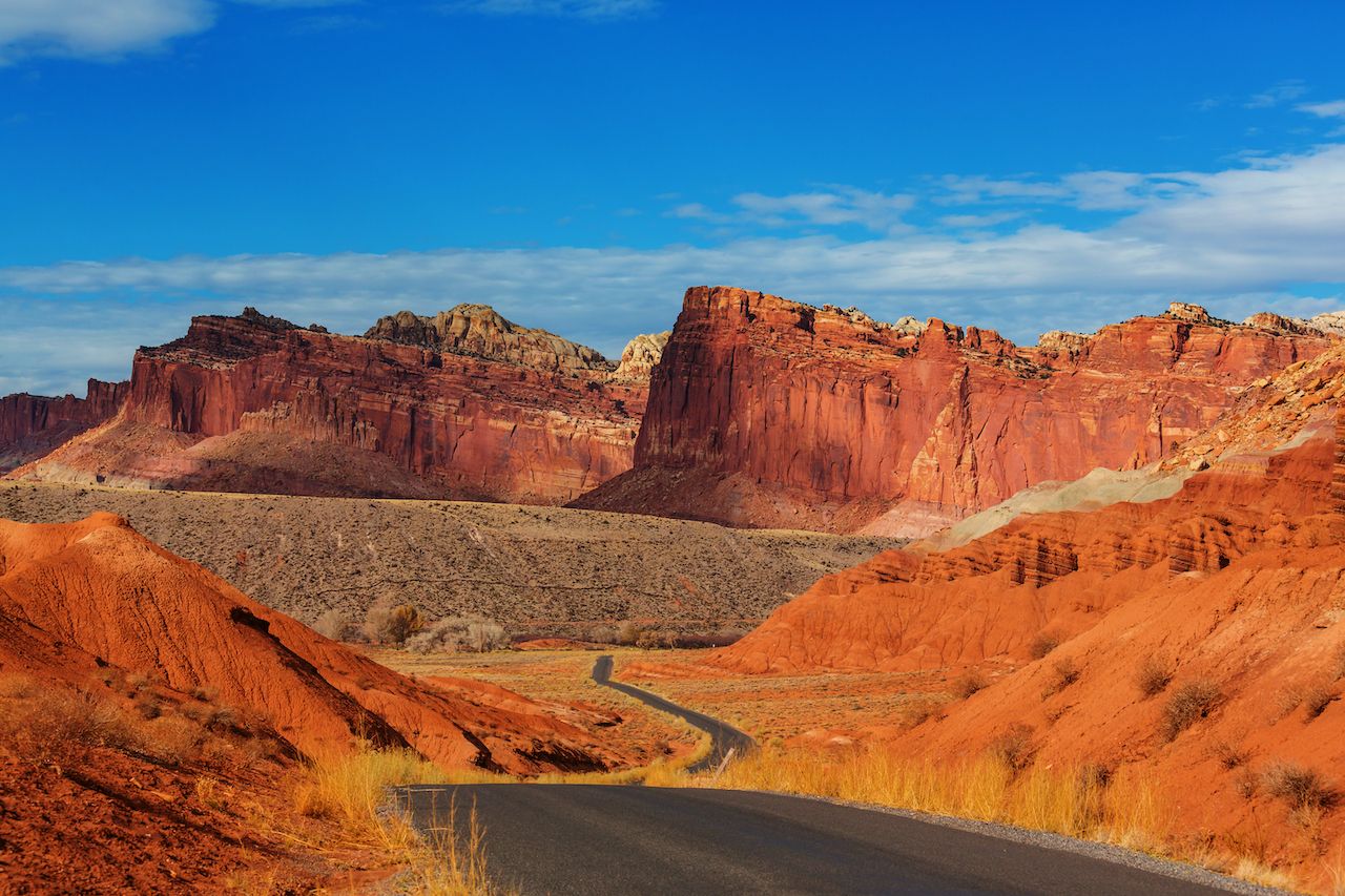
Scenic Drive
The Scenic Drive is a paved, 16-mile round-trip drive with several stops to enjoy more closely the colorful and texture-rich rock formations, canyons, slickrock, and hardy vegetation. There are two unpaved spur roads that venture off the paved route: Grand Wash and Capitol Gorge. Both spurs end shortly, but you can park and explore further on foot. Pay attention to the weather — these roads shouldn’t be traversed during rainstorms, as flash floods can occur.
Access to the Scenic Drive costs $5/car — or, if you’re arriving by foot or bicycle, $3/person ($5/family) — and is charged past the Fruita Campground. The pass is good for 7 days.
Bicycles
Riding your bike is another great way to enjoy the park (and work off some of the calories gained from those fresh-baked goods!). Keep in mind that at Capitol Reef, bikes are considered vehicles, and that means they can only go places where cars are permitted.
Hiking
My favorite method of exploration is feet to the ground. There’s a lot of hiking to be done in the park, and it’s really the only way to get up close and personal to what Capitol Reef has to offer. There are easy hikes that range from a tenth of a mile to 2.5 miles. Here’s one: After driving down Grand Wash and parking where car access ends, walk along the bottom of a steep-walled canyon and marvel at the formations on the cliff walls that have been carved by millions of years of erosion.
A great moderate trail is the Cohab Canyon hike — 1.75 miles one way — that takes you through a hanging valley and past oddly placed black volcanic rock scattered around as if a volcano blasted them out and they lay where they landed. Along the way there are a couple “fake” slot canyons you can venture down. At the end is an overlook with a terrific view of Fruita and the river valley. There’s also a steep trail with plenty of switchbacks that leads to the Fruita Campground.
If you’re looking for strenuous hikes, there are several of varying length and elevation. Navajo Knobs is 4.75 miles one way and has a 2,400-foot elevation change. The Navajo Knobs are so-named because the formations — or “knobs” — are formed from Navajo sandstone. The work it takes to reach the destination is paid with 360-degree panoramic views over the entire park.
Finally, there’s plenty of backcountry to explore if you want to get into some very remote parts of the park — gorges, slot canyons, and viewpoints from the top of Waterpocket Fold. For more details on these routes, click here. If you plan on camping overnight, you’ll need a free permit from the visitor center, and to familiarize yourself with all the rules and regulations for backcountry camping.
FURTHER AFIELD
Capitol Reef’s location in south-central Utah makes it a perfect spot to visit in conjunction with many other incredible places in the region, or as a jumping-off point for accessing more of the amazing landscapes and history Utah has to offer.
Moab
Only two and a half hours away, Moab makes an excellent base for exploring and adventuring in the area. There’s amazing rock climbing to be done — try the Fisher Towers or Indian Creek. And of course, many know Moab for its mountain biking, with world-famous routes like the Slickrock Trail in its backyard (don’t be intimidated, though; there’s tons of biking for all levels).
You can go rafting on the Colorado River or canyoneering, eat excellent food at the town’s cafes and restaurants, take in local music, and shop in the organic cooperative market. There’s a real adventuresome spirit in Moab, and you can feel it even when you’re just walking around or stopping for coffee in town.
Arches National Park
There are over 2,000 natural stone arches in this national park, the world’s densest concentration. Arches are formed by rainwater erosion of sandstone, and they’re all destined to collapse eventually. Throughout the park you can see evidence of some that have already fallen, some very recently. Besides the arches, take in views of red and orange balanced rocks, fins, and spires — it truly is an alien landscape.
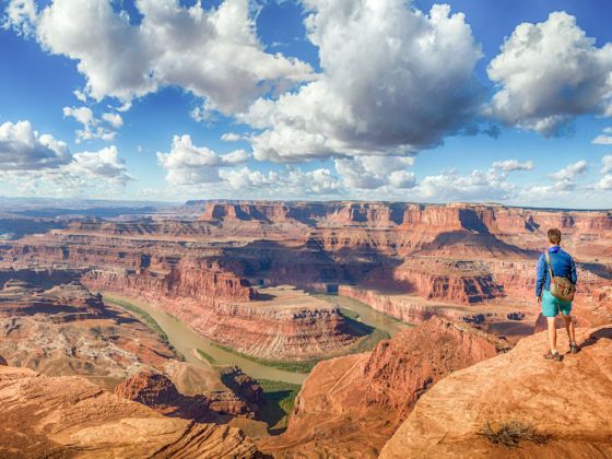
Dead Horse Point State Park
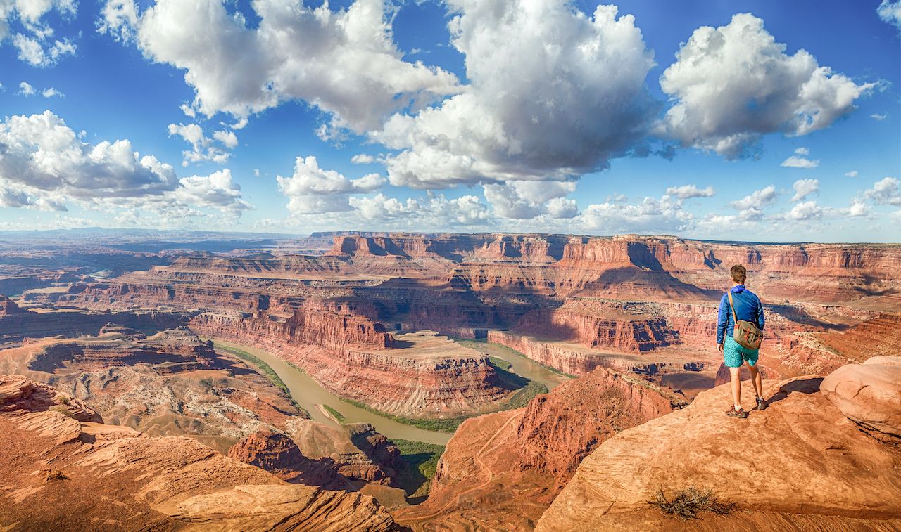
Photo: Shutterstock/canadastock
This is an excellent place to do some cross-country mountain biking and get dramatic views from atop cliffs that drop vertically 2,000 feet to the Colorado River below. Dead Horse Point gets its name from the 19th-century cowboys who used its features as a natural corral to trap wild mustangs.
Canyonlands National Park
There are three distinct land districts of Canyonlands, each with varying degrees of accessibility: Island in the Sky (the most accessible, with paved roads and viewpoints from the 1,500ft-high mesa); the Needles (more hiking, off-road vehicle access); and the Maze (least accessible with no amenities, which makes for an incredible off-the-grid experience). The Green and Colorado Rivers comprise the park’s fourth district, and an altogether different perspective on the canyons.
You can read more about the above destinations in Land of arches: Travel guide to Moab, Utah.
Natural Bridges National Monument
Under three hours’ drive from Capitol Reef, this is a very special spot, especially if you love the night sky. Besides being Utah’s first national monument, Natural Bridges was the first designated International Dark Sky Park. It’s also home to the second-largest natural bridge in the world. You can choose to either check out the bridges from viewpoints reached by a car-accessible loop road, or get a closer look by hiking down into the canyon and walking through the dry riverbed.
Grand Staircase-Escalante National Monument
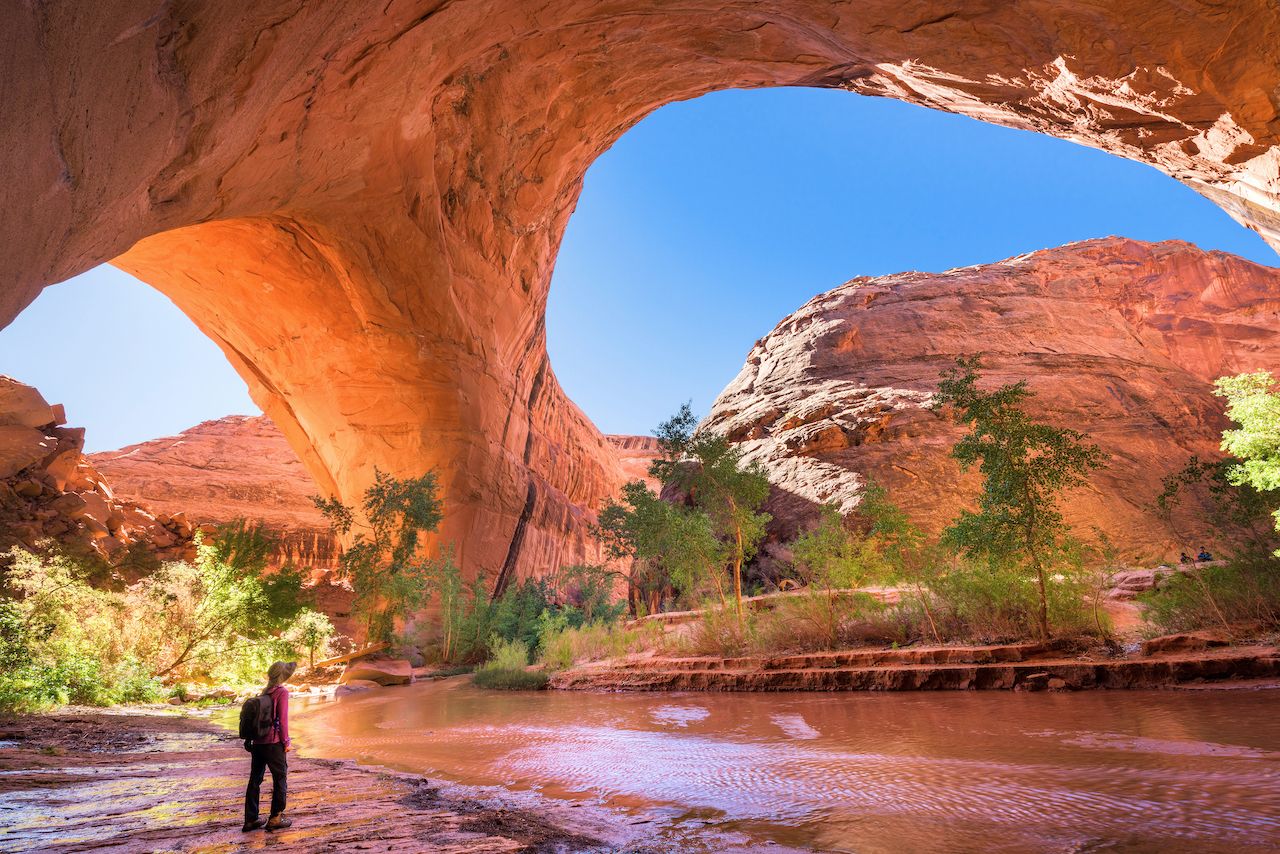
Photo: Shutterstock/kojihirano
This national monument is immense, covering almost 2 million acres with around 1,000 miles of unpaved roads for public access. (Check at visitor centers for current road conditions.) If you’re looking for more remote wilderness, this is the place to be. Exploring this area, you can find slot canyons, hoodoos, arches, bridges — pretty much every type of geologic formation that makes the Colorado Plateau what it is.
The towns of Boulder and Escalante border the national monument, connected by one of the most beautiful drives in the country: Scenic Byway 12. Between the two towns is a memorable stretch of highway called the Hogsback, a razor of a ridge atop which sits a road bordered by steep drops on either side. It’s a breathtaking few moments as you traverse this section.
Bryce Canyon National Park
At the other end of Scenic Byway 12 is Bryce Canyon National Park, a high-elevation natural amphitheater that contains the famous red-and-orange hoodoos — tall, thin towers of rock that rise hundreds of feet from the ground. Take in the amazing scenery from one of the many viewpoints, or hike down and walk among the hoodoos for a closer look. Either way, you’re sure to be flabbergasted.
For more details on visiting, check out our Travel guide to Bryce Canyon National Park. ![]()