It’s no secret that US parks have some of the best hiking in the world. They represent our nation’s physical extremes. Denali, the tallest mountain in North America, towers 20,310 feet above sea level in Denali National Park and Preserve. In the lower 48, Sequoia National Park’s Mount Whitney is the tallest peak, measuring in at 14,505 feet at the summit. Just 85 miles away, Death Valley National Park contains North America’s lowest point: Badwater Basin, sitting 282 feet below sea level. In Kentucky, Mammoth Cave National Park lives up to its name as the home of the world’s longest known cave system, encompassing more than 400 miles of passage — about the distance between Chicago and Nashville — mapped so far. Also below the surface, the deepest lake in the US can be found at Crater Lake National Park, which reaches 1,943 feet or so at its deepest point. From summiting 14,000-foot peaks, to ducking down into deep canyons and walking peaceful riverside trails, the Centennial State has something for everybody.
22+ Awesome Hiking Spots in North America's Parks
Here are some of the best trails in the country.
Editor’s note: These spots are all taken directly from travelstoke®, a new app from Matador that connects you with fellow travelers and locals, and helps you build trip itineraries with spots that integrate seamlessly into Google Maps and Uber. Download the app to add any of the spots below directly to your future trips.
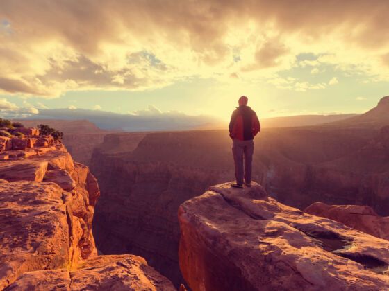
Bright Angel Trail, Grand Canyon, Arizona
Grand Canyon National ParkNorth Rim, United StatesDoes it get any better than this? #nationalpark
Don’t pack warm clothing for this hike. In the summer, it is not uncommon for temperatures to hit 110 degrees Fahrenheit at the Grand Canyon, and temperatures are even more intense on the canyon floor. Add to that the intensity of climbing nearly 4,500 feet in nine-and-a-half miles, and it’s no wonder that so many people call for rescues. Start hiking before dawn to beat the heat of the day, and pace yourself on the ascent by resting for 15 minutes for every hour. Carry and drink lots of water.
Mount Ida, Rocky Mountain National Park, Colorado
Starting at the Poudre Lake Trailhead, you’ll be above the tree-line for eight of the trail’s 10 miles. With hikers and peak baggers drawn to Colorado’s 14,000 foot peaks, it’s also likely that you’ll have much of the trail to yourself on your way to the 12,889-foot summit. It’s also recommended that you start your hike early to avoid the afternoon thunderstorms that can be common in the region during summer.
Arches National Park, Utah
Delicate Arch is the most popular site in Arches National Park, but don’t limit yourself. Devil’s Garden is a slightly primitive and lesser-traveled loop trail that follows quintessential southern Utah slickrock to not one, but a whopping eight arches in just seven miles. Summers here get unbearably hot, so try to visit in the spring or fall, and if you want to camp, make sure to book your site as far in advance as possible.
Bryce Canyon National Park, Utah
The experience of hiking Bryce Canyon is visceral and humbling, and to consider the geological forces responsible for creating this unique place is an exercise of immense imagination. The park’s series of vast natural amphitheaters (they’re technically not “canyons,” despite the name) have been etched by erosion for millions of years. Small or not, the park can afford you days of on-foot exploration, and the varying levels of trail difficulty and length mean there’s something for everyone. Below are some recommended options; click here for a full list. Note that many of the trails are interconnected, so multiple route combinations exist depending how long and far you want to walk. Also, keep in mind that these hikes take you from the rim down into the amphitheaters — it’s always uphill on the way back!
Chattahoochee River, Atlanta
The terrain Chattahoochee National Recreation Area is characterized by rich deciduous forests threaded with creeks and wetlands draining to the Chattahoochee River. The Chattahoochee National Recreation Area has extensive trail systems along the river. North of the city, my favorite hiking trails are Gold Branch and Johnson Ferry North. Although it doesn’t show it on the map, the Johnson Ferry North trails connect with historic Hyde Farm, a family farm that continued in operation (subsistence farming) even as suburban sprawl consumed the surrounding area throughout the 70s, 80s, and 90s.
Mt. Whitney, Sequoia National Park and Inyo National Forest, California
If you don’t have time for the John Muir trail you can still summit Mt. Whitney since the peak is accessible via a walk-up trail. It’s preferable to do the 22-mile round trip over several days as a backpacking trip starting from the east at Whitney Portal, though extreme day hikers and those unable to secure permits attempt the day hike every day. The aforementioned Whitney Portal Store at the campground is well-stocked. If you are attempting the day hike, buy some ibuprofen, you’ll need it for the altitude headache.
Angels Landing, Zion National Park, Utah
A trail cut into Angel’s Landing, a rock formation in Zion National Park, leads to a view of Zion Canyon. The path to the top includes 21 steep hairpin turns, known as Walter’s Wiggles, before arriving at Scout’s Lookout. The lookout is the last stop before the final trek to the top of Angel’s Landing. The final half mile, littered with narrow pathways, unevenly surfaced steps, and sharp cliff dropoffs, is equipped with chains to grip for safety. Fatalaties on the trail to Angel’s Landing have occurred, but the view and strenuous climb continues to attract hikers.
Noland Divide Trail, Great Smoky Mountains National Park, North Carolina
Clingman’s Dome, Great Smoky Mountains National Park, Tennessee
Mist Trail to Vernal / Nevada Falls and Half Dome, Yosemite National Park, California
A classic hike in Yosemite which gets crowded in the summer for good reason. A permit is necessary for Half Dome so make sure to plan ahead if you intend to go that far. Consider doing this hike in spring as there will be less people and the snowmelt will create more mist. The trail is carved into rocks close to the plunging Merced River. As you ascend Yosemite’s unique glaciated geology spreads out around you. Stock up on snacks in Yosemite Village before heading off.
Capitol Reef National Park, Utah
Sixty-five million years ago, the same immense forces that lifted the Colorado Plateau and shaped so much of the American Southwest created a unique feature known as the Waterpocket Fold. Today, Capitol Reef National Park is home to this gargantuan monocline — a “geological wrinkle on Earth” — which stretches 100 miles long, running roughly north to south down the center of Southern Utah, and forms the backbone of the park. Dotted along its path are sandstone domes, ridges (or “reefs,” hence the park’s name), gorges, canyons, meadows, arches, and bridges, giving this slender strip of our planet a seriously high concentration of awesomeness.
Dante’s View, Death Valley National Park, California
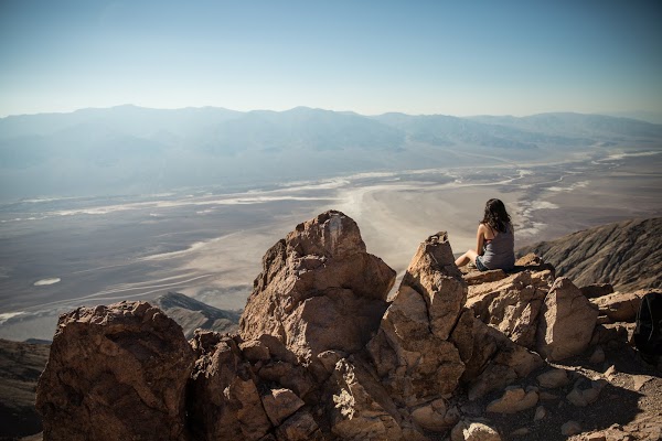
Photo: nikkivargas
If you want to get the best view of Death Valley then you need to head over to Dante’s View, the highest point in Death Valley standing at 5,000 feet. It’s easy enough to get to Dante’s View by car and then take a 5-minute walk to the peak where you’ll spot salt pans down below and the banded canyons and rising mountains in the distance.
Steamboat Rock State Park, Dinosaur National Monument, Colorado
The rock covers 600 acres and the trail that ascends from the base of the rock to the somewhat flat top affords hikers incredible views of the surrounding area after an initially steep ascent.
Lower Yosemite Falls, Yosemite National Park, California
This short, easy walk rewards with spectacular views of both Upper and Lower Yosemite Falls. This paved loop trail offers different vantage points of Yosemite Falls and Yosemite Creek.
Sequoia National Park, California
Little Lakes Valley Trailhead, Inyo National Forest, California
Little Lakes Valley to Gem Lakes is a 6.9 mile out and back trail located near Bishop, California.
Jenny Lake, The Tetons, Grand Teton National Park, Wyoming
Covering roughly 1191 acres, glacially-carved Jenny Lake is the second largest lake in Grand Teton National Park. At 423 feet it’s also one of the deepest.
Bechler River Trail, Yellowstone National Park, Wyoming
Bechler River Trail has everything people come to Yellowstone Park for wildlife, waterfalls, hot springs, picturesque river canyons, and great fishing. It is also one of the least visited areas of the park. That said, don’t leave getting your backcountry permits until the last second.
Camping is limited to established campsites and there aren’t many. It is also one of the least strenuous trails in the Rockies, being flat or a slight decline for most of its substantial length. It’s flat grade turns boggy in some areas, making it almost impassable until early August.
Madison Junction Campground, Yellowstone National Park
Muir Woods National Monument, California
Muir Woods is a short drive (12 miles) north from San Francisco and is a part of the Golden Gate National Recreation Area. This area has 6 miles of trails. There is a 1/2 hour loop, a 1 hour loop, and a 1 1/2 hour loop as well as longer hikes on trails that extend into surrounding Mount Tamalpais State Park.
Crater Lake National Park, Oregon
Check out the deepest lake in the US, at Crater Lake National Park, which reaches 1,943 feet or so at its deepest
Mount Rainier National Park, Washington
14,411 foot-high Mount Rainier is visible from Seattle, but climbing it is no easy undertaking. It requires travel on the largest glacier in the Lower 48 and advanced technical knowledge.
As the fifth-tallest mountain in the Lower 48, Rainer’s shadow has landscapes that include roaring rivers, vibrant meadows dotted with wildflowers, and jagged snow-capped peaks. Most hikers take nine or more days to complete the trail in its entirety, and the steep terrain suggests that training beforehand is wise. Still, there is probably no better place in America to get a “big mountain” experience with such a short approach.
For more information on climbing Mount Rainier, try the National Park Service trail descriptions or the Summit Post. ![]()