Google Earth just debuted a new feature called Timelapse that allows users to see the effects of climate change on the planet over the last four decades. The new tool combines static images with 4D effects allowing you to click through time-lapses of various climate events such as ice caps melting, wildfire devastation, urban expansion, deforestation, and glaciers decreasing in size and density.
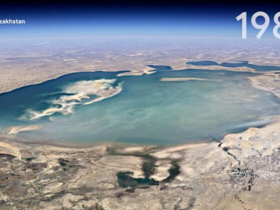
Photo: Google Earth
Google Earth’s New Timelapse Feature Shows the Devastating Effects of Climate Change
It took two million processing hours to create the interactive 4D experience and combined 24 million satellite photos between 1984 and 2020. The tech giant teamed up with NASA, the US Geological Survey (USGS), the European Union, and the European Space Agency (ESA).
Navigating the new feature is easy — users type in a location or a landmark, from the Grand Canyon to their hometown, to see how the area has changed since 1984. “Visual evidence can cut to the core of the debate in a way that words cannot and communicate complex issues to everyone,” writes Rebecca Moore, director of Earth Engine and Outreach at Google Earth. Moore continued, “We invite anyone to take Timelapse into their own hands and share it with others — whether you’re marveling at changing coastlines, following the growth of megacities, or tracking deforestation. Timelapse in Google Earth is about zooming out to assess the health and well-being of our only home and is a tool that can educate and inspire action.”
Google has highlighted a few areas of geological interest and has produced a series of videos demonstrating the changes in the specific environments. These include the shifting coastline around Chatham, Massachusetts, the eruption of Mount Pinatubo in the Philippines, and the shrinking of the Aral Sea in Kazakhstan. ![]()