IT DOESN’T MATTER how you make your way across Glacier Country — north to south, east to west, or a bunch of circles and zigzags to make sure you see it all. Remnants of the Old West and far-flung wilderness outposts will supply you with countless reasons to get out of the car. You can lose yourself in wilderness areas the size of Delaware, explore old mining towns staying true to their swaggering pasts, or check out top-notch folk music festivals, live theater, and craft brewery tours.
Here are five stops to make as you crisscross the state — a road-tripper’s dream where backcountry roads still have wash-out warnings, and where hikers, bikers, paddlers, and horseback riders can journey endless miles of trails through undisturbed wilderness.
1. Getting a bird’s-eye view of Missoula
Missoula is often called the cultural anchor of the state and is home to the University of Montana. To mark the university’s significance to the city, a white concrete letter “M” is perched above town on the west face of Mount Sentinel. It’s not the world-famous Hollywood sign, but it’s worth the hike and the photo-op.
University students have been climbing this zigzagged trail — roughly a dozen switchbacks and more than 600 feet of elevation gain — since 1908 when the first group of hardy forestry students forged a path through the bush and arranged a pile of rocks into an “M” shape. Nowadays, the trail is well established and the views get better as you climb — locals have been known to bring a pair of binoculars for a good look at sold-out Montana Grizzly football games, but they also work well for bird watching or getting a better idea of the lay of the land.
Get there: The trail starts at a parking lot on Campus Drive, across from Aber Hall at the University of Montana. The trail to the right leads up to the “M.” It’s about 45 minutes to an hour to make the trip, but it’s not complicated to continue up to the high-water mark on the face of Mount Sentinel. (Some 13,000 years ago, during the last ice age, the whole valley was under the icy waters of Glacial Lake Missoula.)
When you return, relax downtown at Break Espresso (a coffee shop buzzing with college students — once you snag a seat, you’ve got a kitchen table and a lamp all to yourself), or grab a pint at a local pub like Draught Works Brewery, which has a rotating selection of craft beers on tap.
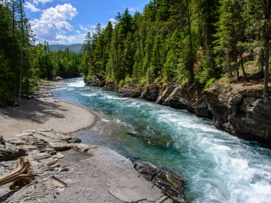
2. Exploring Ten Lakes Scenic Area in Kootenai Country
The only thing better than one glacial lake is, probably, ten glacial lakes. Ten Lakes Scenic Area is in the Kootenai National Forest in Kootenai Country, located in the far northwest corner of the state. A rest stop along the Pacific Northwest Trail — a 1,200-mile trek that runs from the Continental Divide in Glacier National Park to the Pacific Ocean at Washington’s Olympic National Park — Ten Lakes Scenic Area is nearly 15,000 acres of hiking trails, campsites, and wildlife. Of course, you don’t have to hike the 1,200 miles to stop in for a visit.
It’s hard not to conjure up classically idyllic images of wilderness reading hiking directions like these: “From the Bluebird Basin trailhead, climb through huckleberry-laden forest to Paradise Lake.” There are 89 miles of trails to stretch your legs in this wilderness area, which was first designated a “scenic area” in 1964.
Get there: Ten Lakes Scenic Area — 20 miles off Highway 93 via Forest Roads 114 and 319 — is basically the farthest north you can get before needing your passport to get into Canada. Note: If you have the time, crossing the state by driving the length of Highway 93 from south to north is worth it, as it weaves through the Bitterroot Valley, past the cultural hub of Missoula, along 185 miles of Flathead Lake shoreline, through the ski town of Kalispell, and eventually north to the quiet isolation of Kootenai Country.
3. Driving the Seeley-Swan Valley
The Seeley-Swan Valley, buttressed by peaks and hills on both sides, is dissected by a roughly 90-mile stretch of Highway 83, and runs from one lake, Seeley Lake, to another, Swan Lake, with many more in between. Lucky for you, this highway isn’t a major thoroughfare, and it lends itself to meandering adventures.
Just west of the Continental Divide, the Seeley-Swan Valley is pressed up against the Bob Marshall Wilderness Complex, which is 1.5 million acres of pure wilderness: no gas stations, no industry, no roads. Locally referred to as “the Bob,” it’s named for a conservationist from New York who served in the Forest Service in the 1920s. The Bob is home to many elusive critters, including the wolverine. There are thought to be only 300 left in the Lower 48 states, and they need a large area like the Bob to roam around in, as they can travel up to 15 miles each day in search of food. Sightings are rare, but possible. Look for a really big weasel with long claws.
Get there: The Seeley-Swan Valley is located about 30 minutes northeast of Missoula along Highway 83. Budget a couple of hours to drive this lesser-traveled road, and plan to stop at the many waterfalls, lakes, and generally beautiful spots along the way.
The Bob is accessible only by trail or the backcountry Schafer Meadows landing strip. Even if you just dip into the edge (e.g., via the 3-mile round-trip hike to Holland Falls), it’s worth it to experience the third-largest wilderness complex in the US.
4. Touring the Museum of the Plains Indian
Montana is a state with a rich history of cowboys, mining, and Old West culture, but the Blackfeet people were here thousands of years before any of that. Stop off at the Museum of the Plains Indian in Browning, Montana, in the middle of the 1.5-million-acre Blackfeet Reservation, for a taste of millennia of culture, stories, and life on the land.
The museum itself contains art and crafts created by tribal peoples from across the Northern Plains. Check out displays on beadwork, traditional dress, wood carving, and the history of the area. The museum also hosts screenings of Native-focused films and documentaries.
Get there: Browning sits east of Glacier National Park on Highway 89. Drive south from St. Mary to explore the expansive Blackfeet Reservation, or head north from the state capital of Helena.
5. Taking on the Going-to-the-Sun Road
Each spring, snowplows clear the winter’s snow pack from this narrow mountain highway that crosses the Continental Divide at an elevation of 6,646 feet. They plow 80ft snow drifts, peeling each layer of snow back like the skin on a potato, navigating around corners and looking down on sheer cliffs that drop hundreds of yards to the valley bottom below.
By about mid-June (though timing can vary year to year), the road is ready for visitors. The Going-to-the-Sun Road is the most efficient, and probably the most exciting, way to drive from one side of Glacier National Park to the other. It’s a glorious route; the views stretch for miles over green valleys edged by towering peaks, like bleachers overlooking a coliseum. Patient travelers can leave their vehicles at the summit at Logan Pass and hike the Highline Trail, basically the hiker’s equivalent of the Going-to-the-Sun Road.
Get there: The road meanders from St. Mary on the east side of Glacier National Park to West Glacier near Lake McDonald. Driving either way is spectacular, but if you want the effect of the whole world opening up in front of you, take it from east to west.
You can also bike it during summer and early fall. The route climbs 3,300 feet over 32 miles, and the feeling of total exhaustion/exhilaration as you near the summit at Logan Pass is incomparable (as will be the lavish praise inevitably heaped on you by drivers). If you make the trip from west to east, treat yourself to a slice of fresh, homemade huckleberry pie at the Park Café in St. Mary, a mainstay in the area for visitors and locals alike. ![]()