Not every San Franciscan drives a Prius or a Tesla. Plenty go greener than that, foregoing cars altogether. And since SF is crammed onto a seven-mile-wide peninsula, there’s no room for urban sprawl, which makes it a great place to go carless. The only catch is those hills… there are so many of them! Here’s how best to navigate the city without a car:
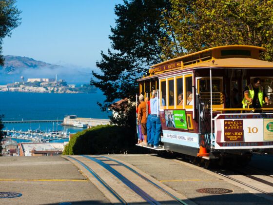
Photo: Daily Travel Photos/Shutterstock
How to Get Around San Francisco Like a Carless Local
1. Walking
San Francisco emerged as a city with the 1849 gold rush, decades before the automobile, unlike many other western US cities. That means it grew up with distinct, walkable neighborhoods, each with its own character, restaurants, bars, cafes, and shops. You can find almost everything you need in each one, usually around a commercial area that’s pedestrian-friendly — in other words, not on a steep grade.
The Mission’s Valencia Street, the Marina’s Chestnut Street, Noe Valley’s 24th Street, Haight Street, and the streets of Hayes Valley are all mostly flat. Pac Height’s Fillmore Street is on a slope, but you’ll be so busy window-shopping you won’t notice the effort. So, if you just plunk yourself in a neighborhood, you’ll find everything you need in one, stroll-able place. If you want to walk between neighborhoods, you might consider hiking boots.
2. Biking
San Francisco has been called one of the most bike-city friendly cities in the country. Rush hour on Market Street is an endless stream of bicycles. The city has been scrambling to make roads more cycle-friendly by adding green bike lanes along major thoroughfares, some of them separated by pylons from the rest of traffic. Google Maps will show you a good bike route, or you can check out the city map of bike lanes here. You can also buy a $4 walk/bike map from the SF Bike Coalition, or become a member and get it for free.
If you don’t have your own bike, the bike sharing option Ford GoBike has over a hundred bike stations in SF, with more coming. You can download the app or use a Clipper card (more on that below) to pick up the bike, ride it, and drop it off at another bike station. And they really do want you to drop it off as soon as you’re done riding, so the $3 rate is for a 30-minute trip only. ($9.95 gets you unlimited 30-minute trips throughout a day, and for $149 you get unlimited 45-minute trips all year.)
Ford GoBike Stations are clustered along Market Street, the Mission, Noe Valley, Nopa, Hayes Valley and the Haight. There are none on the north side of town so far (maybe because that’s where the Tesla drivers are), so if you were planning a ride across the Golden Gate Bridge or some other scenic endeavor, rent at tourist-oriented kiosks like Parkwide Bike Rentals & Tours. Parkwide rents in Golden Gate Park or on the Marina Green, from where you can ride along the bay and over the bridge. Rentals rates start at $32/day and go up from there; with discounts for reserving online.
Just remember that in Bike vs. Car, Car wins. So be careful, let cars know if you’re turning, use a light or at least a reflector at night, and wear that helmet!
3. Bikes with a boost
JUMP started scattering electric bikes around San Francisco sidewalks in 2017. The Jump Bikes have a built-in GPS, so you can use your app to find where one is, get on, and drop it off somewhere else. They’re $2 for 30 minutes, and that electric boost sure helps with those damn hills.
4. Bus
Locals call all SF buses and trams “Muni,” for the name of the agency that runs them, the SF Municipal Transportation Agency. For our purposes, though, I’ll split them up here. You can tell buses apart from trams because they look like, well, buses — be they hybrid ones running on electricity and biodiesel or electric buses connected to wires running overhead. And buses don’t roll along metal tracks.
Look up nextbus.com or download the nextbus or Routesy app. Routesy works for CalTrain, BART, and Muni. The apps are more accurate than Google Maps if you want to know when your bus is really coming, since Muni buses will show up eventually, but not always when schedules say they will. For more on schedules and maps, you can also look at Muni’s official site here.
You can pay for an individual ticket when you hop on the bus, but your best option may be buying a Clipper Card in advance. Clipper Card fares are cheaper than paying cash ($2.50 vs. $2.75 for adults, and $1.25 vs. $1.35 for youth and seniors) and they can be used for all Muni buses and trams, as well as BART. Muni offers 1, 3, or 7-day “Visitor Passports” but you can’t use those on BART.
You can buy Clipper Cards at any Walgreens pharmacy and plenty of other places, but for a discounted youth card, you’ll need to bring a passport or birth certificate and purchase it at a Clipper Office. There are a few in SF, so look online for locations.
5. PresidiGo Shuttle
From the Embarcadero you can get to the Presidio, and get around within the Presidio, on PresidiGo, a free shuttle bus painted with pretty forest motifs.
6. Trams (streetcars and light rail)
Muni differentiates between streetcars and light rail, which are really all trams. The E and F “Streetcars” run along the waterfront from Fisherman’s Wharf to the Ferry Building, with the E continuing to the AT&T Park baseball stadium. From the Ferry Building, the F-Market streetcar runs along Market Street all the way to the Castro. It uses historic cars from around the world. It’s kinda cool to get on a 1928 streetcar that says “Milan” on the side.
The other trams — the J, K, L, M, N and T — make up Muni’s Light Rail, although locals just call them “Muni” or “the J,” “the K,” and so on. Given the choice between a bus and tram — or, ahem, “Light Rail” — I’d take the tram. They’re faster. The lines glide above ground in some spots and all run under Market Street from Embarcadero to Church Street, and you can transfer to BART at four of the Market Street stations.
7. Cable Cars
As San Francisco was busy phasing out the last few cable car routes in the late 1940s, sentimental citizens stepped in and managed to save three of the lines. Cable cars run no faster than the 9.5 mph underground cable they’re connected to, and they cost a whopping $7 one-way, so they’re more popular with tourists than locals. The Hyde-Powell Line does get you into town from Russian Hill and the California Line heads right into the Financial District, so if that’s where you’re going, they are handy and so darn iconic.
8. BART
Not talking about that bratty Simpsons kid… BART stands for Bay Area Rapid Transit, the subway that takes you from the San Francisco International Airport to downtown SF and all over the East Bay, to Berkeley and Oakland and far beyond. BART doesn’t cover as much ground inside SF as the buses and trams do, but if BART is in your line of travel, take it. It’s by far the fastest way to get from point A to B, zipping from the south end of the Mission to the Embarcadero in less than 10 minutes, for only $2 using your Clipper Card (or $2.50 for a non-Clipper, BART ticket). Plus trains come every few minutes, and you can rely on the timetables. You can bring your bike onto BART at most stations too, which makes it a great way to combine some of these non-car options. The Embarcadero, 24th Street, and 16th Street stations are pretty safe after hours, as there are usually a lot of people around. However, I wouldn’t get off at the Civic Center BART station late at night.
9. Cal-Train
There are only two Cal-Train stations in SF, downtown and in Dogpatch, but Cal-Train is a fast and reliable way to the South Bay. For locals working in Silicon Valley who don’t hop on the overly-scorned Google or Facebook buses, CalTrain gets them from San Francisco to Palo Alto in less than an hour for $6 ($5.45 with that crafty Clipper Card) and they can use Wi-Fi along the way. Until Elon Musk comes up with his Hyper Loop, CalTrain is one of the better ways to get down the peninsula.
10. Chariot
For folks with a set route they travel frequently, Chariot is another option. It’s like a large van/small bus (specifically, a Ford Transit Wagon) that has set driving routes around San Francisco. This is really best for working residents, as passes are by the month, starting at $69 for mornings only, $89 for off-peak travel, and $119 for all access travel within the city.
11. Car Sharing
If you need to get someplace that isn’t easily serviced by public transportation, there are plenty of car sharing options. Once you join ZipCar, you can access their vehicles around town, reserving them any time from a week to an hour in advance. Turo and Getaround both let you rent cars from locals and, if you do live in SF and own a car, rent your vehicle out to others when you aren’t using it.
12. Lyft
For those in the know, Lyft is the on-demand car app of choice. Maybe it’s 2AM. Maybe you just missed the bus. Order a Lyft. ![]()