Photo courtesy AllTrails

AllTrails 'Peak' and 'Plus' Review: A Reinvented Classic That Makes Everyday Adventures Smarter

Hiking Cycling
by Tim Wenger Jun 25, 2025

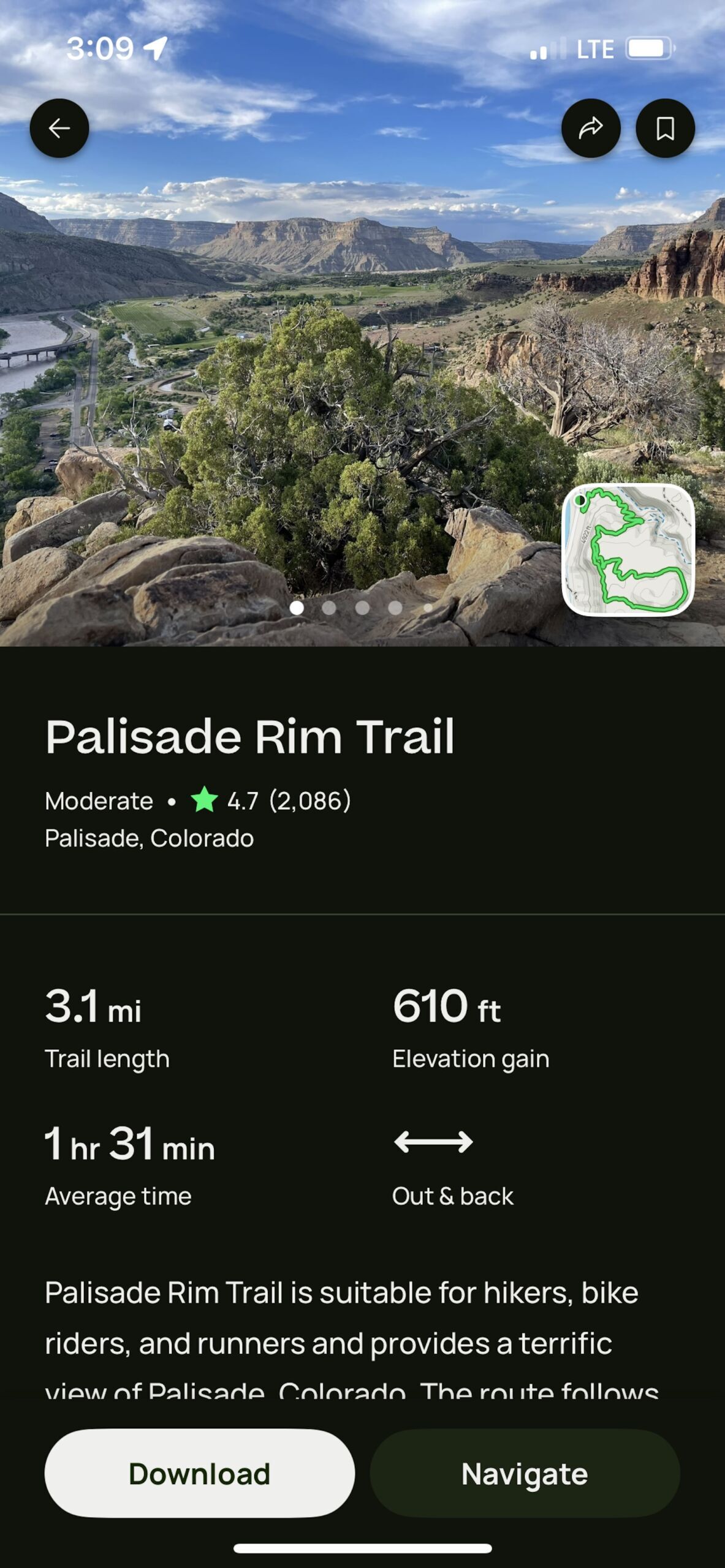
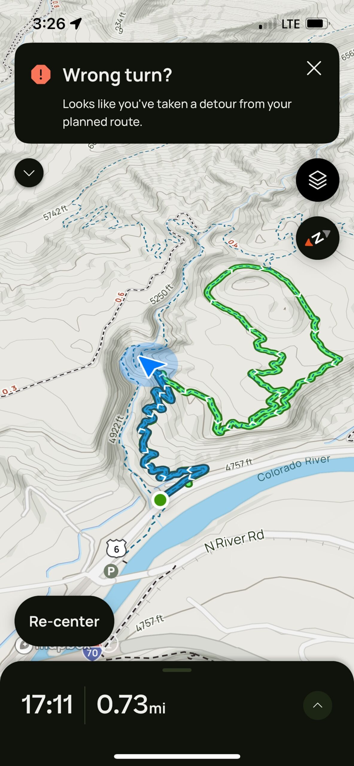
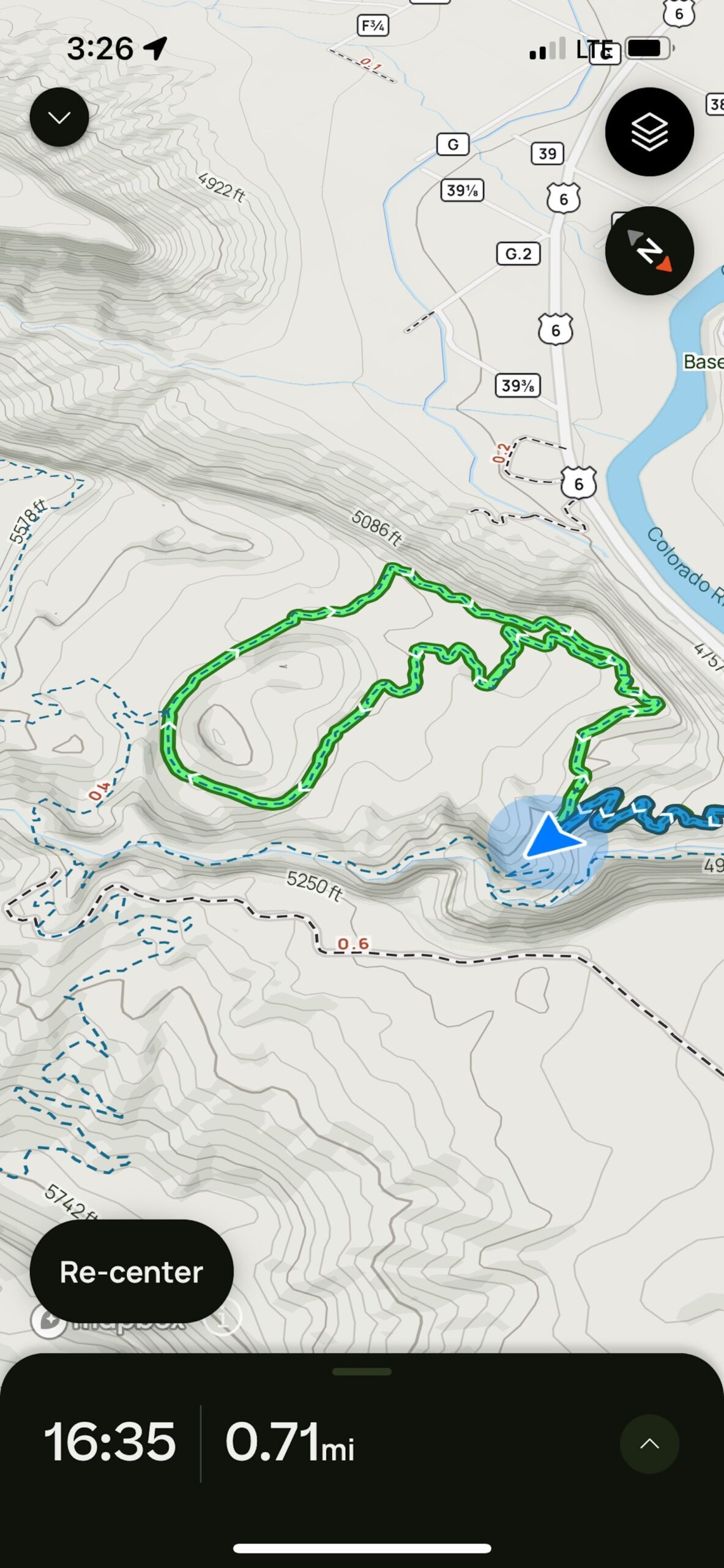
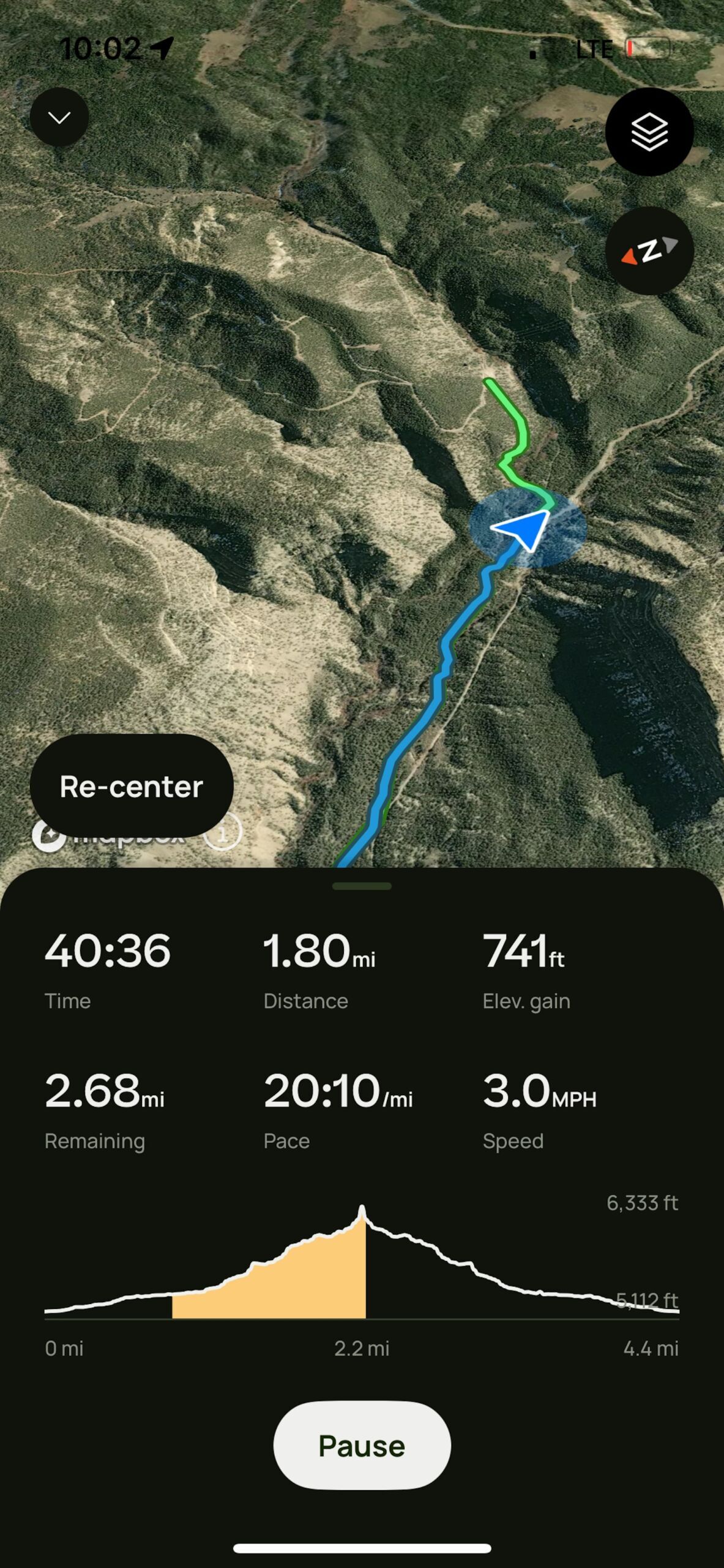
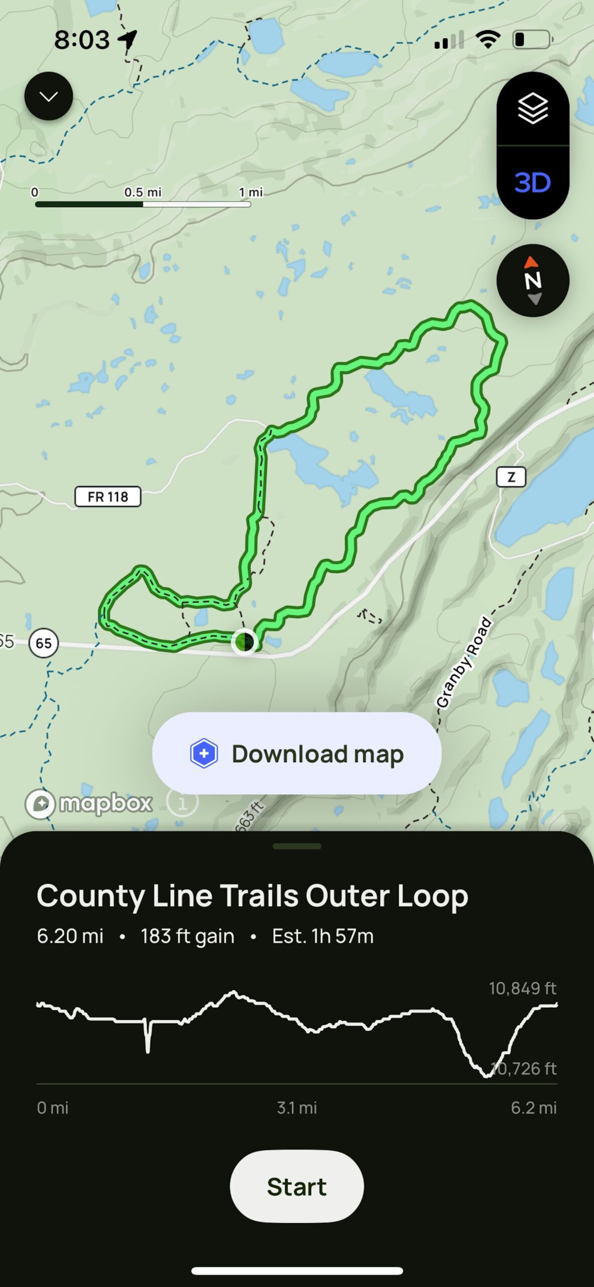
It takes a lot to pioneer a new technology. It’s even tougher to reinvent the wheel. The evolution of trip planning resources rarely sees an OG mobile app reinventing itself to top its feisty upstart competitors. At least, not successfully. AllTrails has pulled off this rare feat with its latest app updates and the launch of its new paid model, “Peak,” and lower-tier “Plus,” and for regular outdoor recreationists, the end result is more than worth the $79.99 (or $35.99 for “Plus”) annual membership. I spent two months testing the app’s new premium tier on trails around my home in western Colorado, and found the massively updated AllTrails to be an easy-to-decipher trail companion for hikes and mountain bike rides. A bit of tech savvy is necessary to get the most of the service, but the learning curve is minimal – and the return is decisive. Here’s a breakdown.

Just so you know, Matador may collect a small commission from the links on this page if you decide to make a purchase.

Sign-up or upgrade your AllTrails membership

AllTrails Peak and Plus memberships take GPS mapping to new heights

alltrails trail screen for palisade rim trail

When a trail is selected, AllTrails displays info on distance, elevation gain, and makes it easy to discern whether its one-way or a loop. Screenshot: Tim Wenger

There’s an app for each niche outdoor activity and every aspect of travel. I’ve come to trust OnX for ski touring and TripIt for itinerary building, but what I’ve historically lacked is one go-to source for everyday outdoor trip planning – finding a good trail to hike with my family or to take a buddy to on a mountain bike ride, as examples, that shows general trail information and, importantly, makes a clear distinction between when mileage listed for an out-and-back trail is round-trip or one-way.

I was a staunch advocate for GaiaGPS for five years or so until Outside bought it in 2021 and subsequently tanked the entire user experience, and my first use of the new AllTrails Plus service reminded me of a cleaner, more contemporary version of the old GaiaGPS app (back when the app actually had vital trail info and didn’t label most backcountry trails simply as “Unknown Trail”).

AllTrails went back to the drawing board to add features of more activity-specific wayfinding apps like MTB Project and put them into one place, adding a social feed to boot. I headed out for a hike on a workday afternoon (an activity I fondly refer to as an “after-worker”) to the Palisade Rim Trail just up the road from my house. I’ve done this trail dozens of times. The lower section of the Palisade Plunge mountain bike mega-trail passes adjacent to the Rim Trail, and since its 2020 opening a number of connector trails have sprung up bridging the two into a solid trail system for hikers and bikers.

alltrails in-app view

When I veered off-course, the app alerted me to make sure it was intentional. Screenshot: Tim Wenger

I intentionally veered off onto one that I hadn’t taken before. On trail, the 3D toggle provides easy-to-understand comprehension of aspect, elevation gain, and direction in the most earth-like rendering of any GPS app I’ve tried. It’s easy to move the map to different viewing angles up to 360 degrees, which in this case allowed me to look at my new course from every angle and direction to make sure it’s actually where I wanted to go.I’ve become particularly fond of the Satellite layer, which shows a Google-Earth-like satellite rendering of where you are with nuanced slope details that look somewhat like you’re viewing your current location from a drone up above. The app pinged me when I strayed off course, which I noticed, but continued on anyway. I was able to toggle it to create a new route for myself that ended back at the trailhead via a different trail.

alltrails in-app view

It’s easy to toggle the angle for a 360-degree view of where you are and where you’re going. Screenshot: Tim Wenger

Another standout feature is the Trail Journal, which allows users to take notes of their journeys for later reference – journaling in nature is certainly not a novel concept, but doing so digitally with the ability to add (and geotag) photos to go along with written diatribes increases the impact and memory of these moments by a magnitude of order. It’s also helpful for noting stuff like, “Massive fallen tree blocking trail that took me five minutes to lift my bike over,” so you can ride around or avoid that spot next time.

On that note, “Peak” users can create their own routes that bridge together multiple trails and even a bit of bushwhacking as necessary. A layer that shows live trail and weather conditions including UV index and air quality makes it easier to layer and pack appropriately. Notably, rather than a simple descriptor of “This is a highly-trafficked trail,” Peak users can see recent trail activity and, through the social feed and trail listings, see recent comments about conditions in the “Community Heatmap” section.

On both “Peak” and “Plus” versions, trails are marked and clickable, and when clicked into, a card displaying info including distance, elevation gain, and ratings is presented along with trail photos. Even mosquito activity is noted – something that comes in very handy for me when heading out on the Grand Mesa, where snowmelt feeds 300 small lakes that breed millions of the bugs each spring.

AllTrails makes it easy to check your location and trip stats

alltrails in-app view

When tracking your route, the app tells you not just how far you’ve gone, but it also displays how far you have left to go — including the route back, in the instance of an out-and-back trail. Screenshot: Tim Wenger

Another thing I love is that AllTrails displays a widget on my phone’s screen even when the screen is locked – which saves me so many times of unlocking the phone and opening the app each time I want to look at the map or see how far I’ve gone.

alltrails display on locked iphone screen

When my iPhone screen is locked, the app displays my trip data without me having to unlock the phone and open the app. Without even blocking the view of my family.
Screenshot: Tim Wenger

It’s easy to add waypoints to mark anything from trail closures or redirects to rest points or anything else that needs noting. I also did an outing on which I planned a route from scratch, starting on a trail I knew well and venturing outbound to another system a couple miles in, and make changes to it along the way. Toggling between activities like hiking, mountain biking, or backcountry skiing is done before you start tracking your route, and the interface and layers visible vary to be relevant to the mode of the day. For more niche/hardcore activities like ski touring or climbing, the app lacks some of the lost detailed aspects of OnX like listing property ownership and boundaries (so I know if I’m about to venture off public land), or layering that can show avalanche risk projected slide runout zones, but for wayfinding – the primary task at hand – AllTrails is top-notch.

The app can connect to AppleWatch to display basic info, and the forthcoming Outdoor Lens feature will enable identification of plants and wildlife through the in-app camera, with each discovery logged for future reference. Both membership tiers support AllTrails’ commitment to environmental stewardship, contributing 1% of annual sales to nonprofits dedicated to protecting the outdoors (of particular importance currently, with public lands in the US under serious threat).

AllTrails Peak and Plus are great for a variety of outdoor activities

alltrails in-app trail view

The app is great for identifying trails you didn’t know existed. Screenshot: Tim Wenger

For the final test, I used AllTrails to identify a mountain bike trail I didn’t know existed. The Grand Mesa offers hundreds of miles of trail, and one of Colorado’s most extensive networks of groomed cross-country ski trails. I was unaware that a bike trail starts at the County Line Trailhead, one of the three main trailheads for the cross-country network in winter, as it had never shown up on other wayfinding apps. AllTrails listed it as open and ready, however, so I hauled my bike up to the trailhead and pedaled off. At one point I got lost in the flow and missed a turn-off, ending up back at the road a couple miles from where I needed to be after a long downhill. The app had pinged me but I’d ignored it. However, it also routed me easily back to the trailhead once I reached the road.

One thing that took some getting used to is that 4×4 roads are displayed in a manner similar to trails, and I found myself repeatedly clicking on them looking for trail info only for nothing to happen. Uploading photos taken during tracking is doable, though they don’t appear to be geotagged automatically.

Going forward, I plan to continue using AllTrails for hikes and bike rides. Data is exportable for import into other apps or Google Earth, and vice versa – meaning if I happen to come across a pertinent set of trail data from a friend, I can import that into my app and use it as if it were my own. I’ll take that over a sloppily written on-trail text for help, every time.

Sign-up or upgrade your AllTrails membership

Discover Matador

Save Bookmark

We use cookies for analytics tracking and advertising from our partners.

For more information read our privacy policy.