The Tongariro Alpine Crossing is rated as one of the top ten single-day hikes in the world — that’s a pretty high recommendation. Located in the Tongariro National Park — a dual World Heritage Area acknowledged for both its cultural and natural significance — in the center of New Zealand’s north island, the trek will lead you 12 miles across an active volcano.
How to Hike the Tongariro Alpine Crossing in New Zealand
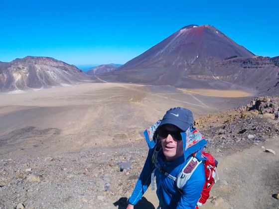
Dotted with emerald lakes, also known as Ngarotopounamu (green-hued lakes), steaming vents, ancient lava flows, and alpine terrain, this hike is full of extremes. It’s a challenging trek, beginning at 1120m. You’ll climb the Mangatepopo Valley to the saddle between Mount Tongariro and Mount Ngauruhoe, through the South Crater, and then ascend the Red Crater, the highest point on the crossing at 1886m. From there, you’ll descend through loose volcanic rocks, skirt vibrant lakes, and end your trek at 760m.
This trek can also be done in the opposite direction, but it’s most commonly done from the Mangatepopo end to the Ketetahi Hot Springs.
The climate can be extreme, the landscape unforgiving, and you’ll be exposed to the elements for the entire crossing, which will take between 6 and 9 hours. But if you’re up for an adventure, the crossing won’t let you down. One thing to consider, however, is the weather. It will make a big difference in the difficulty of the hike and if the winds are high it’s not a safe (or desired) experience.
How to get there
Located in the Tongariro National Park on New Zealand’s North Island, it’s 40 mins from Turangi and 45 minutes from Ohakune.
The Department of Conservation highly recommends visitors access the trek with a shuttle from Whakapapa Village or National Park Village.
There is a 4-hour parking restriction in place at the Mangatepopo road end for those doing shorter walks. If you plan to do the entire crossing, book a shuttle. Here’s a list of operators.
What to consider
- Take toilet paper. There are toilets on the hike, but no paper.
- Be prepared. The climate is alpine, so dress in layers.
- Bring adequate water for a challenging, 12-mile hike.
- You might want to bring walking poles and gloves, as the weather can turn suddenly.
- Check the weather conditions before you go. One of the big draws of this trek is the views, and you won’t see much if you’re fogged in.
- It’s a popular hike and is often crowded. Because of its popularity, it’s safe to do alone — you’re not likely to get lost.
