On a cold winter day in Hokkaido, the northernmost of Japan’s four main islands, a small group of us followed a narrow, snow-covered trail at the base of Mount Usu. Single file and moving on clunky snowshoes, we crossed a landscape that felt both raw and humbling. Beneath the snow was one of Japan’s most active volcanoes. One day, it will erupt again.
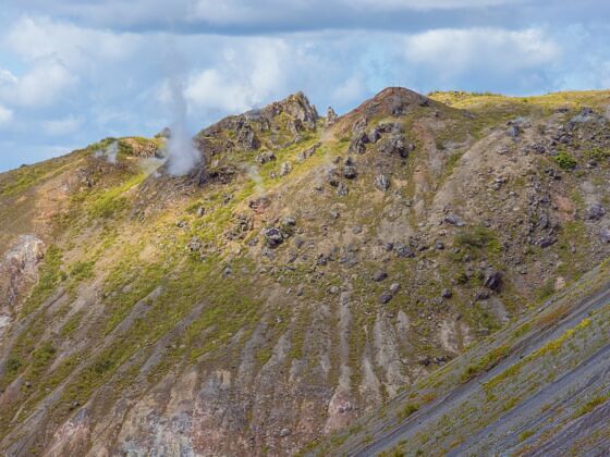
Steam vents on the slopes of Mount Usu. Photo: Guido Vermeulen-Perdaen/Shutterstock
Disaster, Preserved: Inside Japan's Living Volcanic Ruins at Mount Usu
Leading the way was Rie Egawa, founder of nature guiding service Sotoasobu and a certified Toya-Usu Volcano Meister. Volcano Meisters are trained local guides who help visitors understand Mount Usu’s geology, eruption history, and what it means to live beside an active volcano. Egawa is part educator, part storyteller, and part disaster interpreter. She moved comfortably between roles, explaining not just the disaster that struck here in 2000, but what it means to those who choose to live here.
Mount Usu erupts roughly every 20 to 50 years, reshaping the land each time. When it last erupted in 2000, volcanic mudflows ravaged Toyako Onsen, a hot springs town on Lake Toya, creating more than 65 craters — bowl-shaped depressions created when volcanic explosions release lava, ash, and gases. Roads, bridges, homes, and national highways were heavily damaged, many beyond repair.
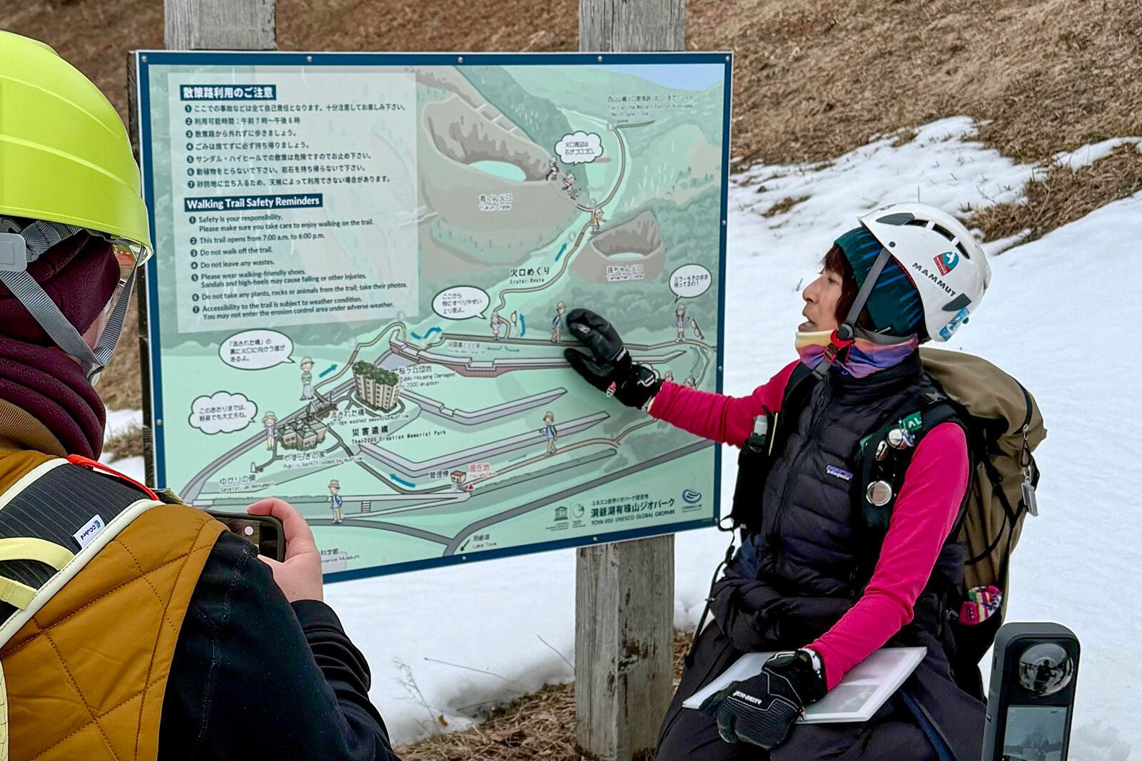
Volcano Meister Rie Egawa leading a tour of the site. Photo: Erin Gifford
“One thing I want visitors to understand is that all natural phenomena have two sides when viewed from a human perspective: both beneficial and destructive,” says Egawa via translator. “Hot springs heal and relax people, but they can also become the source of disasters, such as volcanic mudflows.”
Remarkably, no lives were lost during the 2000 eruption. Egawa explained that it was the first successful large-scale pre-eruption evacuation. Scientists tracking seismic activity picked up on early warning signs, giving residents time to safely evacuate.
A town preserving its disaster history
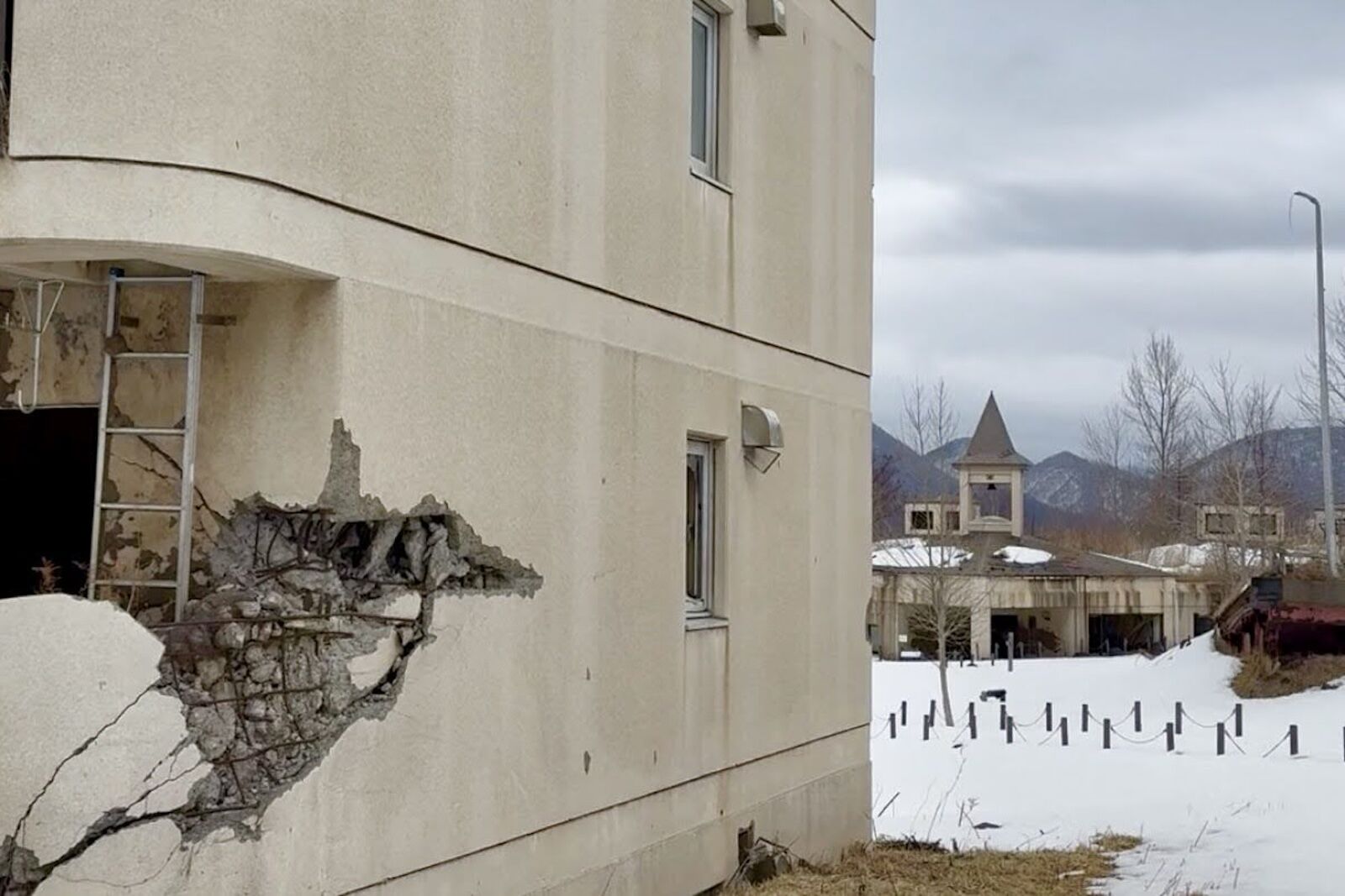
A destroyed apartment building near Mount Usu, Japan. Photo: Erin Gifford
After the eruption, officials made an unusual but deliberate decision: not everything would be rebuilt. Uplifted roads, collapsed bridges, and mud-filled structures would be left in place, to be slowly reclaimed by nature. Over time, the area became an interpretive landscape within Toya-Usu UNESCO Global Geopark, preserving the ruins to help visitors better understand the scale and impact of the eruption.
“The decisions about what should remain untouched, what should be removed, and what should be rebuilt were made through discussions among local residents, government officials, and scientists,” says Egawa. She explained that decisions balanced safety, environmental recovery, and lessons they wanted future generations to take from the disaster.
Today, visitors can explore the ruins along the 1.4-mile Konpira-yama Foot Route, one of several public trails within the geopark. The route takes its name from Mount Konpira (Konpira-yama), on the western side of Mount Usu, where volcanic mudflows once rushed through the valley carrying mud, rocks, trees, and debris. While walking the trail, I could see evidence of the eruption everywhere.
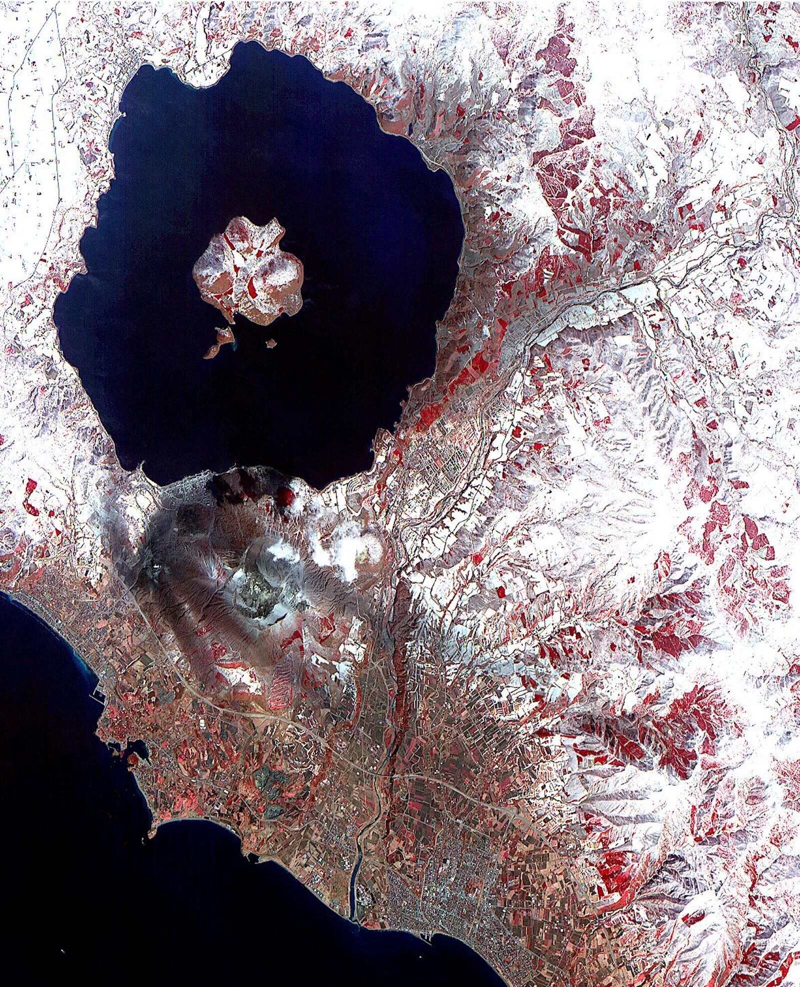
A photo from the Advanced Spaceborne Thermal Emission and Reflection Radiometer (ASTER) on NASA’s Terra Satellite of Mount Usu. The grey area shows ash from the 2000 explosion. Photo: NASA
Along the trail, a public bathhouse sat partially buried beneath dried mud, and an apartment building leaned where the ground awkwardly shifted beneath it. Sections of road rise and twist upward, lifted by underground forces during the eruption. Egawa told us that many protective structures against mudflows have been installed since the eruption, including sabo dams that help slow and trap mudflows and drainage ditches to divert debris toward Lake Toya.
The scale of the damage became clearer as we moved along the trail. Windows of homes were blown out, still-standing staircases led to nowhere, and everyday spaces were frozen mid-moment, as though someone had simply stepped away just minutes earlier.
For Volcano Meisters like Egawa, these sites are more than ruins. They are teaching tools, tangible reminders of the volcano’s powerful force and violent nature. “I hope visitors will take what they have seen and learned here back to their own communities, and develop the awareness and preparedness needed to survive future disasters,” says Egawa.
Following the path of destruction
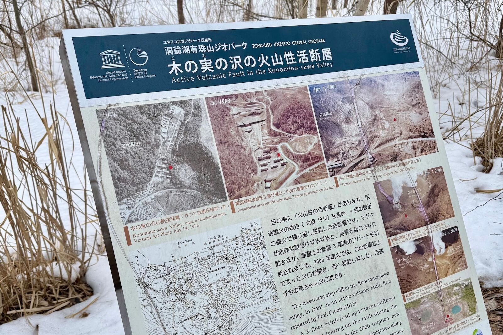
Photo: Erin Gifford
As we continued along the trail, Egawa walked us through how the eruption unfolded. In some areas, the ground slowly swelled before breaking apart. Ash built up on roofs that eventually collapsed under the weight. Mudflows surged downhill, carrying debris across roads and bridges. Each stop on our walk marked another moment in an eruption that stretched over months.
We circled the remains of the Yasuragi House public bathhouse, where the first floor remains partially buried under hardened mudflow. Nearby, an apartment building showed irreparable damage from volcanic debris.
Along the route, placards explain how bridges downstream were swept away by the force of the flows. Konomi Bridge was carried nearly 300 feet from its original location before it crashed into an apartment building, eventually coming to rest farther downstream. Nothing on the site has been rearranged or moved to enhance the visitor experience, and as we moved through the aftermath, signs explained exactly what happened in each area.
“Most visitors are deeply shocked at first,” says Egawa. “When they compare photographs from before the eruption with the current landscape and realize that people were living ordinary lives there right up until the disaster occurred, it suddenly feels very personal to them,” she says, adding that the relative recentness of it makes the impact feel even greater.
As we walked, Egawa reminded us that Mount Usu is still active, not dormant. It’s closely monitored, but it will erupt again – and that awareness shapes daily life in the region.
A landscape still in motion
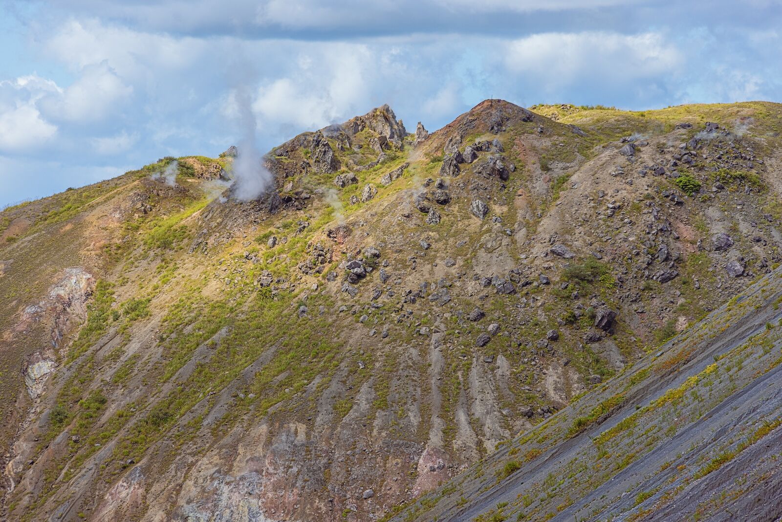
Steam vents on the slopes of Mount Usu. Photo: Guido Vermeulen-Perdaen/Shutterstock
Around 30 volcanic craters formed during the 2000 eruption remain active today, including Yu-kun Crater, one of the largest. It’s open to self-guided visitors from late April through mid-November, but only available via guided tour from mid-November to late April. Other craters sit within protected zones that are closed to the public and not intended for casual exploration or sharing on social media. These restricted areas can only be accessed on Volcano Meister-led tours, like the one I was on, which operate with special permission to guide visitors near these craters.
The experience of walking the Konpira-yama Foot Route stays with you long after you step off the trail. It was hard to fully process, standing on a volcano that once devastated an entire town, one that is still active, still closely monitored, and that will one day erupt again.
This is where Volcano Meisters have the greatest impact. They preserve not only the memory of the 2000 eruption, but also a broader understanding of how communities adapt to and coexist with an active volcano. “As long as people continue living here, they know they will likely witness at least two eruptions during their lifetime. Everyone living in this region understands that reality,” says Egawa. “At the same time, they also know that the volcano provides many blessings: hot springs, beautiful scenery, and abundant food” (thanks to the nutrient-rich volcanic soil).
As the snowy path carried us back to our starting point, it seemed like a sense of quiet reflection settled over the group. There was an understanding that Mount Usu is far more than its 2000 eruption – and that its history will continue to unfold over the coming decades. Mount Usu is still changing, and still best approached with care, respect, and close attention to a seismometer.
How to visit
Mount Usu is in Toya-Usu UNESCO Global Geopark in Hokkaido, Japan, roughly two hours by car from Sapporo. The Konpira-yama Foot Route is free and open to independent visitors from late April through mid-November. Outside those months, access is by guided tour only. To visit on a guided tour, or to access restricted zones that require special permission year-round, book through a certified Volcano Meister, such as those available through Sotoasobu.
The Konpira-yama trail starts at the Toyako Visitor Center in Toyako Onsen. Budget about 90 minutes for walking the trail yourself if you want to leave time for taking photos and reading the signage, available in both Japanese and English. ![]()