We know hurricanes are powerful enough to flood streets and destroy buildings, but this hurricane was so strong that it wiped an entire island off the map. Hurricane Walaka, an incredibly powerful hurricane, struck a small island in Hawaii earlier this month and caused it to become completely submerged. East Island, only a half-mile long, 400-feet wide, and sitting atop a coral reef, was the second-largest island in the atoll of the French Frigate Shoals and an important bastion for the local wildlife. The endangered Hawaiian monk seals used the island to raise their young, and green sea turtles and albatrosses also relied upon it for survival.
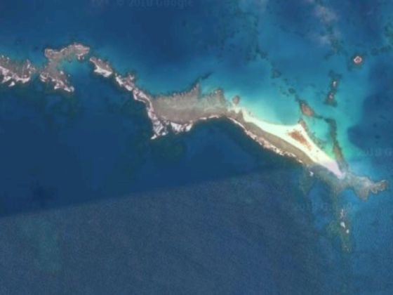
Photo: Google Maps
This Hawaiian Island Was Wiped Off the Map by a Hurricane
Scientists confirmed that the island has vanished after reviewing new satellite images. Chip Fletcher, professor of earth sciences at the University of Hawaii, told The Guardian, “I had a ‘holy cow!’ moment, somewhat in disbelief that it had disappeared. The island was probably one to two thousand years old, and we were only there in July, so for it to be lost right now is pretty bad luck.” Fletcher and his colleagues had been in the process of monitoring East Island via drone devices, and taking sand and coral samples prior to its disappearance.
Hurricane Walaka, one of the most powerful Pacific storms ever recorded, has erased East Island, which is part of French Frigate Shoals in the Papahanaumokuakea Marine National Monument. https://t.co/x9moCB1WA5 @NathanEagle #HIwx #Hawaii pic.twitter.com/BckfalPR90
— Honolulu Civil Beat (@CivilBeat) October 23, 2018
Fletcher and his team are disappointed by the loss of the island, but say that it actually teaches us a valuable lesson on the imminent dangers of global warming.
The French Frigate Shoals are part of the Papahānaumokuākea Marine National Monument. Federal managers of the monument issued a statement, promising to “continue to monitor the species and islands to better assess the impacts from the hurricane. Based on the data, managers will determine next steps and management actions.” ![]()
H/T: Inhabitat