Photo: megaflopp/Shutterstock

The 9 Hardest Hikes in the US National Park Service You Can Do in a Day

Outdoor National Parks Hiking
by Drew Baker Feb 23, 2022

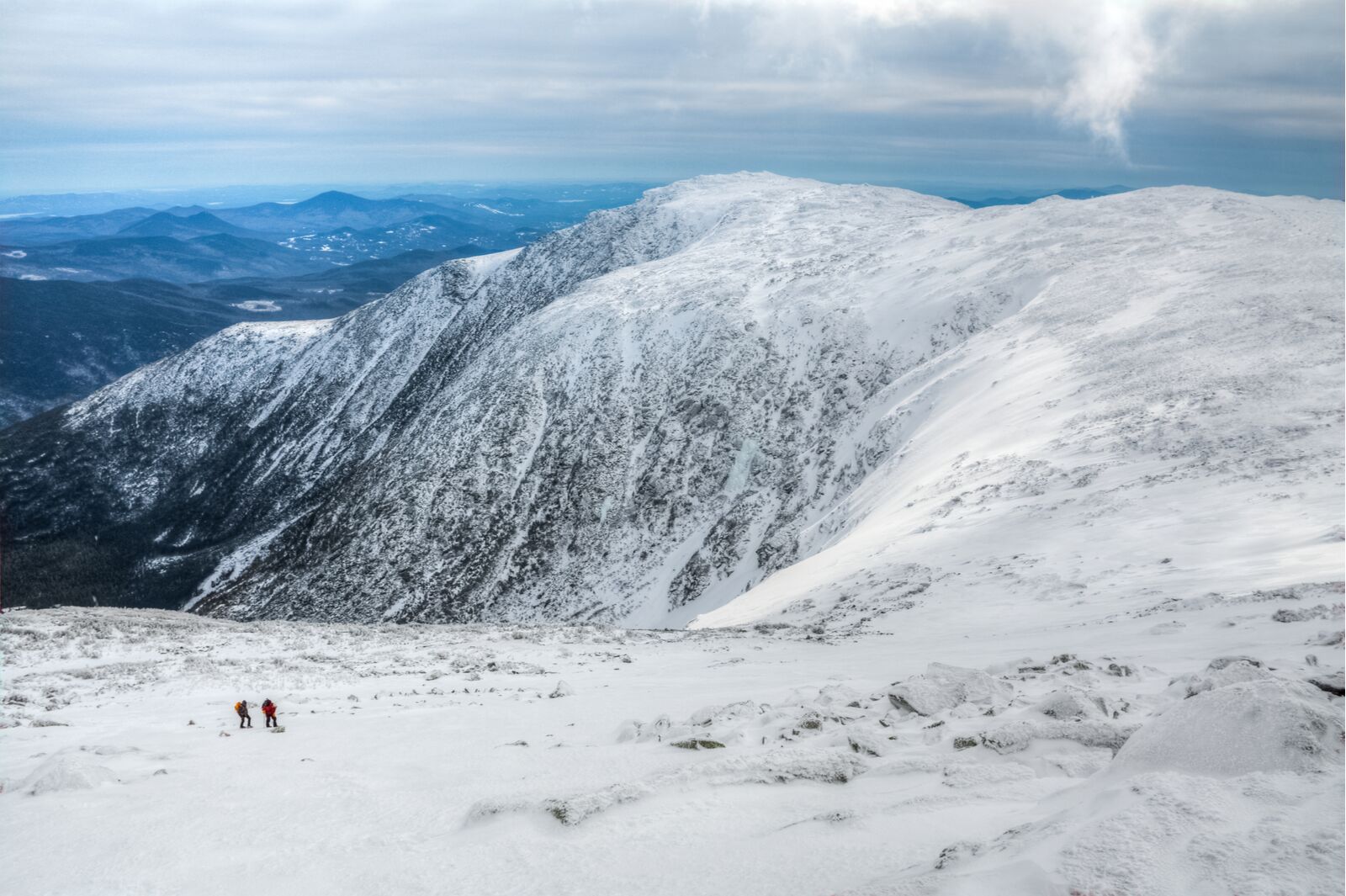
it’s no secret that the National Park Service protects some of the most fantastic landscapes and geological features in the United States. Hikers, tourists, and adventurers from across the world travel to the system’s 63 national parks to see tall waterfalls, stunning old-growth forests, and wildlife in their natural habitats.

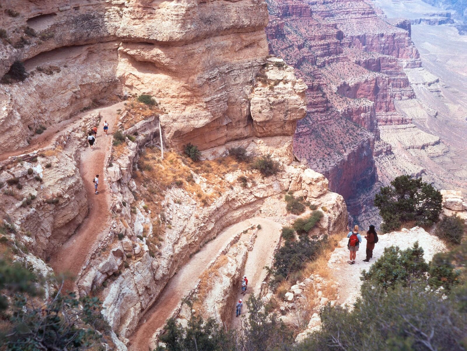
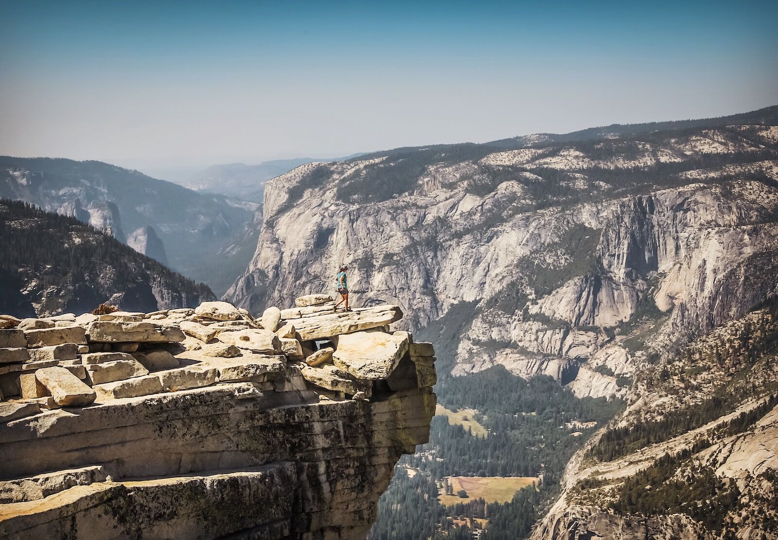
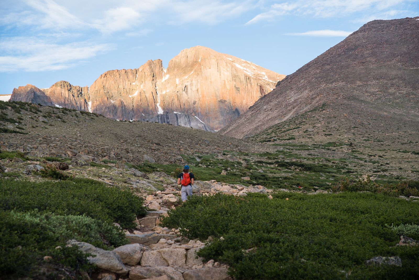
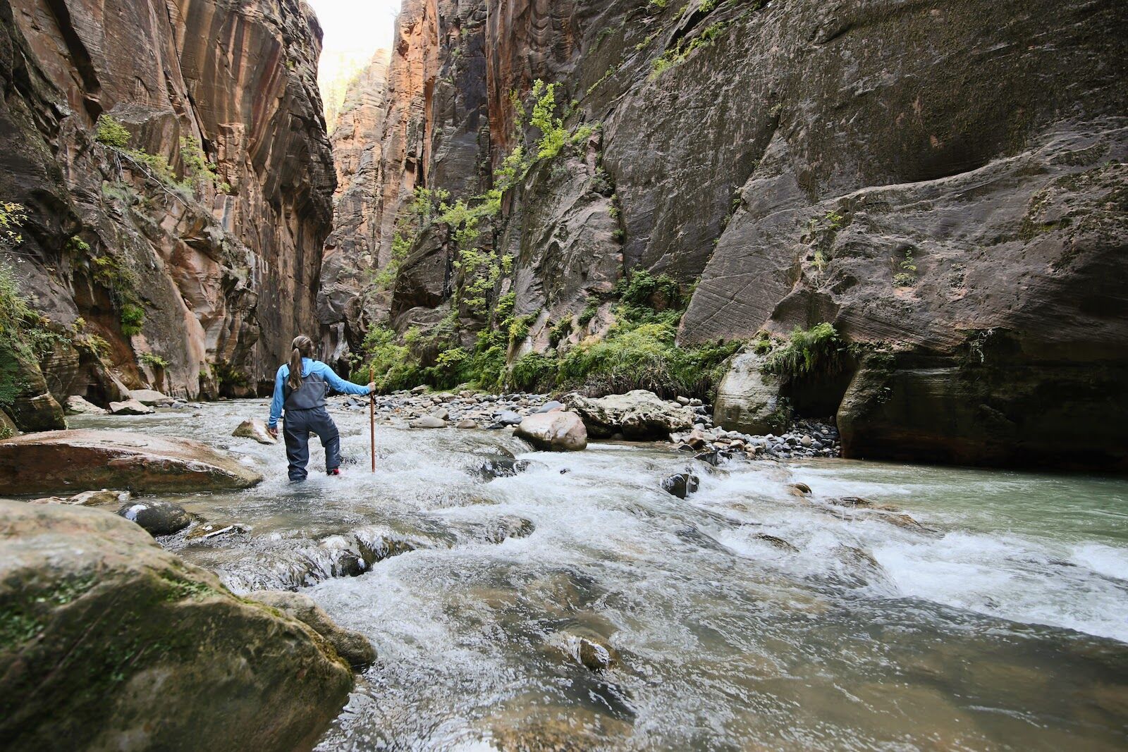
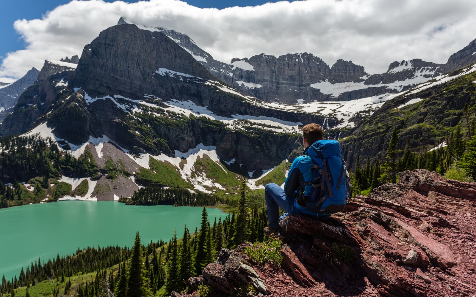
The one-mile interpretive trail behind many park visitor centers will be plenty of challenge for some travelers, which is absolutely fine. But advanced hikers who find flat trails a little lacking in excitement may need something a bit more challenging. The hardest hikes in the US’s national parks below are long, sure — but they’re also steep, unpredictable, and go through some of the country’s harshest landscapes and wildest weather. But if you’re an expert, experienced hiker searching for a hike that offers a little more (or in some cases, a lot more) challenge, here are nine of the hardest hikes in the US National Park Service you can finish in one very long day.

1. South Kaibab to Bright Angel Trailhead, AZ

The sections of trail on the south rim are some of the hardest hikes in the US

Photo: National Park Service/Public Domani

    • Park: Grand Canyon National Park
    • Distance: 16.5 miles
    • Type: Point to point
    • Elevation gain/loss: +/- 4,860 feet

The Grand Canyon is immense in a way that you can’t truly understand until you stand on its edge. But for an extra-astonishing view, you’ll need to go below the rim to see the vastness of the canyon – it’s 18 miles across, after all. But as enticing as reaching the Colorado River at the bottom of the canyon may seem, there’s no easy way down, and many hikers choose to make the trek in two or three days.

But fit travelers ready to take on one of the hardest hikes in the US may want to consider the South Kaibab Trail as a day hike. Dropping nearly 5,000 feet into the canyon, hikers will traverse what feels like a giant stairway. And canyons are different from mountains; it’s harder on the way back. For every step you take down, you’re going to take one back up.

Temperatures in the summer can reach as high as 120 degrees Fahrenheit in the canyon. Hikers attempting the South Kaibab to the Bright Angel Trailhead will find potable water year-round at only one spot – Indian Garden Campground – and you won’t reach it until you’re about 75 percent of the way through, distance-wise. Dehydration is a major problem. The National Park Service at the Grand Canyon rescued 235 hikers in 2020 alone, more than any other national park in the country. Make sure you are incredibly prepared for beginning this challenge.

2. Cascade Pass to Sahale Arm, WA

Goats atop Cascade Pass, one of the hardest hikes in the US national park system you can finish in a day

Photo: National Park Service/Public Domani

    • Park: North Cascades National Park
    • Distance: 12 miles
    • Type: Out and back
    • Elevation gain/loss: +/- 4,115 feet

The Cascade Pass trail may seem like a stroll through alpine meadows with glacier lilies, but the weather and terrain in the Stephen Mather Wilderness can change instantly, leaving hikers to trudge through deep snowfields along steep mountain ridges. However, those brave enough to tackle the 12-mile hike will find breathtaking views of features with daunting monikers like “Torment Tower” and “Cutthroat Lake.” And hikers reaching the end of Sahale Arm will find themselves looking up at a quarter-mile-long glacier.

While the trail keeps a steady pitch, most of the mountain pass is in the subalpine zone. This leaves the area exposed to heavy snow and wind. Hikers who choose to hike the Cascade Pass and Sahale Arm should also be prepared to ascend over 4,000 feet, with a big portion of that packed into the final push to the glacier.

As of this writing, the road to Cascade Pass is closed three miles from the trailhead. While still open for hiking, the closure makes this trail 18 miles long. It’s one of the hardest hikes in the US even when the weather is good, and when it’s snowy or windy, well, it’s reserved for travelers who don’t mind a little discomfort. You can recover from your hike at any of the beautiful lodges near North Cascades.

3. Paintbrush Canyon – Cascade Canyon Loop, WY

The Grand Teton Range

Photo: Dan Thornberg/Shutterstock

  • Park: Grand Teton National Park
  • Distance: 21 miles
  • Type: Loop
  • Elevation gain/loss: +/- 4,230 feet

Grand Teton National Park is home to one of the most iconic mountain ranges in the country, and the Cascade Loop trail gives you a taste of its ruggedness. The 21-mile trail includes an elevation gain of nearly 4,000 feet, and while most hikers choose to complete the hike in two days, others attempt to do it in one.

The trail begins at nearly 7,000 feet above sea level, well into the subalpine range and high enough to cause elevation sickness after just a few minutes. Hikers may face heavy winds, deep snow, and dangerous thunderstorms. Those attempting to complete the hike in a single day may want to begin this hike early (as in, in-the-dark early) to allow time to rest along the trail and avoid getting caught on the treacherous terrain in the dark.

4. The Skyline Trail to Camp Muir, WA

Mt. rainier is home to one of the hardest hikes in the US you can do in a day - to camp mnuir

Photo: Mike Peters/Shutterstock

  • Park: Mt. Rainier National Park
  • Distance: 10 miles
  • Type: Out and back
  • Elevation gain/loss: +/- 4,850

The Camp Muir Trail is only the first part of Mt. Rainier’s three-day summit. Covering 14.5 miles and gaining 9,000 feet of elevation gain, Rainier’s summit is best done in a group with a professional guide. It’s decidedly not a day hike.

But the Camp Muir Trail alone stands as one of the hardest hikes in the US to complete in a single day. It’s a challenge, with some hikers opting to bail just below the camp base. It only covers nine miles out and back, but you’ll ascend more than 4,500 feet to reach Camp Muir. However, the intense elevation gain is only part of what makes this trail so difficult.

After a strenuous 2.3-mile hike past McClure Rock (near the trailhead), hikers will enter the Muir Snowfield. Prone to white-out conditions and inclement weather, those attempting the ascent will have to navigate 2.2 miles along an unmarked route. You may need to glissade or wear crampons, and it’s possible at any time to posthole (break through the snow) with each step. With glaciers on either side, one mistake could lead to getting lost, injured, or worse. It’s not technically mountaineering, but it’s a challenging hike requiring knowledge of safely moving across snow. It’s undoubtedly the hardest one-day hike in the park.

Note: Camp Muir is one of the primary camps for those attempting to summit Mount Rainier, and any hiking above the camp will require a permit.

5. Half Dome, CA

Half Dome is one of the hardest hikes in the US but it's doable in a day

Photo: Suzie Dundas

  • Park: Yosemite National Park
  • Distance: 16 miles
  • Type: Out and back
  • Elevation gain/loss: +/- 4,860

Undoubtedly the most recognizable feature in Yosemite, Half Dome has long drawn the eyes and attention of the most hardened adventurers. Hikers will cover nearly 15 miles along the trail and ascend 4,800 feet to stand on top of the park’s defining feature. The shortest route, which isn’t short at all, starts at the Mist Trail trailhead.

However, the hike to the summit would not be possible without the cables to assist hikers up the final 400 feet of gain. While most of the hike travels through the Yosemite Wilderness, hikers will have views of the High Sierras and Yosemite Valley below as soon as they near Vernal Falls.

Be sure to pace yourself – just before the cable-assisted climb is an equally hard section climbing up what’s called the “sub dome,” which gains 600 feet in a quarter-mile. It’s immediately followed by the massive hike up the actual half dome. Expect to have sore legs.

Note: This hike requires a permit to ascend the cable assists, which you can get via a lottery system at Recreation.gov. The cables are only up during the summer and it’s illegal (and deadly) to hike when they’re own.

6. Long’s Peak, CO

Longs Peak is one of the hardest hikes in the US you can do in a day

Photo: Rosemary Woller/Shutterstock

  • Park: Rocky Mountain National Park
  • Distance: 14.5 miles
  • Type: Out and back
  • Elevation gain/loss: +/- 5,100 feet

In Rocky Mountain National Park, the hike to Long’s Peak is formidable and generally considered one of the hardest hikes in the US, not just in Colorado. Hikers will cover more than 15 miles on foot and climb nearly 5,000 feet of elevation before reaching the summit at 14,259 feet above sea level; altitude sickness is a common issue. Considered one of the most dangerous hikes in Colorado, the distance and height just scrape the surface of the challenges hikers will face on this mountain.

Along with many of Colorado’s 14ers, Long’s Peak is notorious for its brutal thunderstorms. Hikers attempting the summit are strongly recommended to start this hike as early as 3:00 AM to avoid the storms that typically begin mid-afternoon. Conditions can get slick, so those attempting the climb should be cautious when navigating the mountain’s challenging boulder field. Carry enough supplies to stay dry and warm (including a bivy sack and emergency blanket) in case you end up stuck on the trail into the evening. It’s borderline mountaineering and not a standard hike.

7. The Narrows (Top Down), UT

The Narrows from the top down is one of the most challenging and risky single day hikes in the US

Photo: Suzie Dundas

  • Park: Zion National Park
  • Distance: 17.5 miles
  • Type: Point to point
  • Elevation gain/loss: – 1,500 feet

The Narrows on the Virgin River is one of Utah’s most spectacular slot canyons. Hikers will find themselves sandwiched between 1,000-foot-tall walls just 20 feet apart in sections. While many explorers choose to backpack through these famous canyons, others take on the 15.5-mile-long trail in a single day.

Hikers that plan to hike the trail from top to bottom will face unique challenges. While the mileage is enough to test even adept adventurers, most of the trek involves crossing and wading through the Virgin River. With water as cold as 31 degrees in late autumn, hikers will certainly want tall, waterproof waders, if not a full wetsuit. But that’s only part of what makes this day hike a formidable one.

Hikers in the depths of The Narrows must consider a major risk: flash floods. Additionally, the water can be fast, deep, and flowing, and most of the trek is across slippery rocks that can shift and move under your weight.

Fortunately, it’s no secret that this is one of the hardest hikes in the US to do in a day, and Zion National Park closely controls its visitors’ safety. When the National Weather Service issues a flash flood warning, the park closes the Narrows until the risk subsides. But it’s not foolproof. Weather can be unpredictable, and flash floods can catch hikers off-guard.

Oh, and if that wasn’t enough to make you think twice, the river is filled with cyanotoxins that can be harmful or even deadly if ingested. So simply put: don’t drink the water.

Note: Hiking the Narrows from top to bottom requires a backcountry permit. The easiest way to see the southern part of the Narrows is to hike up from the Temple of Sinawava for a far more leisurely (and shuttle-accessed) trek.

8. Highline Trail to Grinnell Glacier Overlook, MT

Hiker at the Grinnell Glacier overlook

Photo: Stefan Wille/Shutterstock

  • Park: Glacier National Park
  • Distance: 15.5 miles
  • Type: Out and back
  • Elevation gain/loss: +/- 2,820 feet

One of the most popular day hikes in the country, the Highline Trail from Logan Pass highlights the enormity of Glacier National Park’s features: expect to see towering mountains, deep gorges, and wildlife along this trail, which starts at 6,800 feet in elevation. Running parallel to the snow line, hikers will travel 15 miles to the Grinnell Glacier Overlook, where they’ll climb 1,000 feet in just half a mile to sit high above the glacier.

The trail presents many challenges and truly earns its designation as one of the hardest hikes in the US park service. Much of the trail is exposed with no protection from weather, meandering around tight corners with sheer drops. The snowline amplifies these intimidating areas as the snow begins to melt with the rising sun. Hikers should be mindful of their footing as they traverse the slippery rocks leading to the overlook. Icy sections of trail are common.

After traveling 6.8 miles, the real challenge begins. Hikers must ascend an incredible slope into the mountain range, where melting water quickly freezes along the trail. A slip on this section could lead to serious injury without proper equipment.

Hikers should consider hiking very early (which should also help avoid most crowds) and packing extra traction for difficult areas. And remember that grizzly bears are very, very common in Glacier National Park. You must carry bear spray and have it quickly accessible the entire time.

9. Mt. Washington via Jewell Trail, NH

Mt Washington may not be in a national park but its still one of the hardest hikes in the US to tackle in a day

Photo: David Boutin/Shutterstock

  • Park: White Mountain National Forest
  • Distance: 9.2 miles
  • Type: Loop
  • Elevation gain/loss: +/- 4,230 feet

While the Presidential Range isn’t technically part of the park system, this arduous hike is well-worth a spot on this list (and Mt. Washington is the tallest peak in the White Mountain National Forest). The trek will test hikers with a nine-mile, out-and-back trail gaining 3,300 feet of elevation. It is, without a doubt, one of the hardest hikes in the US Eastern Seaboard.

Even experienced trekkers should carefully consider whether they’re up to making the hike up Mt. Washington. While nine miles may seem ginger compared to the other strenuous one-day hikes on this list, Mt. Washington is notorious for dangerous and unpredictable weather. In 1934, scientists recorded a surface wind speed of 231 mph at the summit – the highest recorded wind speed on the planet. It’s only been exceeded one time – and only by an extra four mph — by a massive cyclone in Australia in 1996.

Hikers attempting to summit Mt. Washington should be prepared to turn around. At any time, powerful storms can roll in. Hikers will face strong wind, snow, and fog, and it’s very easy to get blown off course without knowing it. A misstep can lead hikers deep into the forest before realizing they’ve made a wrong turn. It’s common for hikers to attempt this summit several times before one day finally offers ideal enough weather and conditions to reach the peak successfully.  You’ll need mountaineering gear if you try for a winter summit.

Discover Matador