Photo: Reddit

This Map Shows the World From an Antarctic Point of View

Maps + Infographics
by Tim Wenger May 8, 2018

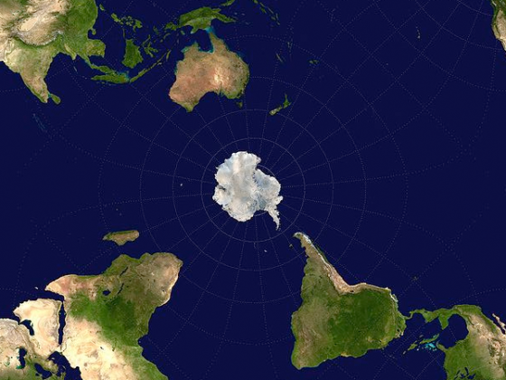
We’re used to the highly-skewed, Euro-centric Mercator Projection map of the world, so this alternative, hemisphere-bending map is sure to give you a blood rush to the brain. Redditor Fiery West submitted to the site a map of the world from an Antarctic point of view, and it’s blowing everyone’s minds.

Instead of the primary focus being on North America, Europe, and Asia, this map gives the spotlight to Australia, South America, and of course Antarctica itself right in the center. The southern tip of South America actually appears to be reaching out to Antarctica. Also standing out is how connected the world’s oceans are to each other — in this map, they nearly appear to be one.

Australia also holds a visibly strong position in relation to Antarctica, but in the map’s most notable demonstration of angle presentations, you can actually get a good feel for how big Africa really is. At 11.73 million mi², the world’s second largest continent is significantly bigger than both North America (9.54 million mi²) and South America (6.888 million mi²).

Traditional world maps often present a sort of “flat earth” outlook on the world, allowing the viewer to look at each continent in detail, all at the same time. (Except, of course, for poor New Zealand, who frequently seems to have fallen off the edge). Some maps show Earth from the top down with the North Pole standing as the focal point. But this is the first map we’ve seen of the inverse, and if any country appears closer to getting the boot this time, it’s Iceland.

Discover Matador