You’ve heard of the Vatican, Athens, and Iguazú. Heck, you’ve probably been there. These attractions draw huge numbers of tourists each year, thanks in part to the UNESCO statuses they’ve earned for their cultural significance, natural beauty, or both. What you may not know is that there are over 1,000 UNESCO World Heritage sites around the world — and some of them come with surprisingly thin crowds.
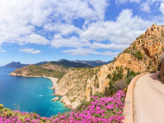
Photo: Balate Dorin/Shutterstock
13 of the Most Underrated UNESCO Sites You Need to Visit
The fact that certain UNESCO World Heritage sites have remained relatively crowd-free is not indicative of their significance or beauty. Factors like ease of access and guidebook hype can affect how popular a site becomes. But if you’re willing to travel a bit deeper, you can check out these 13 amazing and underrated UNESCO sites from Spain to Seychelles — and have the place nearly to yourself.
We hope you love the spaces and stays we recommend! Just so you know, Matador may collect a small commission from the links on this page if you decide to book a stay.
Africa | Asia | Americas | Europe | Oceania
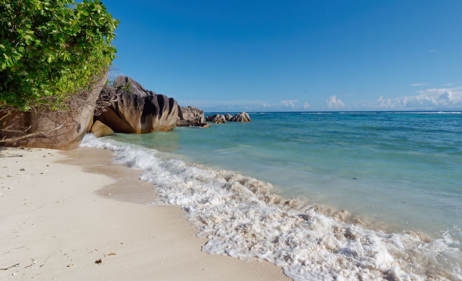
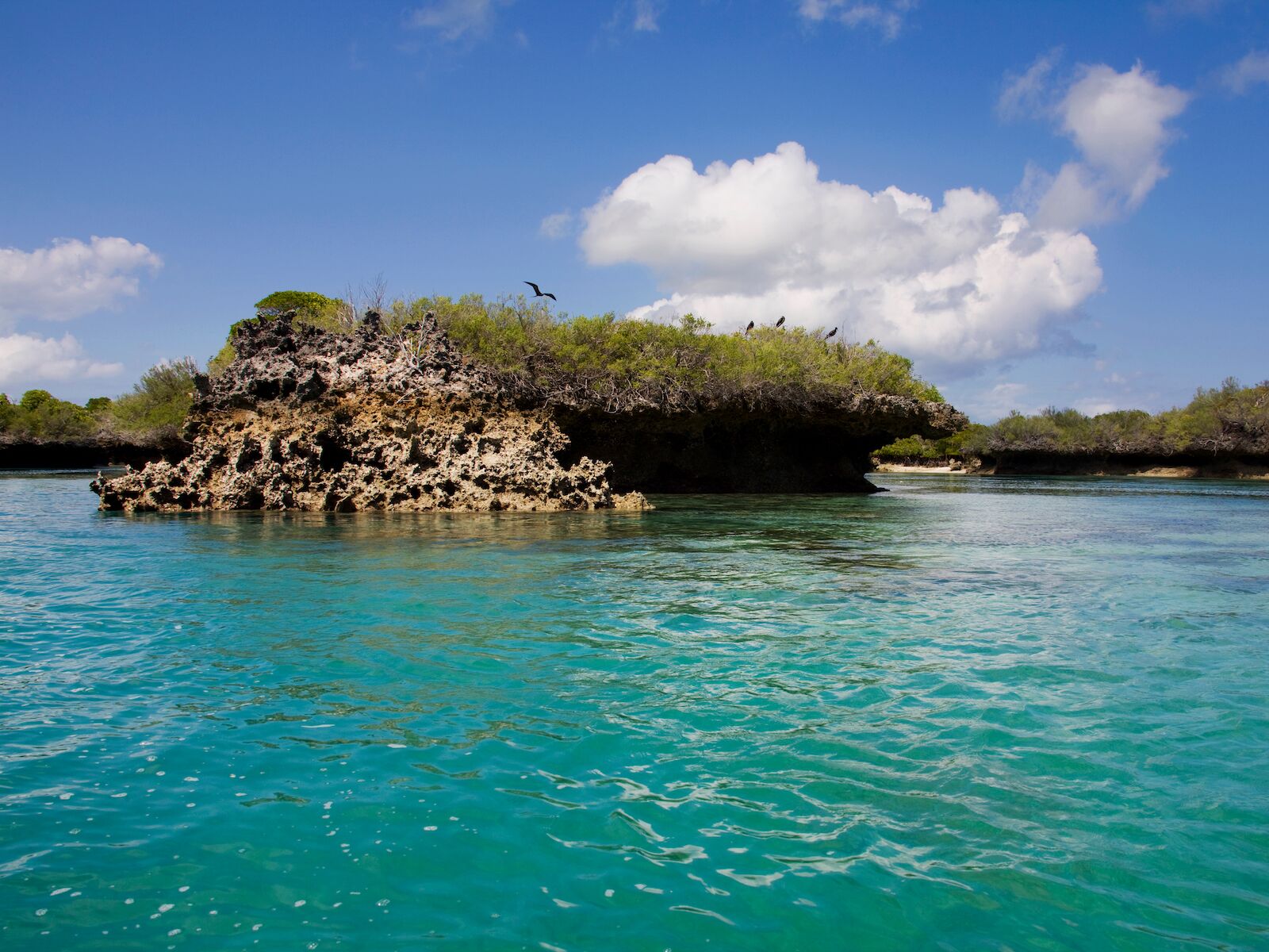
Aldabra Atoll, Seychelles

- Inscription date: 1982
- Why it’s underrated: Aldabra’s extreme isolation has historically kept humans from settling there, let alone popping over for a visit. Tourism remains limited and regulated through the Seychelles Islands Foundation (SIF). But you can visit, provided you get permission from the SIF, or book a trip through an approved company.
- When to go: April-May, October-November
- How to get there: Fly to Mahé (main island of Seychelles) via Europe or the Middle East, then book a live-aboard cruise for the epic 600-mile sail to Aldabra.
- What not to miss: Only select zones on the western and northern edges of the atoll are open to visitors. It’s possible to see giant tortoises in the wild in these zones — as well as a Grand Poche frigatebird colony — but there are also two giant tortoises at the atoll’s research station that visitors can approach more closely.
When it comes to African islands in the Indian Ocean, Madagascar gets a lot of attention for its natural beauty and diverse wildlife — DreamWorks even made a movie about it. But just north, roughly 600 miles southwest of the main Seychelles group in the archipelago’s Outer Islands, sits a group of four islands that make up the Aldabra Atoll, one of the largest coral atolls and least disturbed ecosystems on the planet.
Between coastal beaches, coral reefs, mangrove mudflats, scrub forests, and seagrass beds, Aldabra hosts a wide range of habitats that create a breeding ground for incredible biodiversity. But what’s most impressive is the fact that over 400 of the atoll’s species are endemic. Arguably, the most notable species is the Aldabra Giant Tortoise, whose 100,000-plus population is the largest giant tortoise population on Earth.
Because Aldabra is strictly managed by the SIF and has no tourist infrastructure — no hotels, docks, helipads, or visitor centers — you can’t stay on the atoll itself. Instead, most visitors embark on multiday live‑aboard cruises — especially those run by Silhouette Cruises’ Aldabra Expeditions — departing from Mahé or Assumption Island. These cruises bundle transport, lodging, meals, and guided excursions into a single, expertly managed package.
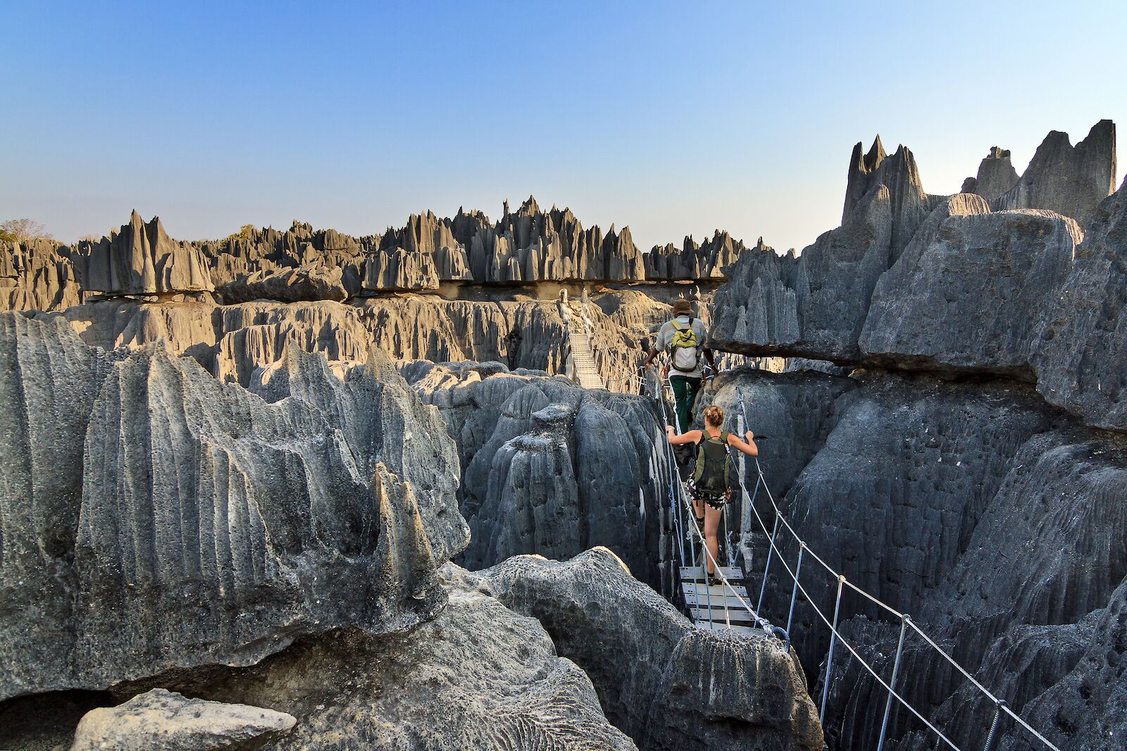
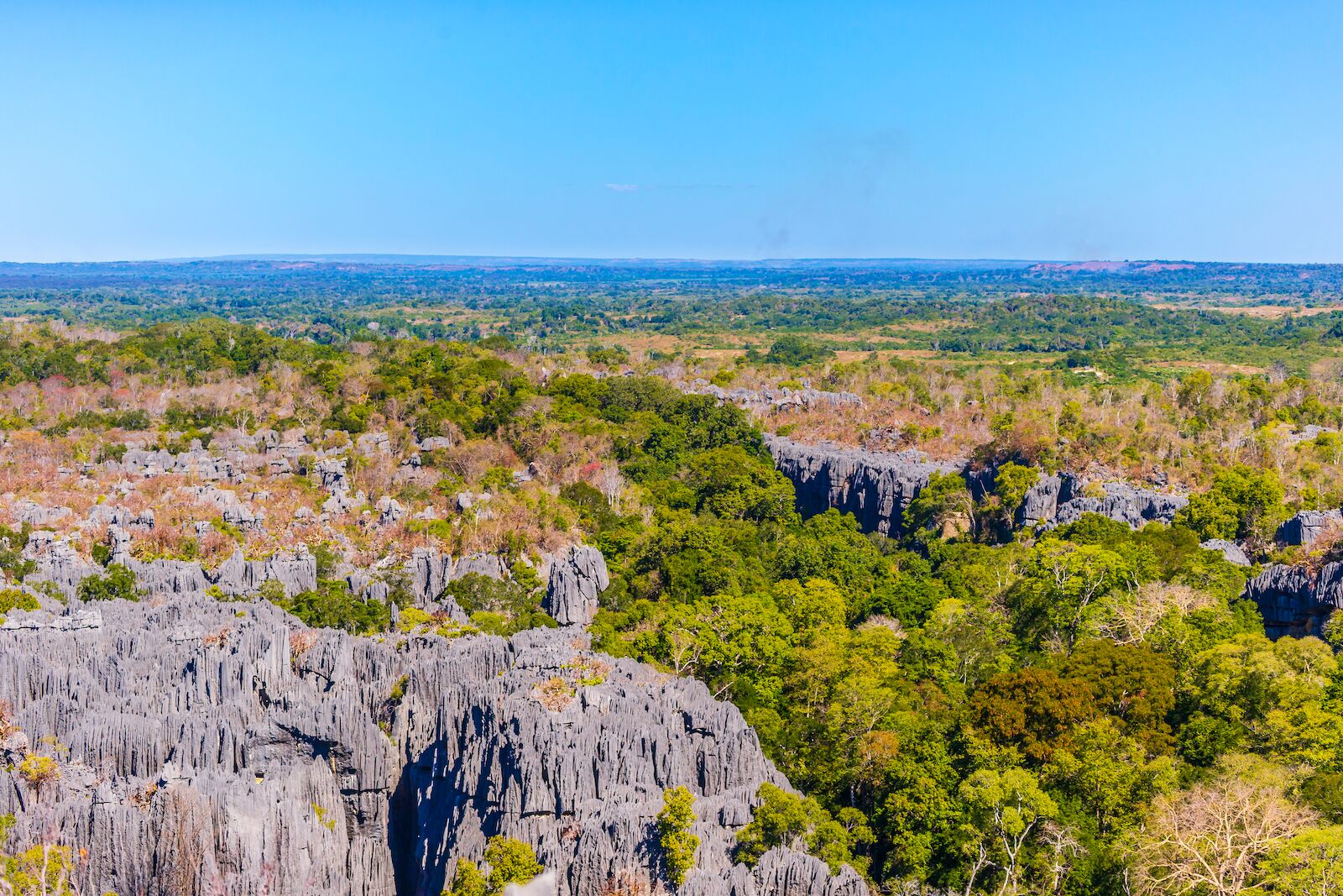
Tsingy de Bemaraha Strict Nature Reserve, Madagascar
- Date of Inscription: 1990
- Why it’s underrated: There’s a “forest” of limestone pinnacles — and it’s as wild as it sounds.
- When to go: April-October
- How to get there: Fly into Antananarivo, then catch an early taxi or van to Morondava (a full-day overland adventure), before hiring a 4×4 (or getting a driver) for the rough drive and river crossing to Bekopaka.
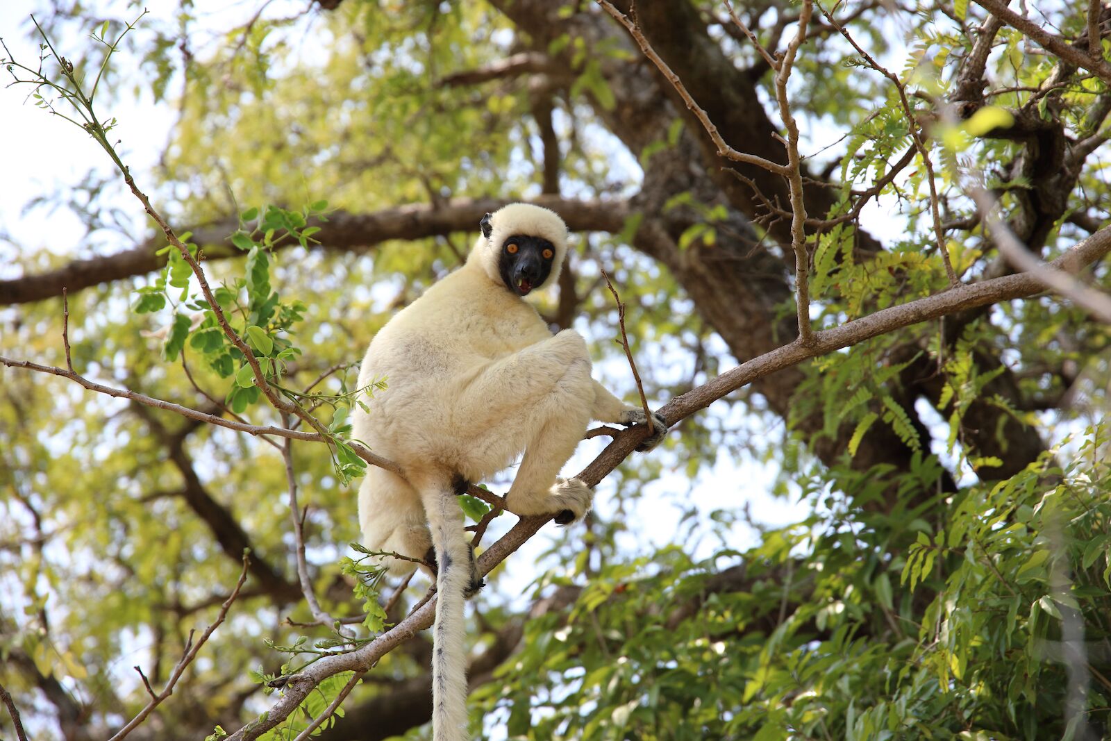
- What not to miss: Tsingy de Bemaraha Strict Nature Reserve is split between Big Tsingy and Little Tsingy. If you only have time for one, make it Big Tsingy. But be warned, walking tours of Big Tsingy are challenging — think harnesses, carabiners, and dizzying heights. One of the biggest payoffs? All the lemurs you’ll pass along the way.
Limestone is type of sedimentary rock that’s incredibly common and relatively unremarkable. But the formations they’ve made in Tsingy de Bemaraha is anything but ordinary — clusters of jagged, pointy spires that can reach heights of over 300 feet create a landscape akin to horizontal cliffs at this nature reserve in west-central Madagascar.
But that’s just some of what the landscape has in store. Within Tsingy, there’s also deciduous forests, savannas, mangrove swamps, lakes, rolling hills, and the Manambolo River that cuts through it. Several species that live in the park are only found locally — so many, in fact, that Tsingy is considered a “center for endemisim” — but lemurs and rare bird species are the highlights for wildlife lovers.
There are no hotels inside the protected area, so visitors typically base themselves in the small village of Bekopaka, near the park entrance. Olympe du Bemaraha is a good, mid-range choice, offering private bungalows, an outdoor pool, and an on-site restaurant serving Malagasy dishes. The helpful staff can easily arrange guided hikes into the Tsingy, as well as 4×4 transfers right from reception. For travelers seeking something more upscale, Le Soleil des Tsingy provides spacious eco-bungalows with panoramic river views, an infinity pool, and guided nature walks through its private reserve — ideal if you crave extra comfort after a day spent navigating the limestone pinnacles
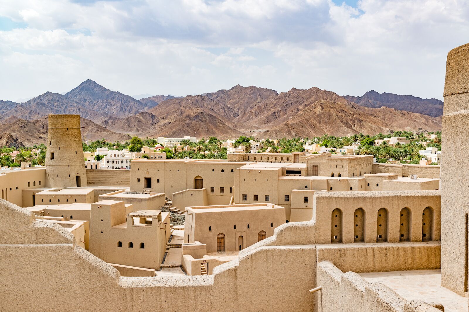
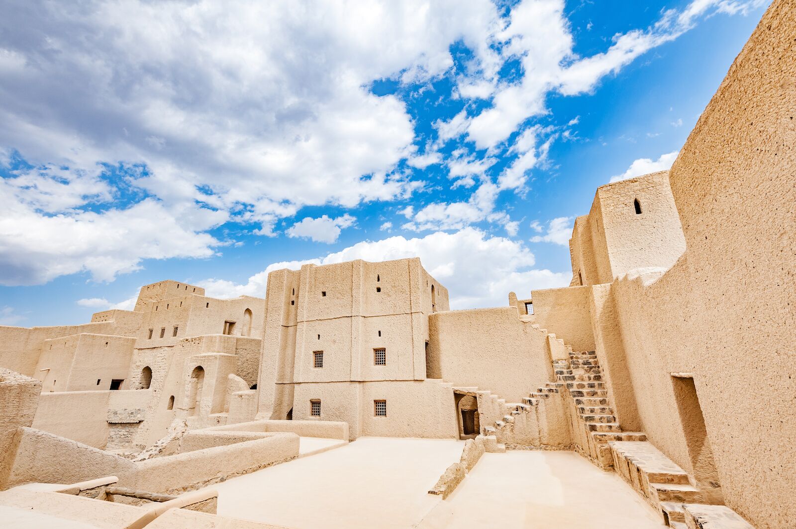
Bahla Fort, Oman
- Date of Inscription: 1987
- Why it’s underrated: Though the Nizwa Fort is one of Oman’s most popular tourist attractions, the Bahla Fort is just 30 minutes away and the only fort in Oman with a UNESCO designation.
- When to go: October-March
- How to get there: Fly into Muscat (one to two stops from the US), rent a car, and drive about two hours southwest on the highway to the mud‑brick walls of Bahla Fort. If you’re not comfortable renting a car, local bus or taxi options are available for the final stretch.
- What not to miss: Surrounding the fort are mud-brick houses arranged around afalaj irrigation channels, an ancient infrastructural system that inspired its very own UNESCO designation.
Like much of Omani history, the accomplishments of the Banu Nebhan tribe that ruled central Oman between the 12th and 15th centuries, due in large part to a prosperous frankincense trade, remains unknown to many. Bahla, the historical capital of the Banu Nebhan, and its namesake fort are testimonies to the tribe’s prosperity.
To start, the fort is large — approximately eight square miles. And its engineering is impressive, from defensive structures such as castellated parapets to the afalaj watering system that ensured both farming and daily life were sustainable. Just outside of the fort’s boundaries, the Friday Mosque and remains of a semi-enclosed souq also testify to how significant, and successful, Bahla was for the Banu Nebhan people.
Although Bahla is small, it’s still a handy base for exploring the fort — many visitors stay in simple, apartment-style lodgings or farm stays near town. But travelers looking for more comfort often opt for Nizwa instead, just a half-hour drive away, where you’ll find a warmer mix of comfort and culture. At IntercityHotel Nizwa, you can enjoy modern amenities — including a rooftop infinity pool with mountain vistas, a spa, gym, and on-site restaurants — just minutes from the Grand Mall, Nizwa Fort, and the souq.
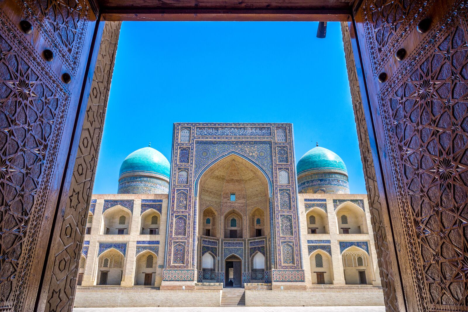
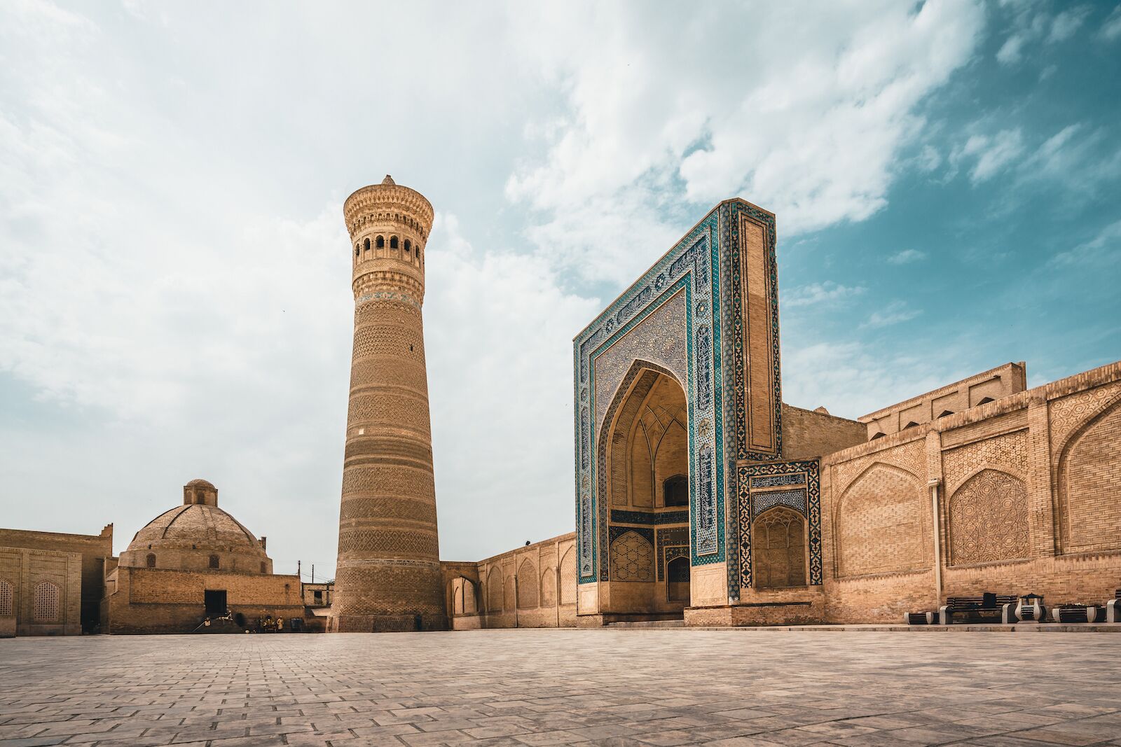
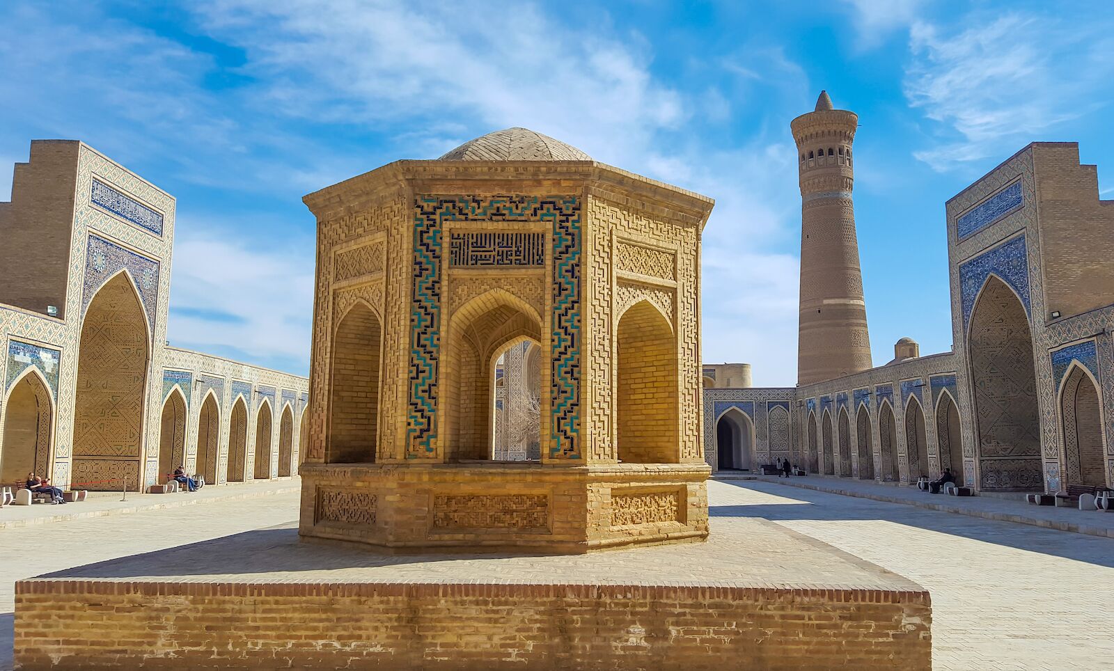
Historic Centre of Bukhara, Uzbekistan
- Inscription date: 1993
- Why it’s underrated: The tiled architecture of Bukhara’s mosques, madrasas, and minarets are as elaborate and intricate as anything you’d recognize from Morocco or Iran.
- When to go: April-June, September-November
- How to get there: Fly into Tashkent (usually via Istanbul, Doha, or Frankfurt), then hop a high-speed train (about four hours) or a short flight (around one hour) to Bukhara.
- What not to miss: About 20 minutes west of Bukhara, the Chor-Bakr memorial complex is another striking Uzbek historical site that’s been awaiting UNESCO status since 2008.
Maybe travelers miss this ancient hub of Islamic culture because of Uzbekistan’s proximity to Middle Eastern nations shown in the news for ongoing conflicts — or maybe they just can’t find it on a map. But you’ve definitely heard of the city’s most famous visitor: Marco Polo. The Italian merchant and his family set up shop here for three years due to its location along the Silk Road, which made the city an important cultural and economic hub for centuries.
While the beautiful brick Poi-Kalyan minaret, the Magoki Attori mosque, and the famous Ismail Samani tomb are highlights of 10th- and 11th-century Muslim architecture, it’s the entire urban center as a whole, one of the most complete examples of a well-planned and -preserved ancient Central Asian town, that stands out.
You’ll find no shortage of places to stay within Bukhara’s old town walls, where charming riads and modern hotels cluster around the Poi-Kalyan complex. Hotel Omar Khayyam stands out for its rooftop terrace with sweeping views of the minaret, authentic Uzbek décor, and courteous staff who can help arrange local guides. If you prefer something more intimate, Minzifa Boutique Hotel has cozy suites in a beautifully restored madrasa.
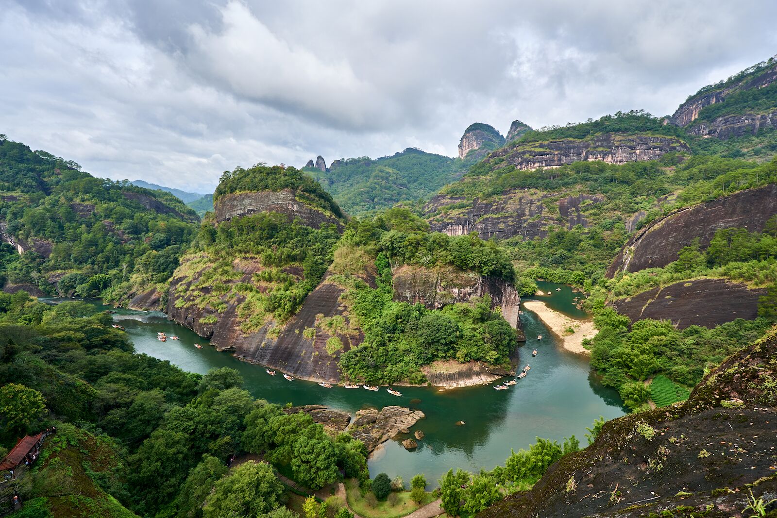
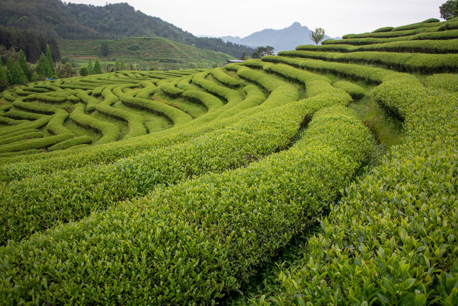
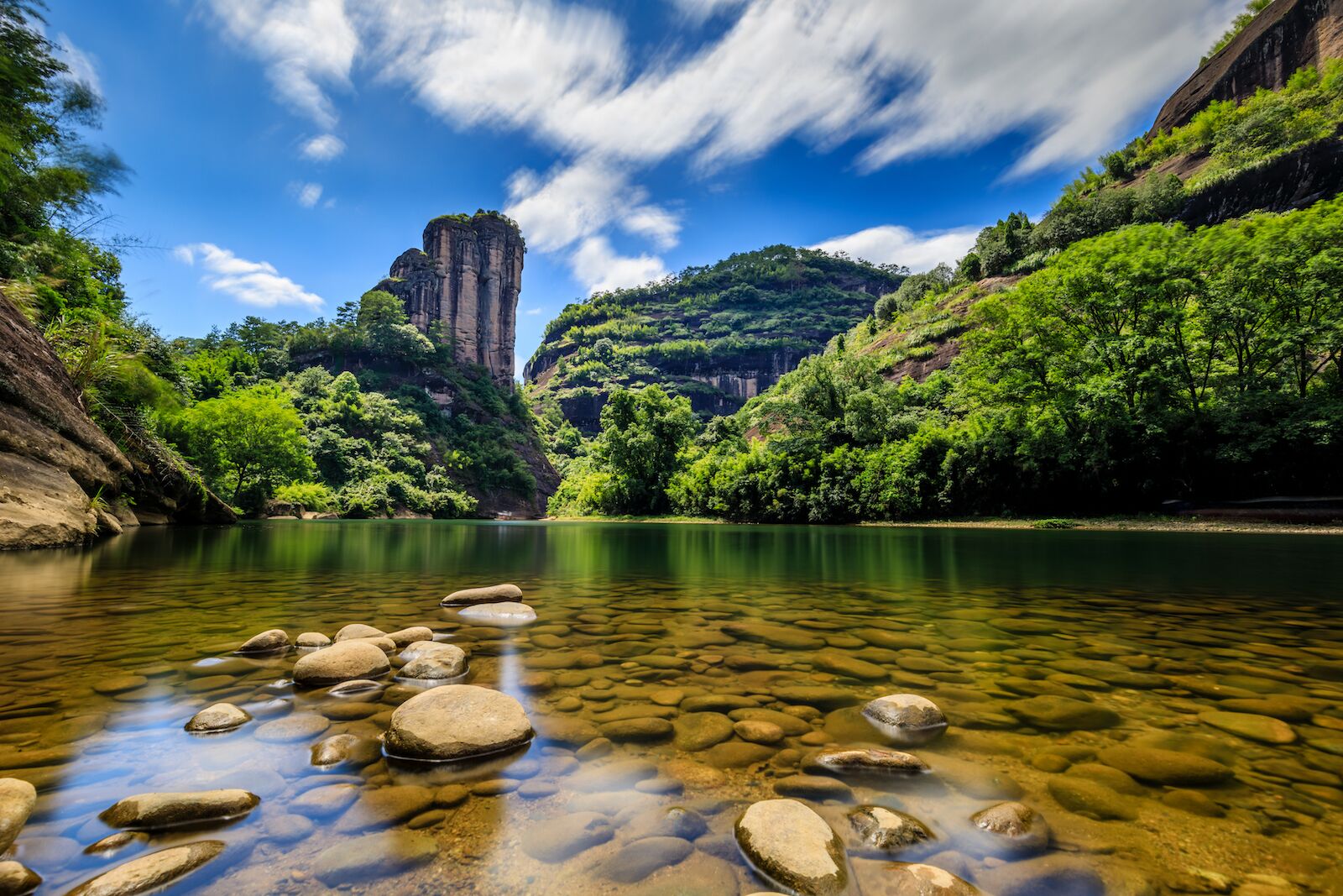
Wuyishan, Fujian, China
- Inscription date: 1999
- Why it’s underrated: Mount Wuyi, at the heart of the Wuyishan range, plays host to a sizeable and mostly intact rainforest that exemplifies the ecological variety found within the Chinese Subtropical Forest and South Chinese Rainforest better than anywhere else in the country.
- When to go: September-November
- How to get there: Fly into Fuzhou or Xiamen (via a major Asian hub), then hop on a high-speed train — around three to three and a half hours — to Wuyishan, and take a short taxi or shuttle ride to the Mountain Wuyi scenic area.
- What not to miss: Wuyishan is the birthplace of Oolong tea, and you can see six mother trees of one of the most famous types of Oolong, Da Hong Pao, in the Da Hong Pao scenic area. After, stop by a local Wuyi teahouse to get some as a souvenir.
Mount Wuyi gives visitors a look at both the biodiversity and history of China in one package. Temples and monasteries where neo-Confucianism blossomed line the epic gorges of the Nine Bend River, and Han dynasty rulers established a prominent administrative capital in the first century BCE where an archeological site now stands.
Located in the southeast province of Fujian, the area surrounding Wuyishan serves as a refuge for ancient wildlife — notably reptiles, amphibians, insects, and plants — many of which are only found in their native China. While many travelers only see the Great Wall, the cultural and ecological significance of the Wuyishan make it worth the visit.
You’ll find a great range of lodgings in Wuyishan town, right next to the mountain — perfect for exploring the scenic area and nearby tea plantations. C&D Resort, Wuyi Mountain sits riverside within the Wuyi Mountain Scenic Area, facing The Great King Peak. Guests praise its indoor pool, fitness center, and the fact it’s just a five-minute walk from the Da Hong Pao scenic zone. For something cozier and more local, Ancient Street No. 5 Youth Chic Hotel offers clean, modern rooms in a riverside or garden setting, along with friendly staff and proximity to bamboo-rafting launch points.
Huascarán National Park, Peru
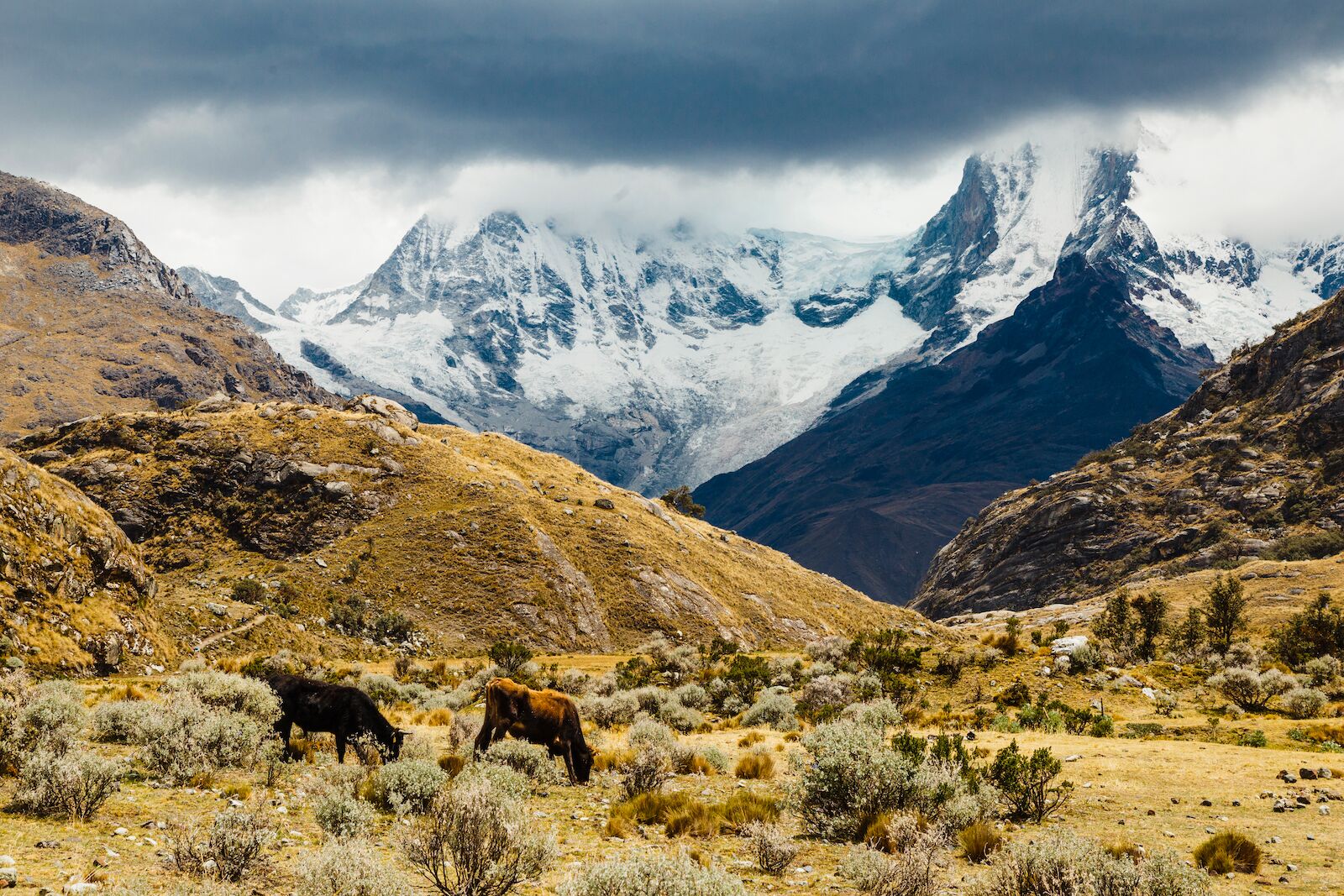
Photo: Gabriela de Echave/Shutterstock
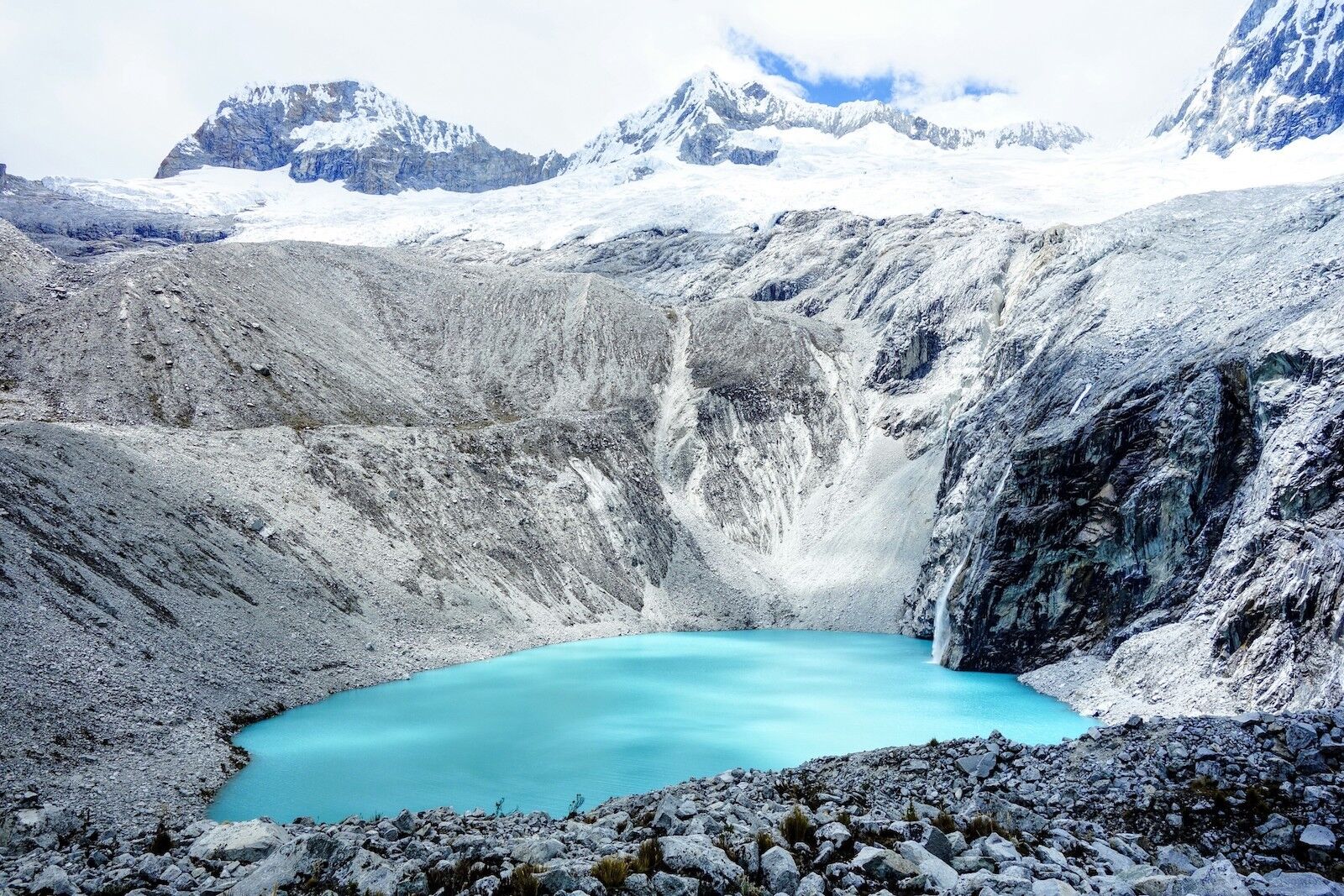
Photo: Ricard MC/Shutterstock
Photo: brunocabralbc/Shutterstock
- Inscription date: 1985
- Why it’s underrated: At over 22,000 feet, the national park’s namesake mountain, Huascarán, reaches the tallest point in Peru and the fourth-tallest point in South America.
- When to go: April-September
- How to get there: Fly into Lima, then either catch a quick one‑hour flight or ride an overnight bus (about eight to ten hours) up to Huaraz — the lively mountain town that’s your gateway into the park.
- What not to miss: Between peaks, the park is dotted with brilliantly blue lakes and lagoons, notably Lake Llanganuco and Laguna 69.
Once you’ve done your obligatory visit to Machu Picchu, head northwest to the striking landscape of Peru’s Cordillera Blanca, the world’s highest tropical mountain range. Here, you’ll find over 100 glacial lakes, pockets of varying vegetation, and tropical glaciers set among snow-covered mountains — specifically, the national park’s centerpiece is a cluster of 27 sky-high peaks, including Huascarán itself. The spectacled bear and Andean condor call this breathtaking UNESCO site home. With natural beauty like this, you’ll wish you could, too.
Most visitors heading into Huascarán stay in the mountain town of Huaraz, about an hour’s drive from the park entrance. Hotel Andino Club offers spacious rooms, a heated indoor pool, sauna and spa, hearty breakfasts, plus guided-trek packages — ideal for acclimatizing before hitting the trails. It’s within easy walking distance of gear shops, cafés, and tour operators — making the hotel an excellent launchpad for day trips to Lake Llanganuco, Laguna 69, or higher-altitude treks in the Cordillera Blanca.
Kluane/Wrangell-St Elias/Glacier Bay/Tatshenshini-Alsek National Parks, US and Canada
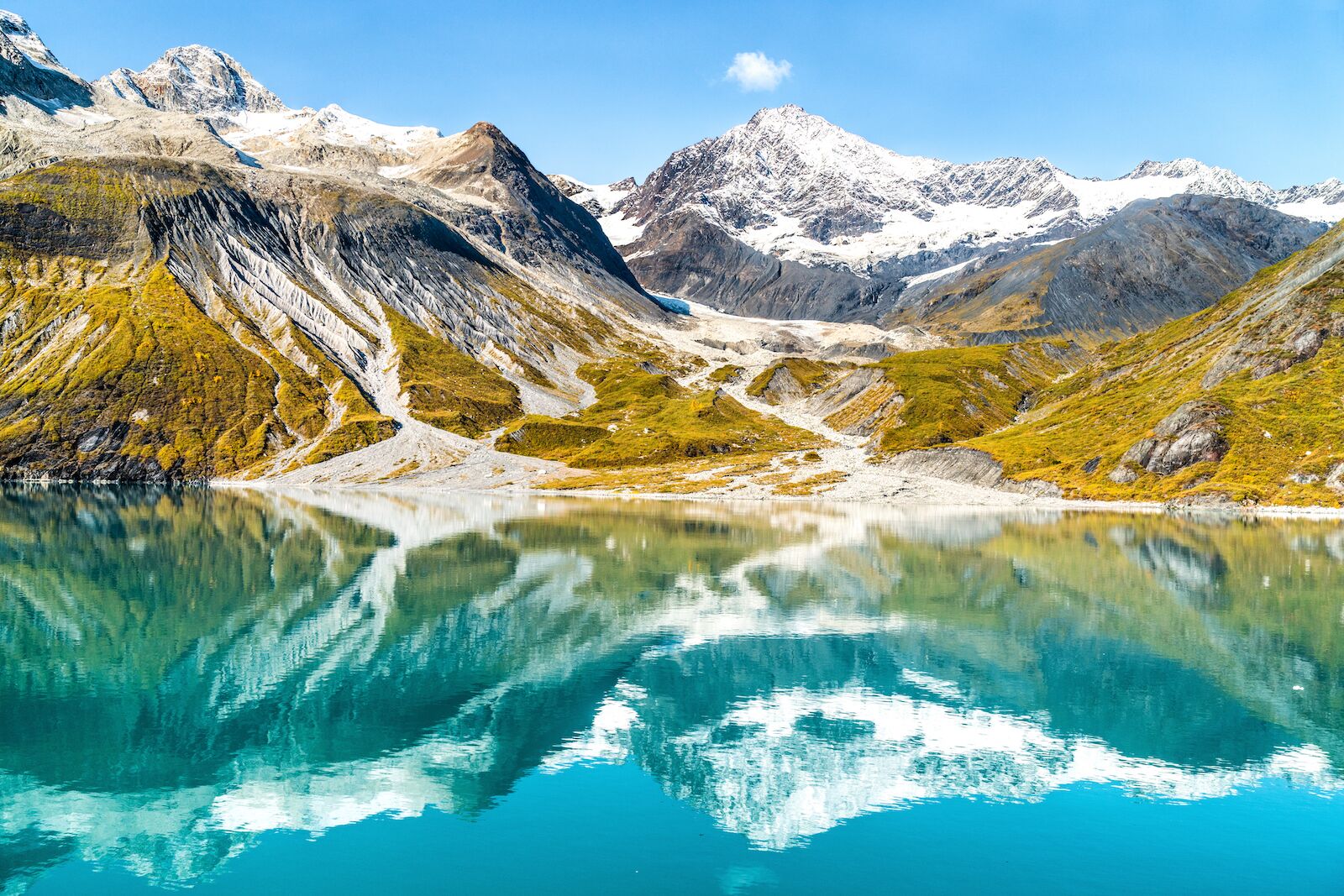
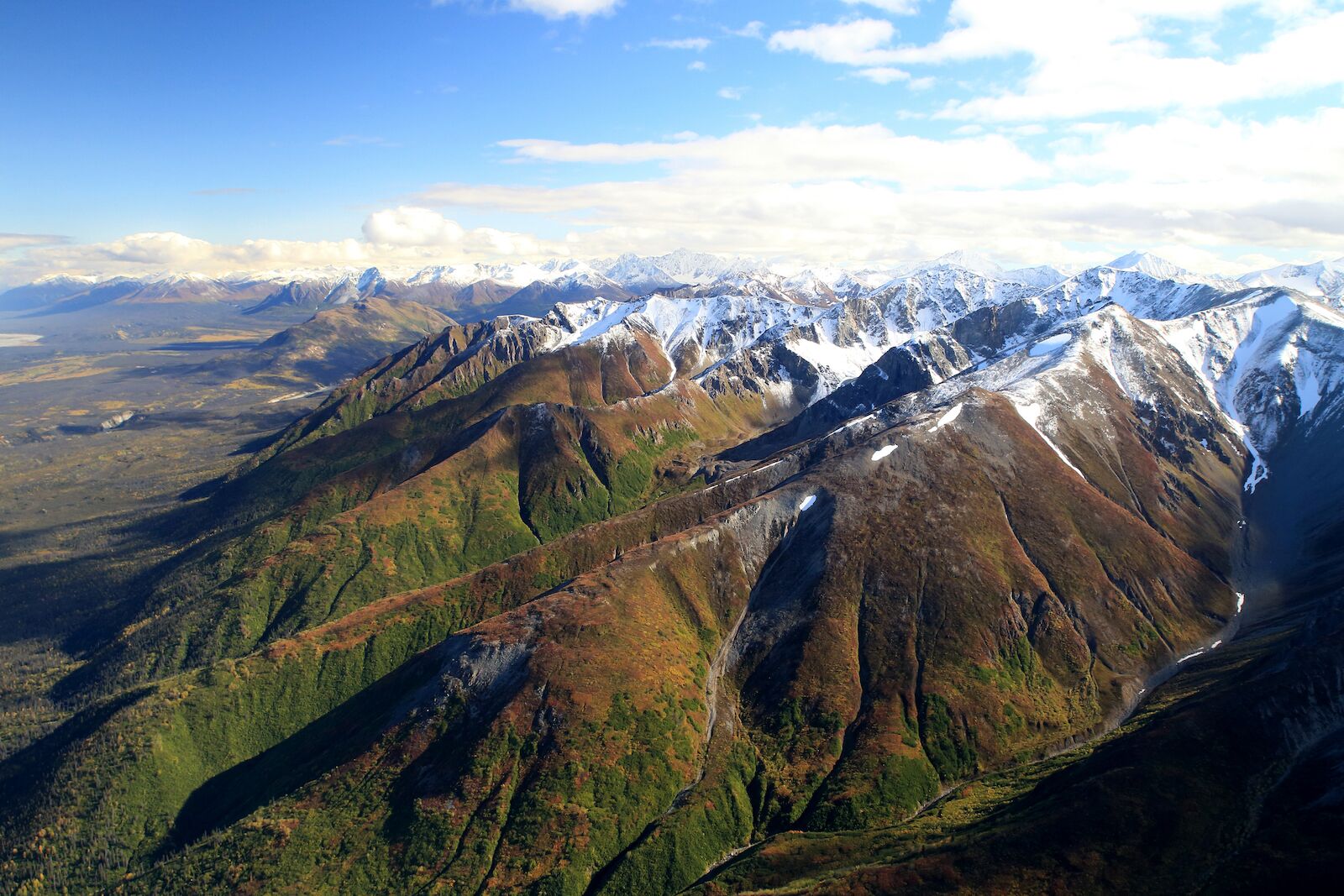
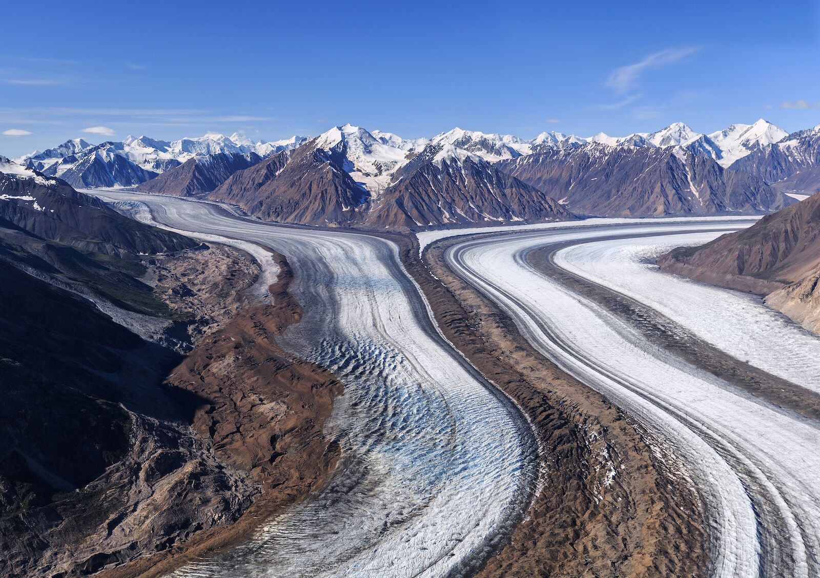
- Inscription date: 1979 (extended 1992 and 1994)
- Why it’s underrated: You can knock off four national parks at once.
- When to go: June-August
- How to get there: Fly into Anchorage, then drive or catch a short regional flight east to access Wrangell–St. Elias; from there, rent a 4WD to explore gravel roads into the backcountry. To hit Glacier Bay, cruise or ferry out of Juneau. For Kluane and Tatshenshini-Alsek, head north into Yukon — either by self-driving from Haines Junction or tagging on a guided river-raft trip through remote valleys.
- What not to miss: Mount Logan, the tallest peak in Canada and the second-tallest peak in North America, sits in Kluane National Park.
If you want to see the world’s largest non-polar icefield backed by towering, snow-capped mountains, you won’t be heading to Yosemite, Yellowstone, or Banff. Instead, trek to this underrated UNESCO site comprised of four impressive national parks along the US-Canada border between the Yukon Territory, British Columbia, and Alaska. It’s one of the last places on Earth where natural evolutionary and environmental changes still control ecological processes. Populations of animals that are endangered elsewhere, like grizzly bears and Dall sheep, self-regulate and thrive in this untainted environment.
Anchorage makes the easiest springboard into this vast wilderness, offering the broadest range of hotels, rentals, and guiding services before you head deeper into Alaska and the Yukon. For places with more character, check out Matador‘s roundup of Airbnbs in Anchorage that make a perfect jumping-off point for exploring Alaska’s wildest corners.
Mesa Verde National Park, Colorado
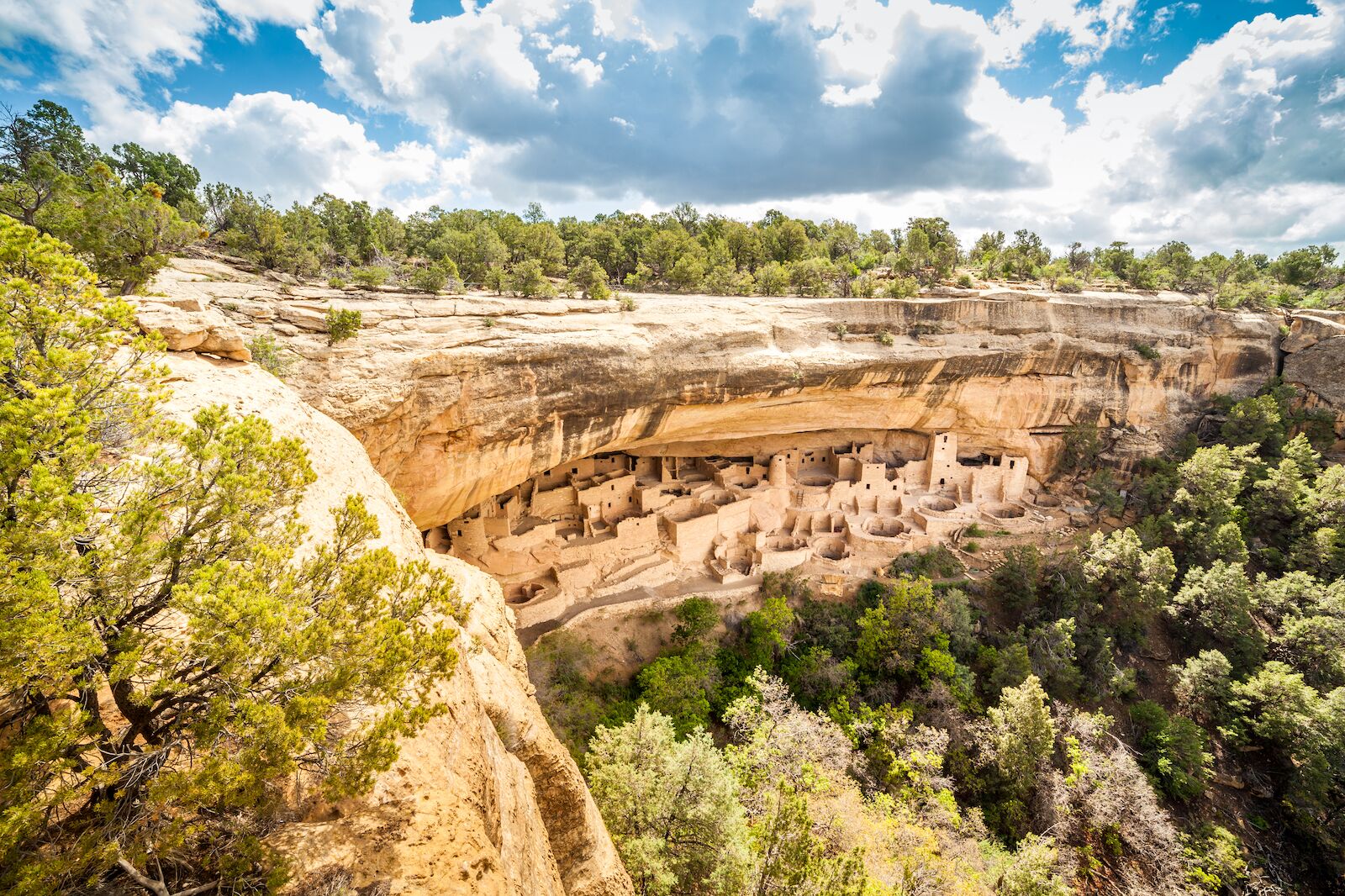
Photo: Sopotnicki/Shutterstock
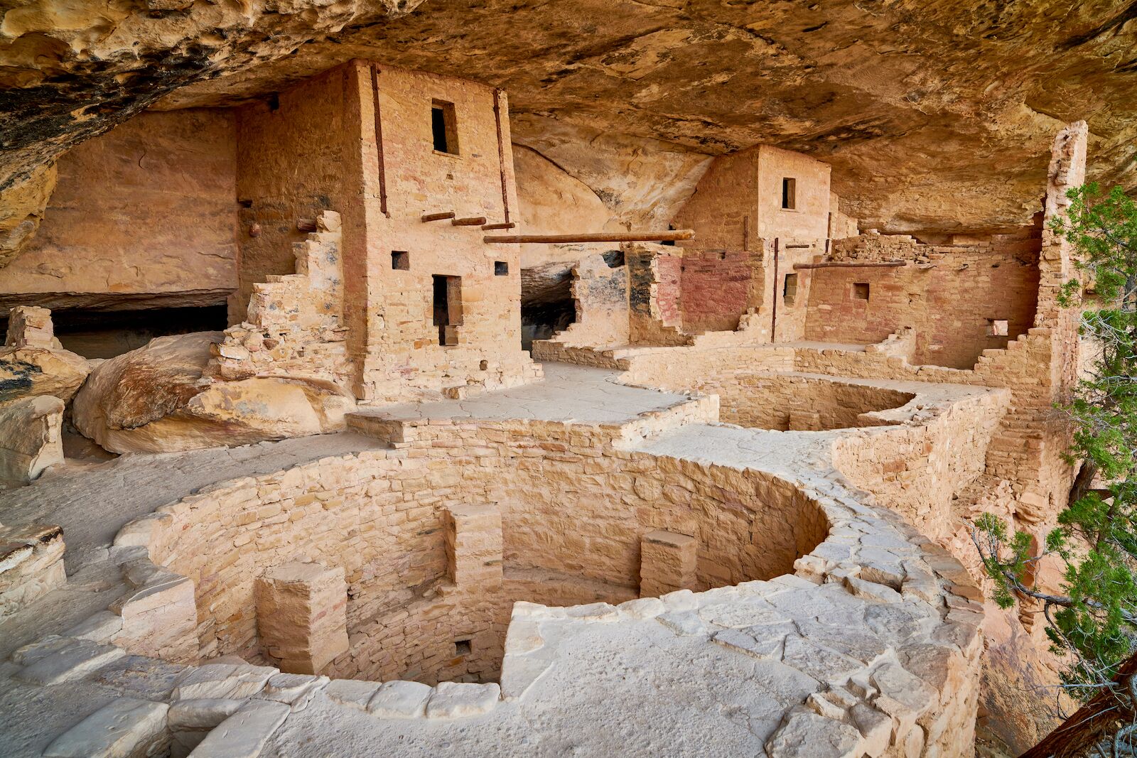
Photo: Patrick Jennings/Shutterstock
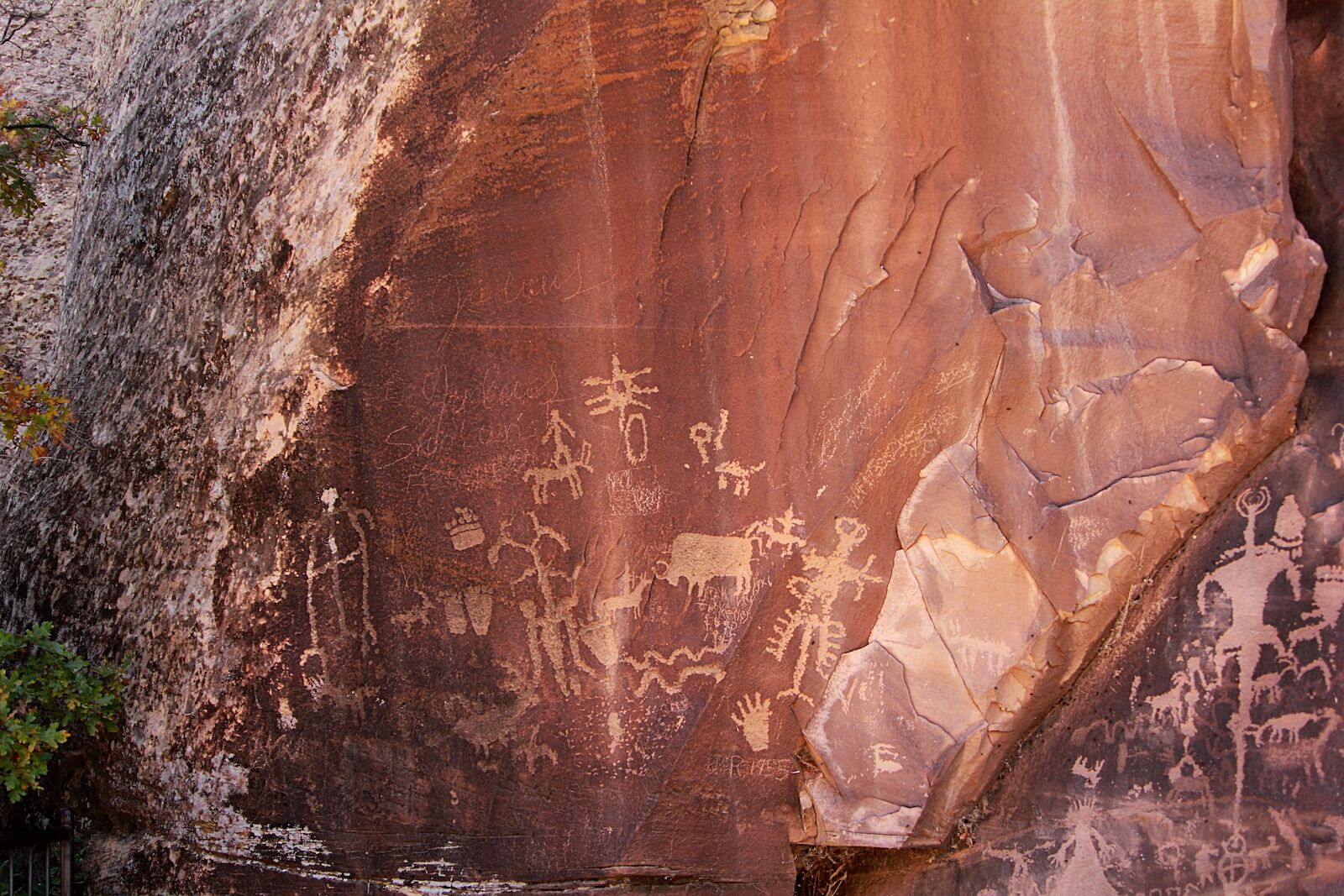
Photo: Faina Gurevich/Shutterstock
- Date of Inscription: 1978
- Why it’s underrated: Several US national parks are inscribed as UNESCO World Heritage sites, but Mesa Verde is the only one listed solely for its cultural significance.
- When to go: May-June, September-October
- How to get there: From Durango, it’s an easy 45-minute drive west on US-160 straight to Mesa Verde’s entrance — perfect for a quick day trip into the cliff dwellings and canyon trails.
- What not to miss: The 2.4-mile Petroglyph Point loop trail is the only trail in Mesa Verde National Park that showcases prehistoric rock carvings, alongside excellent views of the Spruce and Navajo Canyons.
Mesa Verde National Park is set in a scenic plateau in southwest Colorado, but it’s not the vistas that attract visitors — it’s the network of Pueblo Indian dwellings constructed between the sixth and 12th centuries around which the park’s boundaries were drawn.
In total, there are around 4,400 archaeological dwellings within the park. The most eye-catching were erected inside natural alcoves within cliff faces, though ancient villages were also built atop the mesa. And they’re no small settlements. The largest of Mesa Verde’s cliff dwellings — which total around 600 — contain as many as 200 different rooms. Among the most famous sites are the Cliff Palace, Balcony House, and Square Tower House. In addition to housing, these sites served multiple purposes, from storage to shrines to farming terraces.
At more than 8,500 feet, Mesa Verde also has value as an outdoors destination, with roughly 30 miles of trails within the park. The longest loop, the Prater Ridge Trail, spans nearly eight miles between the North and South Loops, which together showcase the scenery of the Prater and Morefield Canyons, Montezuma Valley, and the San Juan Mountains.
Durango works well as a base, offering everything from historic inns to modern hotels just 45 minutes from the park gates. If you’d rather have your own space, Matador‘s selection of Airbnbs near Mesa Verde highlights rentals where you can unwind after a day on the trails.
Historic Center of Morelia, Mexico
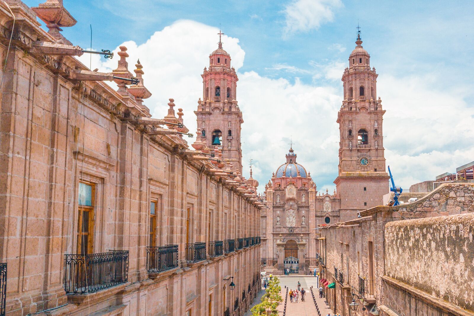
Photo: Rubi Rodriguez Martinez/Shutterstock
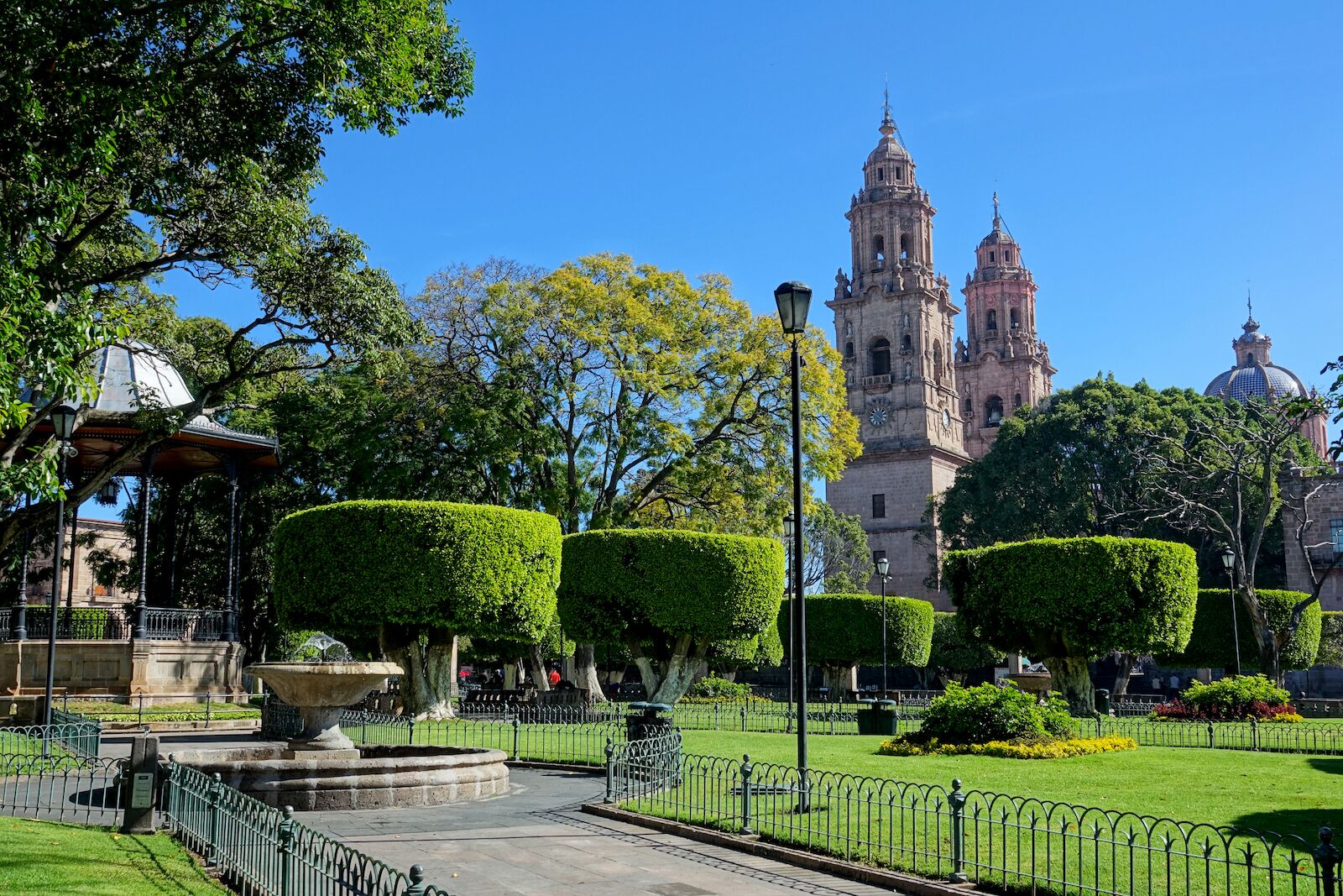
Photo: Francky38/Shutterstock
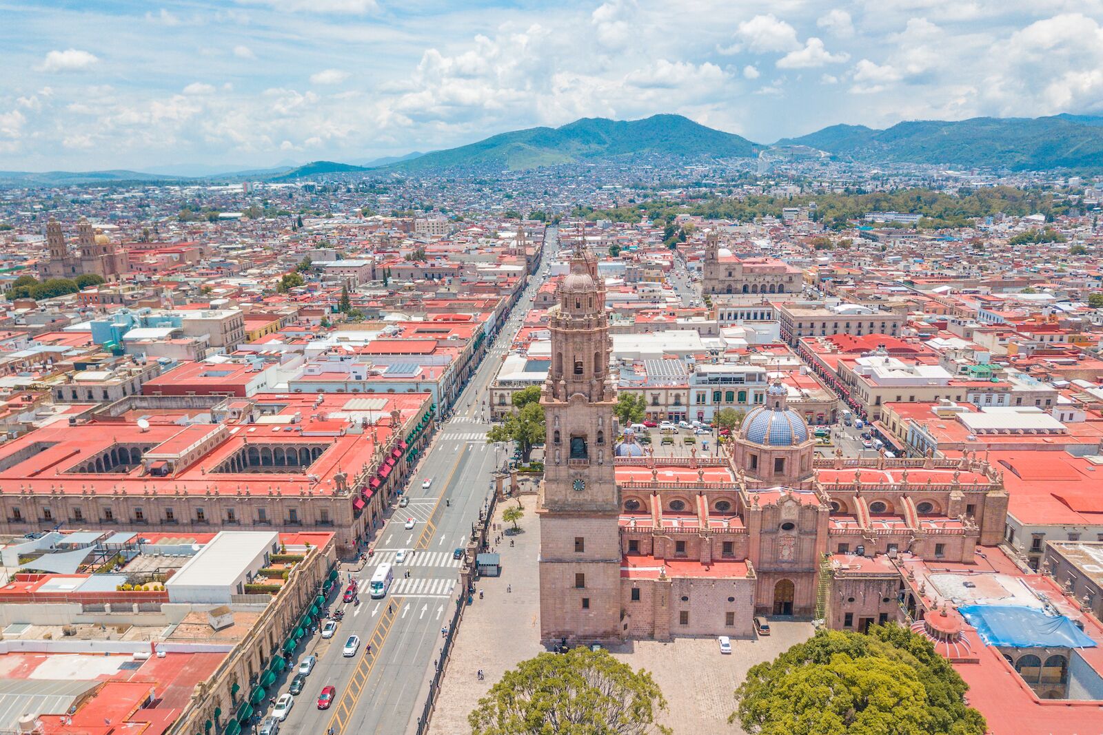
Photo: Rubi Rodriguez Martinez/Shutterstock
- Inscription date: 1991
- Why it’s underrated: The capital of Mexico’s Michoacán state, Morelia has a food culture to rival Oaxaca’s — so much so that Michoacán’s traditional eats earned their own UNESCO designation on the list of Intangible Cultural Heritage of Humanity.
- When to go: January-April
- How to get there: Fly into Morelia International Airport — there are direct flights from cities like Chicago, Houston, Dallas, Los Angeles, Oakland, Fresno, San Jose, and Tijuana — then it’s a quick twenty-minute ride by taxi, shuttle, or rental car to the heart of the pink‑stone historic center.
- What not to miss: Of the many mouthwatering foods you’ll find in Morelia, the city is most famous for producing sweets. In the historic center, check out the Museo de Dulce (Candy Museum) and Mercado de Dulces (Candy Market) to see — and taste — for yourself.
At the foot of the Sierra Madre Occidental range sits Morelia, a 16th-century city center that showcases a combination of Spanish Renaissance and Mesoamerican experiences. It was also one of the major centers where forces clashed during the nation’s battle for independence in the 19th century. There are over 200 historical monuments and buildings in Morelia’s historic core — including a whopping 21 churches — all constructed from the region’s characteristic pink stone. This architectural mastery makes it an underrated UNESCO site that’s a must-see for travelers visiting Mexico.
Set among Morelia’s iconic pink-stone buildings, Hotel Alameda Centro Histórico is popular for its sunny courtyard, comfortable rooms, and rooftop terrace overlooking Plaza de Armas and the grand cathedral. For a boutique option, Hotel Casa del Anticuario offers colonial charm and rustic décor in a cozy setting, just steps from Morelia’s historic center and the main plaza.
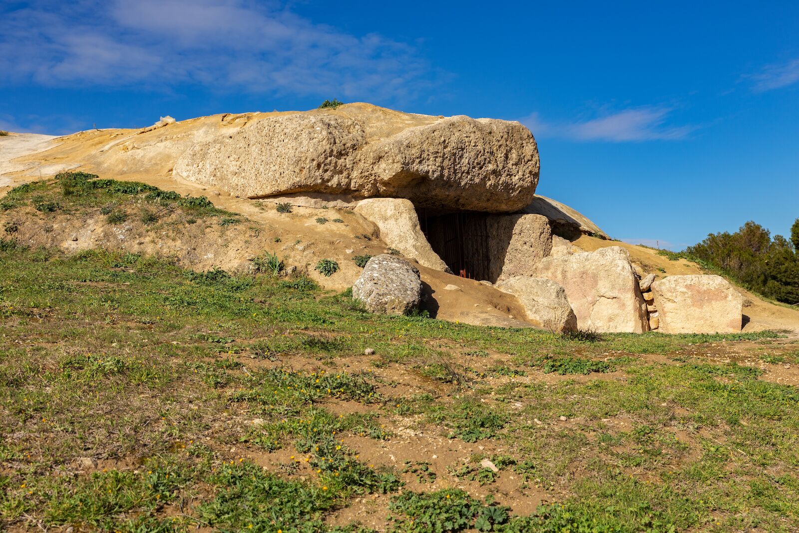
Antequera Dolmens Site, Spain
- Inscription date: 2016
- Why it’s underrated: Because of their recent inscription, the Antequera Dolmens in southern Andalusia are still largely unknown as a UNESCO World Heritage site to the many visitors who flock to the Alhambra of Granada or the Alcazar of Seville.
- When to go: April-May, September-October
- How to get there: Fly into Málaga (usually via Madrid or Barcelona), then it’s an easy 45-minute train or bus north to Antequera, where the dolmens are just a short walk or quick taxi ride away.
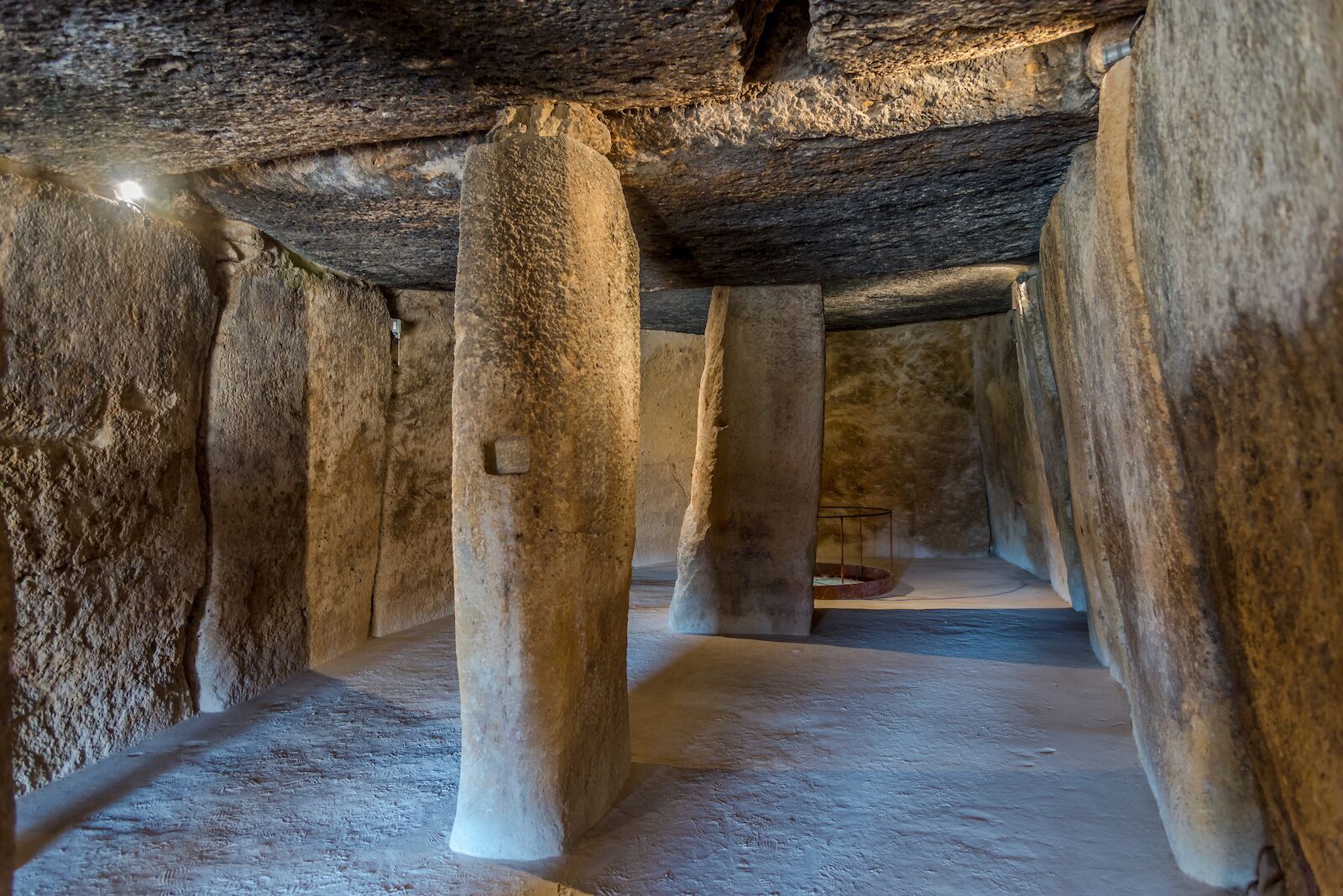
- What not to miss: The Menga Dolmen is one of the largest and heaviest megaliths in Europe. Calculated to weigh roughly 200 tons, it’s approximately seven times heavier than the largest megalith at Stonehenge, which is estimated to weigh about 30 tons.
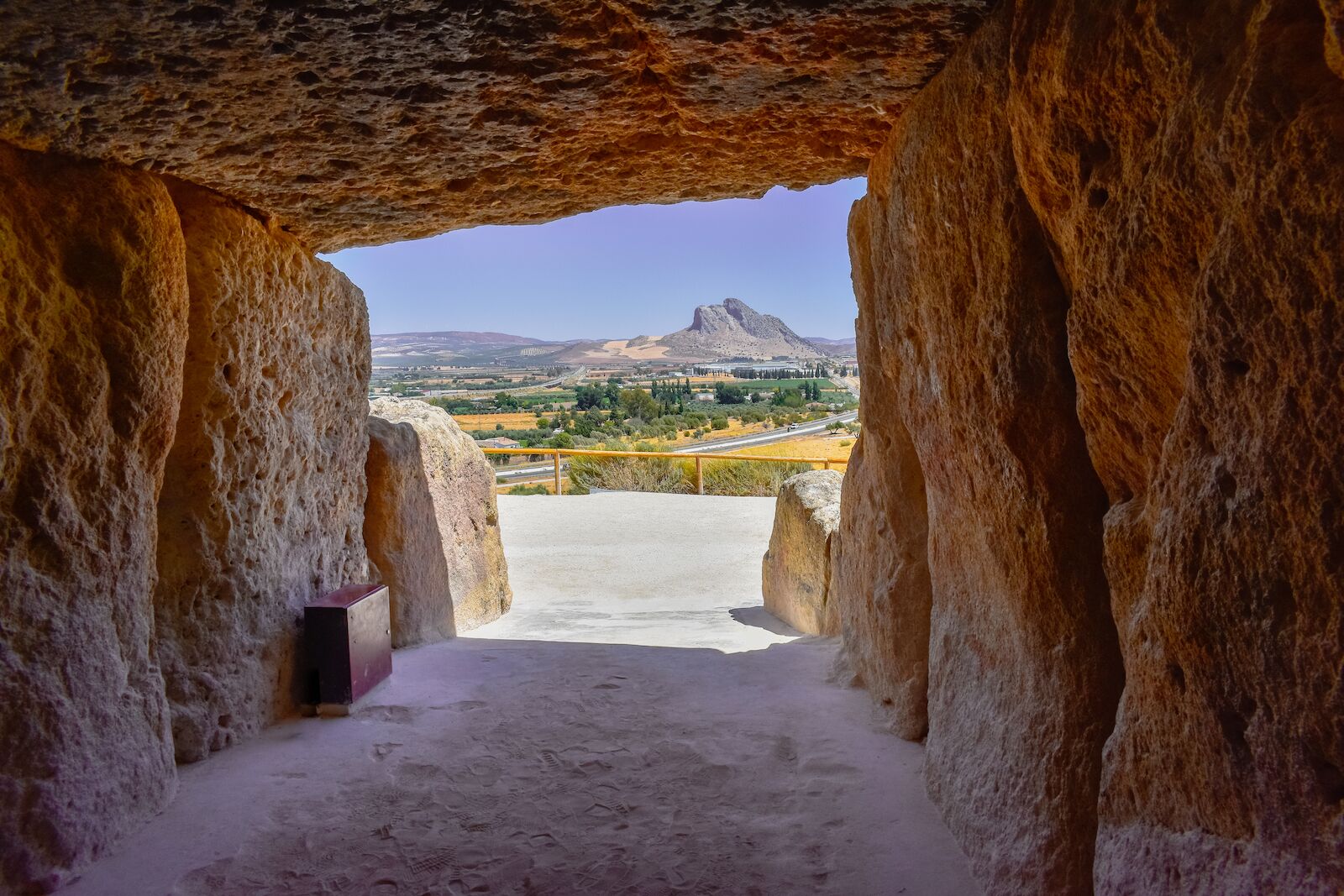
Built during the Neolithic and Bronze Ages, the Antequera Dolmens are a set of three megalithic tombs — the Menga and Viera Dolmens and the Tholos of El Romeral — that collectively represent one of the most remarkable examples of European Megalithism and prehistory. They’re hidden beneath the southern Andalusian landscape roughly 45 minutes north of Málaga, Spain, but there are two natural landmarks within the UNESCO site that let you know you’re close: La Peña de los Enamorados and El Torcal. In fact, the Menga Dolmen is the only dolmen on the European continent that points toward an anthropomorphic mountain — in this case, La Peña de los Enamorados, or the “the Rock of Lovers.”
Influenced by two ancient Iberian architectural traditions, the dolmens were built to host rituals and funeral practices. Their existence helps identify a time in history when Western Europeans began constructing large ceremonial monuments. The sheer size and number of stones used to create this archaeological marvel alone make it worthy of a UNESCO inscription — it makes Stonehenge look like toy in comparison.
If you plan to overnight in Antequera to see the dolmens at an unhurried pace, there are several top-rated hotels within walking distance of the archaeological complex. Parador de Antequera is a modern property with views of the surrounding countryside and a seasonal outdoor pool — an good base for exploring both the dolmens and the historic center. For something closer to the old town, check out Hotel Infante Antequera, for contemporary rooms in a convenient location near tapas bars and the Alcazaba fortress.
Gulf of Porto, Corsica, France
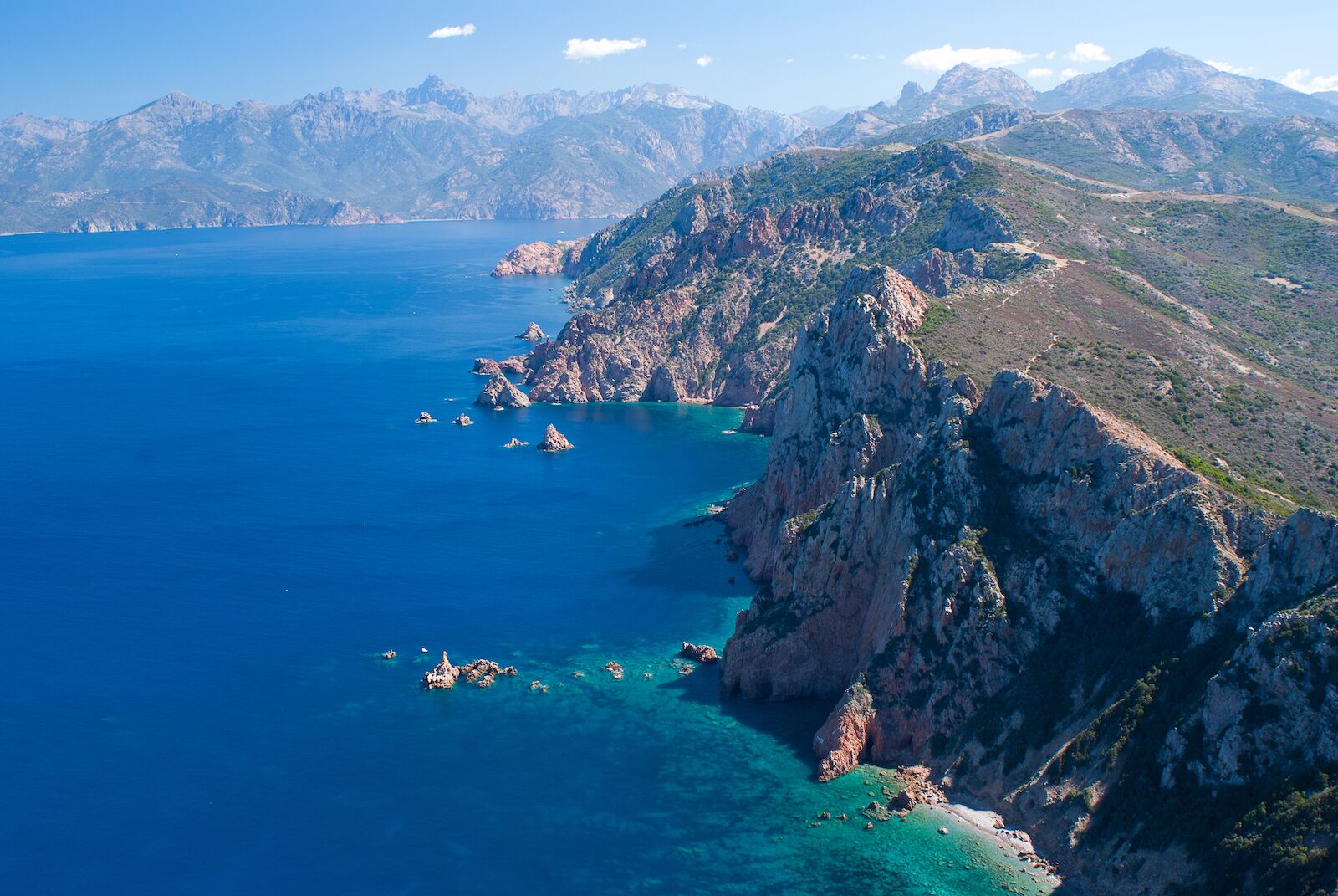
- Date of Inscription: 1983
- Why it’s underrated: Not everyone who visits Corsica realizes they can visit a UNESCO World Heritage site just by driving the coast.
- When to go: May-September
- How to get there: Fly into Ajaccio or Bastia from a major European hub, rent a car at the airport, and enjoy a scenic coastal-drive of under two hours to reach the Gulf of Porto’s hidden beaches and wild red-stone calanques.
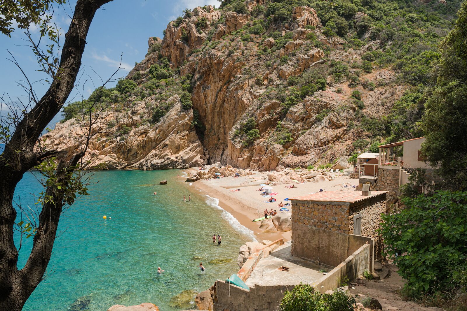
- What not to miss: Tucked beneath the Calanques de Piana, Plage de Ficajola is a beautiful and secluded beach with red pebbles, deep blue water, and views of passing yachts.
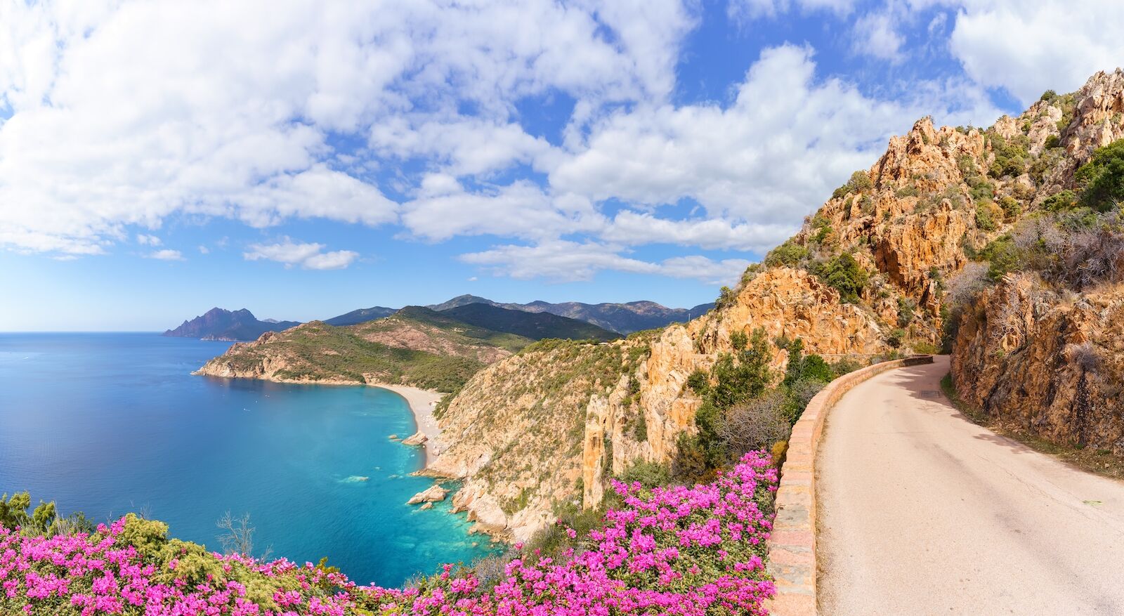
The French island of Corsica spans 3,368 square miles, making it the fourth-largest island in the Mediterranean. Approximately 1,351 of those square miles — some 40 percent of the island — belong to the Regional Natural Park of Corsica. And roughly 45 square miles of that make up this UNESCO-listed gulf on the island’s west side, which includes the Calanche of Piana, Gulf of Girolata, and Scandola Nature Reserve.
The composition of both the land and sea that comprise the gulf helped land it on UNESCO’s World Heritage list. Terrestrially, evergreen shrubs and other vegetation are an excellent example of maquis scrubland, a biome that’s unique to the Mediterranean. Under the water, whose remarkable clarity is also worth recgonizing, myriad types of algae represent just some of the area’s spectacular marine life. Together, these conditions make the Gulf of Porto an important habitat for seabirds, such as seagulls, ospreys, cormorants, and sea eagles.
If you want to stay near the Gulf of Porto’s wild coastline, consider making the hilltop village of Piana your base. Hôtel Capo Rosso has an infinity pool framed by red cliffs and a restaurant specializing in Corsican dishes sourced from nearby farms. From this property, it’s easy to drive winding roads to hidden beaches like Plage de Ficajola or to set out early for a hike among the Calanche’s sculpted rocks.
Hanseatic Town of Visby, Sweden
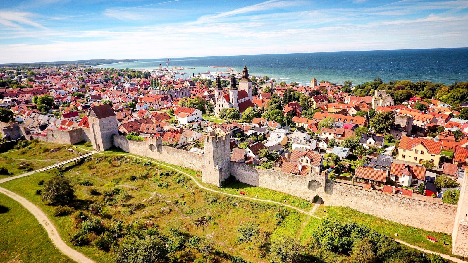
- Inscription date: 1995
- Why it’s underrated: Visby is located on the largest island in the Baltic Sea, roughly 150 miles from Stockholm if you were to travel straight down, where Viking history meets natural beauty.
- When to go: June-September
- How to get there: Fly into Stockholm, then either take a quick 50-minute flight to Visby or board a three- to five-hour train-plus-ferry combo (via Nynäshamn) to Gotland — the old town is just a short walk or shuttle ride from the port or airport.
- What not to miss: After touring Visby’s two-mile city wall, its dozen-plus churches and church ruins, and the Gotland museum, find someplace to refuel with a plate of saffron pancakes. It should be easy — along with Gotland truffles, they’re a local delicacy.
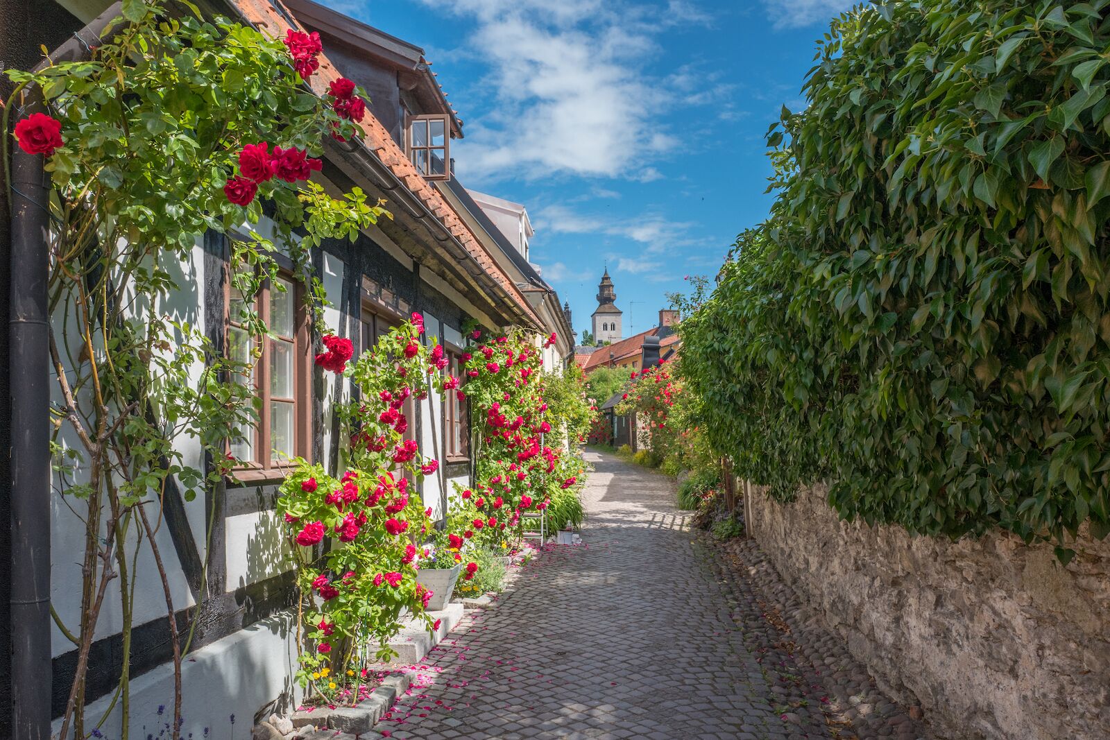
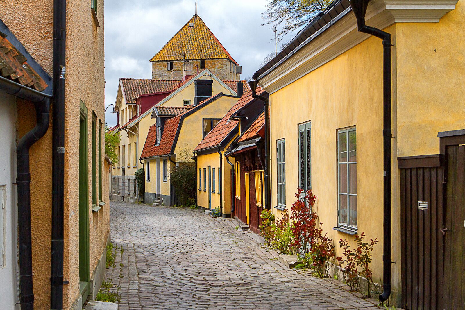
Visby is the capital of Gotland, Sweden’s largest island. It was settled by Vikings during the Viking Age — go figure — and by the 12th century had become an important trading hub in the Baltic Sea. Its tenure as a trading hub lasted roughly until the 14th century, bringing with it the development of around 200 warehouses and merchant quarters.
To this day, Visby is better preserved than any other walled, medieval, commercial city in Northern Europe. It’s still a fully functioning town, but its heritage remains at the forefront of daily life. To see this underrated UNESCO site in its full glory, visit during the summertime Medieval Week, Sweden’s largest historical festival.
Visby’s old town feels like a living museum, and you can wake up right in the middle of it if you stay at Hotell St Clemens, a family-run property just inside the medieval walls. The rooms are individually decorated, and two leafy courtyards provide quiet corners for morning coffee or an unhurried afternoon with a book. If you prefer more modern interiors, Kalk Hotel pairs 17th-century architecture with Scandinavian design and limestone details from Gotland itself. Some rooms come with balconies overlooking the Baltic Sea or Almedalen park, so you can end your day watching the light fade over the rooftops.
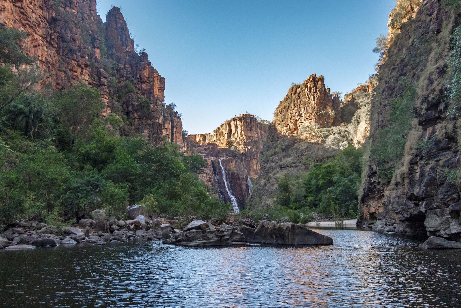
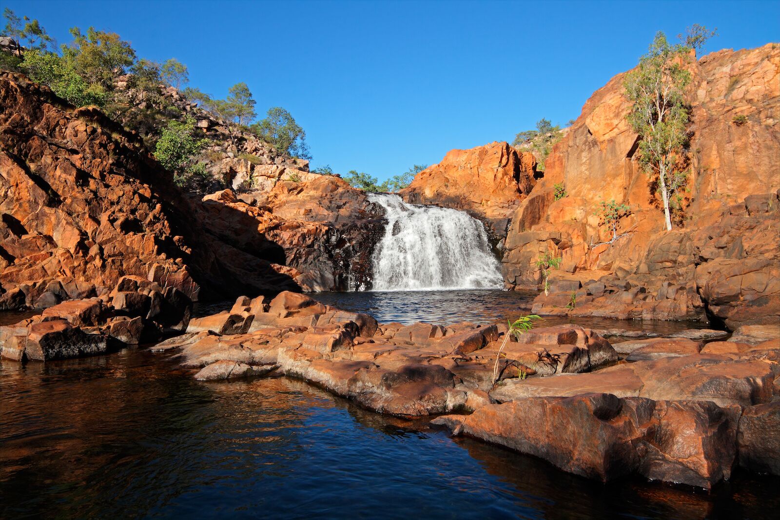
Kakadu National Park, Australia
- Inscription date: 1981 (extended 1987 and 1992)
- Why it’s underrated: It’s almost as big as New Jersey.
- When to go: May-October
- How to get there: Fly into Darwin, rent a 4WD, and drive about three hours east along the main highway into the park — don’t miss the chance to spot giant crocs leaping out of the river and to wander wetlands packed with birds and reptiles on the way.
- What not to miss: Kakadu is full of natural swimming holes and waterfalls. Among the most impressive are Jim Jim Falls, the largest in the park; Gunlom Falls, a natural infinity pool; and Motor Car Falls, which is less likely to come with a big crowd of swimmers.
The Great Barrier Reef might overshadow Australia’s Kakadu National Park in popularity — but not in size. At roughly 7,700 square miles, Kakadu is the continent’s largest national park, and it hosts a range of unique ecosystems, including mangroves, floodplains, and monsoon forests. The list of wildlife that calls the park home is long. It includes some 10,000 crocodiles, which is roughly one-tenth of all the crocodiles in Australia’s Northern Territory, and around 280 bird species, which is roughly one-third of all the bird species in Australia.
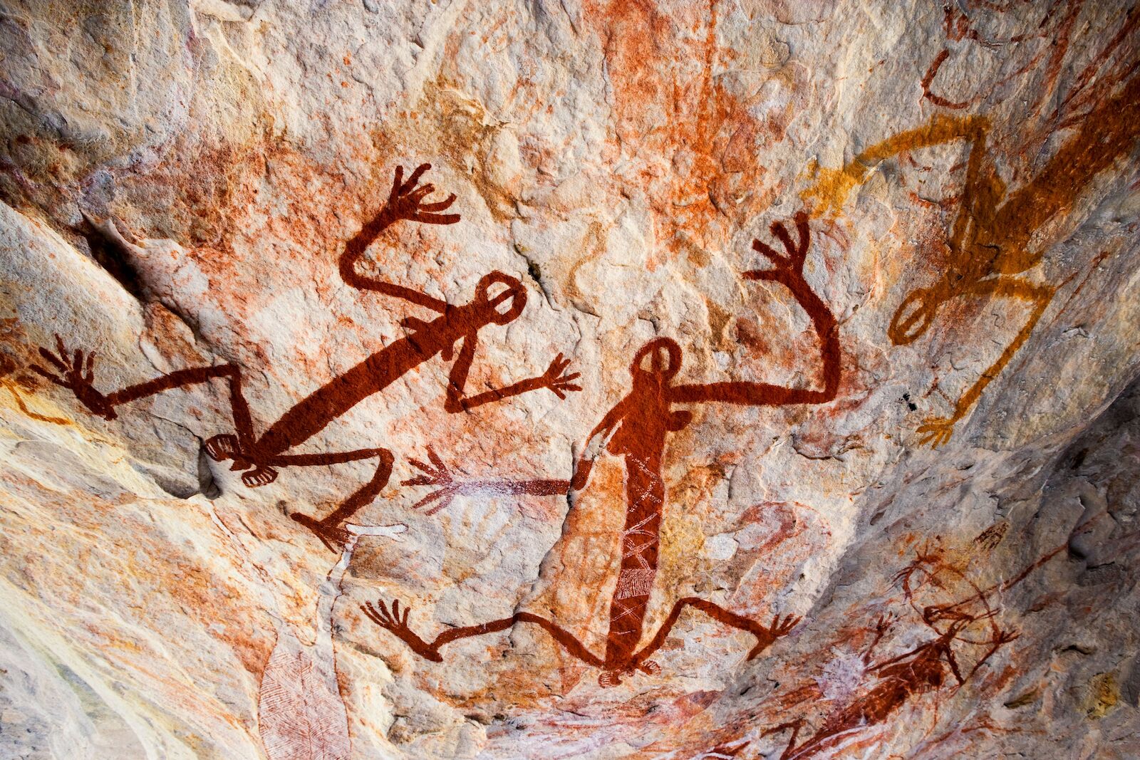
Cave paintings and rock carvings from the area’s original owners, the Bininj and Mungguy people, have also been well preserved within the park. The oldest can be traced as far back as 20,000 years. Members of these Indigenous groups have inhabited the region consistently for over 50,000 years. To this day, they carry on the hunting-and-gathering traditions that began in the Pleistocene Era while also helping to manage the park in tandem with Parks Australia.
You’ll find a wide variety of accommodations both within Kakadu National Park and nearby, ranging from simple camping areas to comfortable lodges and luxury resorts. Campsites differ in their facilities — some are basic bush sites with only vault toilets, while others provide showers, standard toilets, picnic tables, and fire pits. For hotels, check out Mercure Kakadu Crocodile Hotel, the Aboriginal-owned Anbinik Kakadu with its bungalows and cabins, or Hawk Dreaming Wilderness Lodge, which offers comfortable tented cabins and all-inclusive cultural tours. ![]()